Posts

Showing posts from November, 2022

A Series of Storms Poised to Hit Tahoe Through Mid-December

Image
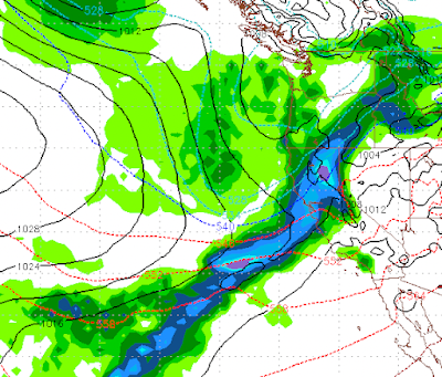
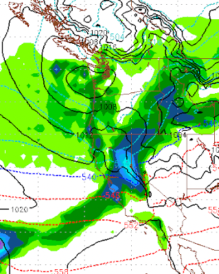
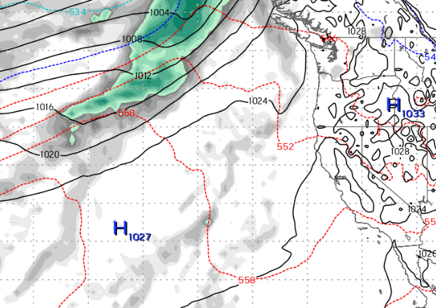
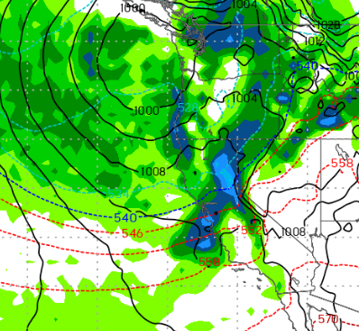
  This graphic shows you the forecast for mid-morning tomorrow. It is a beautiful depiction of what is known as the Pineapple Express. That is a moisture tail that stretches from Lake Tahoe all the way down to the Hawaiian Islands. These sorts of events pull very moist, warm air from the tropics into the Sierra. They usually bring very heavy rain to the California coast and very deep snow to the Sierra. We have two storms, one south and one north that will merge together to form one very large storm, currently here is what things look like: The fun does not stop there. Late Saturday, another storm system forms with another tropical moisture tap that will bring additional heavy snow to the Sierra: This storm will bring near continuous snow from Saturday evening through Monday. As if that is not enough, we have another large storm poised to hit the Sierra next Friday (12/9): With our ridge of high pressure shoved way out to sea, the storm door should remain open through at least the midd

Storm Delayed but Still Promising

Image
Our once promising storm set to arrive tomorrow appears to be delayed. Both the ECMWF and GFS models had forecast this as you saw from my last post. However, not all is lost.  The EC weather model is still predicting a series of storms to impact our area starting next Thursday. In addition, we will have hit and miss stormy weather up until that time. Here is the forecast for Thursday, which should bring a significant moisture hit to the area. Things then get more interesting. The ECMWF model is predicting a major event starting next Thursday and lasting through the following Monday. There will be a slight pause on Friday (12/2), then the big stuff comes in. Remember this is in addition to the Thursday storm: This is the forecast for Saturday (12/3).  The good folks over at the NWS would call this an AR event  (atmospheric river). Formerly known as the Pineapple express.  Here is a look at Sunday (12/4): These AR events bring tremendous amounts of precipitation by tapping into tropical

Trapped Inside a High Pressure Dome

Image
 Currently we have two ridges of high pressure that are dominating our weather. Any and all storms are being shoved north. In addition, our air is so stagnant that we are under a strong temperature inversion. What is a temperature inversion? This occurs when there is little or no wind, almost always during the winter. The warm air rises and the cold air descends. That cold air is trapped and has nowhere to go. Currently it is 20+ degrees warmer in the Sierra than the leeward valleys.  If you read our last post, fear not, change is coming. In fact it is beginning as we speak. A larger storm will drop out of the Gulf of Alaska and begin to shove our ridge out. However, what you can tell by the strength of this inversion, the high pressure dome is quite strong. It will take some time. Here is the forecast for late tomorrow, we are already seeing some movement. By this weekend, our once proud ridge will be all but gone. That will open the storm door into Tahoe. Here is a look at early Satu

We are Expecting a Gradual Pattern Change in about a Week

Image
A ridge of high pressure is sending all storms well north of us presently. However, we expect to see that ridge begin to break down in about a week. That should bring in a pattern change along with a series of storms between the 22nd of November and the end of the month. Currently: Storms are being sent up to the Pacific NW and into BC. However Around the 22nd of this month we see the ridge begin to breakdown: The Pattern Change is complete by the end of the month: What does all this mean? It could be a stormy start to December. Right around the 22nd, our chance for additional snow increases and continues to increase as we move toward the end of the month. Stay Tuned ...

Storm Update

Image
Thus far this storm has been a dud. However, the brunt of the storm is just now moving onshore pushing precip into the Sierra. The rain shadow has been heavy, but with a more southerly flow we should finally start to see some heavy precip on this side of Lake Tahoe and even in the leeward valleys. The brunt of the storm will hit our area on the eastern side of Lake Tahoe starting late morning and lasting through the evening. We could possibly see 12-18 inches of snow up on Mt. Rose, which will greatly help their snow making efforts. The central Sierra, around Mammoth will see the heaviest precip. We will remain in an active weather pattern into the foreseeable future. With a series of storms headed our way and the possibility of a major weather event around the 22nd of November. Stay Tuned ...

Major Storm to Effect Tahoe and Valleys

Image
We have a major storm barreling out of the Gulf of AK and it is headed our way. It will begin to effect our weather this evening (11/6). This is a cold storm and should bring heavy snow to the mountains, Lake Tahoe and the leeward valleys of Reno and Carson City. Here is what we are thinking in the way of timing: 11/7: 2am 11/8: 10am 11/8: 4pm In addition, we have another storm coming in for next weekend: All told, here is what we are looking at for Total Precip: To summarize: We have a major winter storm that will bring very heavy mountain snow and very heavy valley snow. We are looking at 4-5 feet for Mt. Rose and up to a foot on the valley floor. The foothills could see 2 feet of snow. Stay Tuned ...