Posts

Showing posts from March, 2023

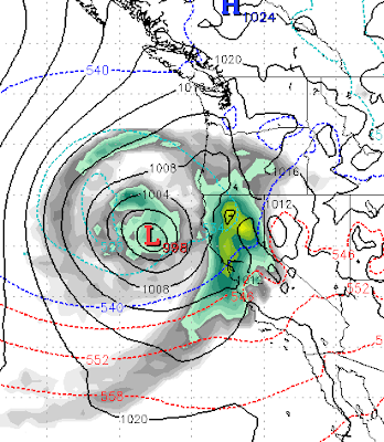
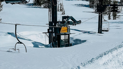
What Kind of Winter Has This Been?

Image
This winter has been one for the ages. Ironically, this is the 2nd snowiest winter for the Sierra behind the winter of 1958. It has also been much colder than average, which means the snowpack is sticking around much later than usual. As my friend Sven mentioned in his last post  , Mammoth has announced they will be open through July! Here are some charts that really illustrate the type of winter we have had. Remember, most California reservoirs are now completely full! Do not look for a quick warmup, here is the temp outlook for the next couple of weeks, which is almost laughable ... almost:  Here is the % of average precip for this winter: How snowy has it been in the Sierra? In addition, we received nearly 8 inches of snow last night in South Reno. Here is the model run for predicted precipitation last night and early this morning: Everybody got fooled by this one, including us! Mother Nature is just toying with us, obviously! Stay Tuned ...

Weather to Remain Cool and Stormy For Next Couple of Weeks (At Least)

Image
Winters tight grip on the Tahoe area will continue into the foreseeable future. We have a series of storms and reenforcing cold fronts that are stacked up and waiting to continue the onslaught on the Sierra and Tahoe especially. Tuesday 3/28 This is a cooler storm, will likely produce snow above 6,000 feet but those levels could drop as well. For now looks like rain for the valley. This storm will send waves at us following the main front for a few days. Monday 4/3 Very cold air dips way down into Central California. Wednesday (4/5) If this holds together, it will usher in a very stormy pattern. Saturday 4/8 Could this be a late season AR event? It is two weeks out, so no guarantee, but anything is possible this year! Finally, here is the precip forecast for the next couple of weeks. Amazingly, the Central Sierra around Mammoth is looking at another 10-12 feet of snow. The western crest should see 6-8 feet while the Carson range is in the 3-5 foot range. Stay Tuned ...

Winter is Back and Will Hang On For a While

Image
After several years of mostly below average precipitation and above average temperatures, Ma Nature is doing her very typical catch up act. Averages exist for a reason and really have not changed since we started keeping records. So we were due for above average precip and below average temps. Ma Nature has us covered. Some of the snow pictures are truly unbelievable. For those of you who did not notice, our friend Sven over at Unofficial Rose  is back. Sven is a backcountry expert and I would strongly suggest following his posts and subscribing ... it could save your life. Ok, back to current weather. After a few days where our temperatures finally got to average, another cold front moved in last night and is reenforcing as we speak. We have several storms in the next 10 days, but these storms are nothing like what we have been seeing. Here is what we are seeing: Tuesday 3/21 This is a fast moving storm that will bring rain to the valleys and snow above 6,500 feet. We do not see any h

Mother Nature Will Continue to Pummel Tahoe

Image
A very powerful jet stream is pulling tropical moisture from the South Pacific and sending it up into a trough of low pressure and dumping it all over California and the Lake Tahoe area. We will continue to see heavy rain for the valleys and heavy snow for the mountains in the 6,500 to 8,000 foot elevation. Snow levels will continue to fluctuate through the weekend as we will receive several waves of additional precipitation. Snow levels during these warmer events will fluctuate and are very difficult to predict. Mt. Rose will receive all snow and should pick up an addition 1-3 feet over the weekend to go with the 2 feet they have already received. This powerful jet, which goes right through the Tahoe area will continue bring strong winds.  But that is not all. Another large, warm and moist storm is on tap for Tuesday: This storm will again start with very high snow levels, in the 8,000 foot range. As the storm moves through snow levels will drop. Starting Wednesday (3/15) we will begi

Warmer Storms Stacking Up, Heading to a Mountain Near You

Image
We are anticipating a significant pattern change starting around Friday, March 10th. We will transition from a cold, stormy pattern to a very warm, stormy pattern. The winter of 22/23 continues.  The storm train starting on Friday is born in the south and will knock this Arctic air out of our area and pack significant tropical moisture. Snow levels will start very high with several of these storms. Currently, we have a snowpack as low as the foothills and a very significant snowpack in the mountains. This winter has been much colder than average so our typical snow melt has simply not occurred. Which is a good thing. Unless of course we start to experience heavy rain at high elevations. This series of storms could bring some flooding concerns. Here is a look at the forecasted storms along with dates and times: Friday March 10th, 12:00am Monday March 13th, 2:00am - Same storm, tail end will bring some cooler air Wednesday March 15th - Beginning of another warm storm Saturday March 18th

Storm For This Weekend Then Anybody's Guess

Image
The models are changing their minds about as often as the average person changes their underwear. One thing they have consolidated on is the storm this weekend and the aftereffects for next week. Here is a look at the forecast for tomorrow evening: Another cold storm and should be all snow for all Tahoe resorts. 1-3 feet depending on the amount of shadowing. This storm will stick around through the middle of next week with weak waves of hit and miss precipitation. After that, it looks like high pressure will settle in. The big southern storm we talked about looks like it is going to get split with one half moving north of us the other half moving south. However, the models appear to change their minds on this daily. For now, however, it looks like we will have a pretty clear sailing, next weekend. Stay Tuned ...