Posts

Showing posts from 2022

Pattern to Remain Active Through Mid-January

Image
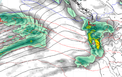
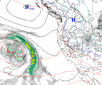
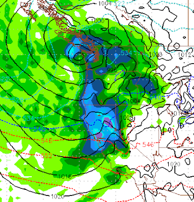
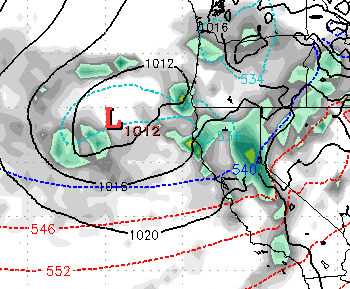
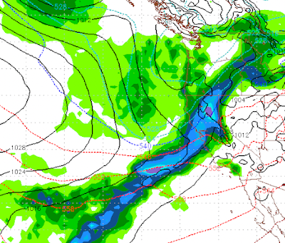
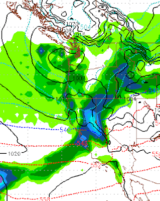
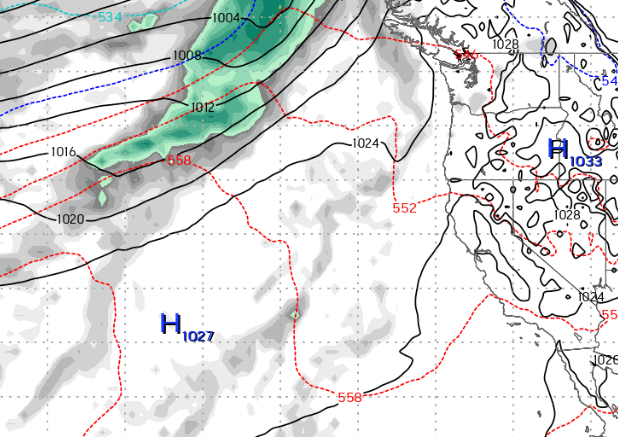
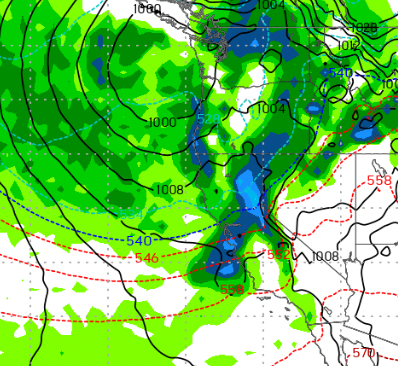
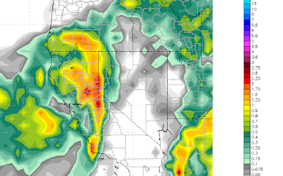
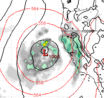
We are in a very active, wet weather pattern. All indications are that this pattern will remain active through at least the middle of January. We are on the cusp of a huge, wet and warm storm moving into the Tahoe Area. This storm has a sub-tropical moisture tap that is very powerful and is moving very warm and humid air into the Tahoe region and driving snow levels up to around 10,000 feet.  However, those levels will fall quickly to around 8,000 feet by Friday night (12/30). Eventually, they will drop down to around 6,500 feet. By then most of the moisture will have moved on. Here is a look at the forecast for Saturday afternoon: We are then looking at a much cooler but also a much weaker system for the 2nd of January: This system breaks up as it hits the Sierra. I expect at most just a few inches of snow for Mt. Rose. Then, another very warm and wet system moves into the Sierra on Wednesday the 4th: This system will stick around and be reenergized through the 8th of January. I bel

Massive Pattern Change Will Bring Heavy Rain to Valleys and Deep Snow to Upper Elevations

Image
Merry Christmas to all! I hope you are having a wonderful holiday season.  If you caught our last post, we have a huge pattern change and it is knocking on the door. Before we get to the timing and snow levels I thought it prudent to show the precip forecast for the next 10 days: We are looking at 12-16 inches of liquid for all the mountains around Lake Tahoe. Just South of the lake, they are going to get buried in the upper elevations. Add this to our already healthy snowpack and you see why averages do matter! Meanwhile, many valley locations will see 5+ inches of rain over the next 10 days. Storm 1 (Tuesday 12/27 @ 4am) This storm is packing a subtropical moisture tap and will be the warmest of the storms with snow levels starting out at 10,000 and dropping through the event. The event will last 20-24 hours and by the end, it will be all snow down to 7,000 feet.  Storm 2 (Thursday 12/29 @ 6am) The next event in the series is actually two storms. This will be another warm event and w

Not a Carbon Copy of Last Year

Image
I have been hearing about all the December snow and am continually reminded that the spigot shutoff for a few months after December, last year. That is not happening this year. First, we have a couple of near misses that will produce some precipitation for the Sierra starting Friday and lasting through the weekend. I do not expect any major storm from this system for Tahoe. The same cannot be said for the Pacific NW as they will get a blast from this one.  Then, next Tuesday (12/27) our pattern changes. A very warm storm will pick up a weak sub-tropical moisture tap and bring rain and snow to the Sierra. Folks, this one could rain to very high elevations (9,000 feet) as the air is very warm. You have to go up to BC to find some colder air. Then, late on Wednesday the 28th of December another system drops in from the north. This will still be a very warm system, but nothing like the previous storm and hopefully will bring all snow to Slide Mountain, although very wet, heavy snow. A thir

Tahoe Will be Dry Through Christmas

Image
After nearly 10 feet of snow at Mt. Rose in the last 10 days, things are going to dry out as a ridge of high pressure will set up just off the Pacific NW and block anything trying to get into us. There is a slight chance of a storm making it through around the 22nd or 23rd, however right now that storm looks to be heading north of Tahoe. Here is the precip forecast for the next 15 days: This may not be a bad thing for the resorts. If anybody remembers what Mt. Rose Highway looked like last Christmas with many of our western neighbors deciding they could drive that road in a blizzard and DOT having to shut it down just to get our friends out of the ditches. This should be a boom to the economy of the entire area.  The storms will return, trust me. Ma Nature has a way of deciding when, so nothing is carved in stone. Stay Tuned...

Weather Pattern to Remain Very Active

Image
  We are tracking a major storm which will start on Thursday (12/8) and last through the weekend. This storm also has a significant moisture tap especially this weekend. The above forecast is for 10am on Saturday (12/10) morning.  The potential of this storm is greater than what we saw last week, where nearly 4 feet of snow fell on Slide Mountain. Here is the precipitation forecast for for the next week: We are looking at another 3-6 feet for Slide Mountain.  Stay Tuned ...

Next Storm Up

Image
Our next storm should begin to make its presence felt tomorrow (12/3) morning. This storm should produce another 1-2 feet of snow for the Carson Range. It has the potential to be more, but right now we are holding off on a huge event. It will linger through Monday but most of the damage will be done on Sunday. We will receive a bit of a reprieve until at least next Friday. I say "at least" because the EC weather model is forecasting high pressure to move in as a blocking ridge which will send storms north. However, the GFS has another storm coming in on Friday (12/9). Truth be told, the EC weather model is usually more accurate. Looking a bit further out, out next weather maker will be coming in around the 13th of December, but let's not get too far ahead of ourselves. Stay Tuned ...

A Series of Storms Poised to Hit Tahoe Through Mid-December

Image
  This graphic shows you the forecast for mid-morning tomorrow. It is a beautiful depiction of what is known as the Pineapple Express. That is a moisture tail that stretches from Lake Tahoe all the way down to the Hawaiian Islands. These sorts of events pull very moist, warm air from the tropics into the Sierra. They usually bring very heavy rain to the California coast and very deep snow to the Sierra. We have two storms, one south and one north that will merge together to form one very large storm, currently here is what things look like: The fun does not stop there. Late Saturday, another storm system forms with another tropical moisture tap that will bring additional heavy snow to the Sierra: This storm will bring near continuous snow from Saturday evening through Monday. As if that is not enough, we have another large storm poised to hit the Sierra next Friday (12/9): With our ridge of high pressure shoved way out to sea, the storm door should remain open through at least the midd

Storm Delayed but Still Promising

Image
Our once promising storm set to arrive tomorrow appears to be delayed. Both the ECMWF and GFS models had forecast this as you saw from my last post. However, not all is lost.  The EC weather model is still predicting a series of storms to impact our area starting next Thursday. In addition, we will have hit and miss stormy weather up until that time. Here is the forecast for Thursday, which should bring a significant moisture hit to the area. Things then get more interesting. The ECMWF model is predicting a major event starting next Thursday and lasting through the following Monday. There will be a slight pause on Friday (12/2), then the big stuff comes in. Remember this is in addition to the Thursday storm: This is the forecast for Saturday (12/3).  The good folks over at the NWS would call this an AR event  (atmospheric river). Formerly known as the Pineapple express.  Here is a look at Sunday (12/4): These AR events bring tremendous amounts of precipitation by tapping into tropical

Trapped Inside a High Pressure Dome

Image
 Currently we have two ridges of high pressure that are dominating our weather. Any and all storms are being shoved north. In addition, our air is so stagnant that we are under a strong temperature inversion. What is a temperature inversion? This occurs when there is little or no wind, almost always during the winter. The warm air rises and the cold air descends. That cold air is trapped and has nowhere to go. Currently it is 20+ degrees warmer in the Sierra than the leeward valleys.  If you read our last post, fear not, change is coming. In fact it is beginning as we speak. A larger storm will drop out of the Gulf of Alaska and begin to shove our ridge out. However, what you can tell by the strength of this inversion, the high pressure dome is quite strong. It will take some time. Here is the forecast for late tomorrow, we are already seeing some movement. By this weekend, our once proud ridge will be all but gone. That will open the storm door into Tahoe. Here is a look at early Satu

We are Expecting a Gradual Pattern Change in about a Week

Image
A ridge of high pressure is sending all storms well north of us presently. However, we expect to see that ridge begin to break down in about a week. That should bring in a pattern change along with a series of storms between the 22nd of November and the end of the month. Currently: Storms are being sent up to the Pacific NW and into BC. However Around the 22nd of this month we see the ridge begin to breakdown: The Pattern Change is complete by the end of the month: What does all this mean? It could be a stormy start to December. Right around the 22nd, our chance for additional snow increases and continues to increase as we move toward the end of the month. Stay Tuned ...

Storm Update

Image
Thus far this storm has been a dud. However, the brunt of the storm is just now moving onshore pushing precip into the Sierra. The rain shadow has been heavy, but with a more southerly flow we should finally start to see some heavy precip on this side of Lake Tahoe and even in the leeward valleys. The brunt of the storm will hit our area on the eastern side of Lake Tahoe starting late morning and lasting through the evening. We could possibly see 12-18 inches of snow up on Mt. Rose, which will greatly help their snow making efforts. The central Sierra, around Mammoth will see the heaviest precip. We will remain in an active weather pattern into the foreseeable future. With a series of storms headed our way and the possibility of a major weather event around the 22nd of November. Stay Tuned ...

Major Storm to Effect Tahoe and Valleys

Image
We have a major storm barreling out of the Gulf of AK and it is headed our way. It will begin to effect our weather this evening (11/6). This is a cold storm and should bring heavy snow to the mountains, Lake Tahoe and the leeward valleys of Reno and Carson City. Here is what we are thinking in the way of timing: 11/7: 2am 11/8: 10am 11/8: 4pm In addition, we have another storm coming in for next weekend: All told, here is what we are looking at for Total Precip: To summarize: We have a major winter storm that will bring very heavy mountain snow and very heavy valley snow. We are looking at 4-5 feet for Mt. Rose and up to a foot on the valley floor. The foothills could see 2 feet of snow. Stay Tuned ...

Cooler Weather Coming to Tahoe; 2022/2023 Tahoe Winter Forecast

Image
 First things first. We have a slider type system that will come down the Eastern Sierra and bring us much cooler temperatures. About 20-30 degrees cooler. This system is expected to arrive about mid-day Saturday (October 22nd). The Northern Rockies and Cascade Ranges will pick up some early season snow. We will not. Our time will come eventually, however, as the storm machine starts to crank up.  Looking ahead to Thursday the 27th, we are talking about a good chance of mountain snow, as a system comes in from the Northwest: Looking over the course of the next 2 weeks we are getting into a classic La Nina ensemble. As the Pacific NW will be very wet with only a few minor events making it to us.  2022/2023 Season Forecast After a strange weather year last, which saw major events in October and December but very dry after that.  Here is a look at the ENSO forecast from the various weather models. ENSO, or El Nino Southern Oscillation, can be a decent indicator of what to expect over the

Much Needed Rains Put Pause on Fire Season

Image
We still have 3 more days of rain that will bring up to an additional 3 inches of rain to the areas burning west of Lake Tahoe. Funny when Nature is pitted against Nature how nature always wins. Yes, nature uses fire to regenerate her forests, but only nature has the power to put out said fires. We should never forget who is in control and it is not us! This blog is now using a new delivery mechanism, follow.it , to deliver content to your email inbox. There will always be an unsubscribe link. You can also filter what you see as well:  https://follow.it/tahoe-weather-blog?action=followPub&filter Our old delivery service, feedburner, simply stopped delivering, therefore we have used follow.it as a Feedburner replacement .  We will be posting our 2022/2023 winter season forecast in the coming weeks. Stay Tuned ...

Weekend Storm Should Dampen Fires

Image
We have an early season storm that will drop down the coast and make landfall in Northern California. It will then move west directly over the fire areas. This storm should produce some precipitation, which will greatly aid the effort to put out these fires that are burning due west of Lake Tahoe. This storm will bring much cooler and more humid weather and the winds do not appear to be nearly as strong as once thought ... all good news. We are looking at from 24-36 hours of light rain and possibly some snow over the fire areas.  We are also looking at our first high mountain snows of the season. We see an above average snowfall winter for Tahoe, and will post our season predictions in the next few weeks after we aggregate all the data. Stay Tuned ...