Posts

Showing posts from April, 2011

Inadequate Moisture Tap for Large Storms
Image
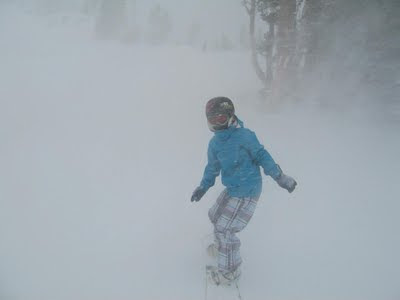
The models are now backing off of the high pressure system moving south. In fact by the end of next week they have it dominating the entire west coast. So expect more of the same. That is not to say the potential does not exist for a large storm at this time of year. However, chances are greatly diminished. Remember last year? Here is a picture of my daughter snowboarding on Easter Sunday. I took this picture from about 5 feet away from her in the afternoon on Slide Mountain: That stormed moved over the mountains and dumped in Reno too. I guess what I am saying is that the winter winds down, the potential does exist for one or two more pretty good sized storms. In fact, I would be surprised if that does not happen. Happy Easter!
High Pressure Slides South, Storms Slide In

Image
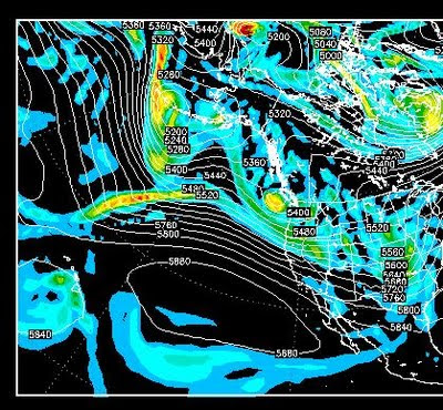
Here is a look at early next week, notice the the blocking high has moved well south and the storm track is now back in Northern California ... More later.

We Remain on the Extreme Southern End of the Storms

Image
The ridge of high pressure that has been sitting off the west coast for what seems like a month, does not appear to be going anywhere. This is causing the storms to move well to our north. Occasionally, the ridge gets backed down by a stronger storm and we get a glancing blow, which comes in the form of mostly wind and minor amounts of precipitation. Here is a look at what has been in place now for a couple of weeks: You can clearly see the blocking high pressure system. We are right on the edge of the block which is why we are getting an occasional wind storm. That will not change. Expect minor disturbances Tomorrow and Thursday. I do not see any major storm activity. However there are some signs that the blocking high will eventually move on, which may open the door for more energy to hit our area. We are moving from a La Nina back to an El Nino. I will talk about that in the coming posts. Stay Tuned ...

Storm Moves Further South and Strengthens

Image
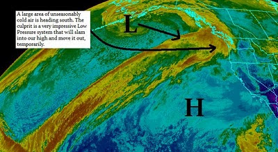
Current We have two impressive systems that are going to collide. The high pressure to our west is going to give way to a very impressive Low Pressure system to our north. There is a decent moisture tap, however this storm is coming straight out of the north. That means the tap will not be as wet. If this system stays just a hair west, we will get more moisture. For now, however this looks like an ok snow event for the Tahoe Sierra with 1-2 feet at the Sierra Crest and 6-15 inches in the Carson Range. It is going to get cold. The chart below shows what is happening. Notice the area just south of the low. That is some seriously cold air. Some of that air is coming our way for tomorrow and tomorrow night.   Looking Ahead We are again going to be on the southern edge of some very impressive storms for this time of year. This gets cranked up next week. I talked about the PNA going negative, it looks like we will have a decent chance of being hit by 1 or more storms in the next couple

Quick Update

Image
The 00z run of the EC weather model is predicting a strong storm for the Lake Tahoe area starting Wednesday and lasting into Friday. EC has this storm dropping straight out of the north. This will bring limited precipitation to the Sierra. It will also bring in some unseasonable, if not unreasonable temperatures. Areas of the Sierra could dip below zero as the cold front pushes through on Wednesday. EC is bold on predicting that some snow will fall on Thursday into Friday as a reinforcing front pushes in behind the big cold front. The leeward valleys will see no precipitation. Here is what EC see's for Thursday (GFS and NAM disagree): Because of the cold temperatures, snow to water ratios will be very high. EC is predicting about .5 to 1 inch of liquid precip for Tahoe and 1-2 inches for Mammoth. That translates into 6-18 inches for Tahoe and 1-2 feet for Mammoth on Thursday. The weather models are not in agreement, but the NWS is leaning toward the EC model. Stay Tuned ...

Mixed Bag Makes Forecasting Difficult

Image
This time of year it is very difficult to look very far out with any sort of accuracy. The following chart explains why: This chart illustrates where we are and where we have been for nearly a week now. There are still some very strong, unseasonably strong, storms spinning out of the Gulf of Alaska and Pacific Ocean. However we have a very strong area of high pressure right off the California coast. Any storms that attempt to make their way down to our area are blocked. Occasionally, a long wave sneaks through and brings us wind, cold and some very light precip, like this past weekend. We will get a few more waves sneaking through over the next week or so that will only influence our weather with wind and cold. However, if that high pressure breaks down, and it has not shown any signs of that, it will open the door for more stormy weather. Taking a look at the PNA, which when negative oftentimes means stormy weather for us, there is a chance that we could be looking at a change, p