Posts

Showing posts from 2024

If You Think El Nino is Done With Us; Think Again

Image
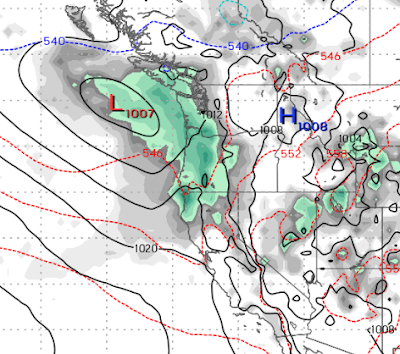
What a beautiful run of spring weather! Don't get used to it. It is coming to a screeching halt on Friday. We see a pretty major pattern change that will bring the possibility of a few strong storms to the Sierra and even over to the Carson Range. One thing for sure, your upper 70's (in the valley) will be replaced with upper 50's with lots of wind. Here is a look at the forecast for Thursday. That trough of low pressure is going to change everything. Behind it is a significant cold front that will bring our temperatures down below average for at least the next few weeks. It will open the door for more storms that have some potential to bring in a late season Sierra Snow Storm. We will really feel the pinch next week around Tuesday. Notice the cold air (light blue line) heading to our area. That is typical of what we may see in January. Finally, as the storm door stays open and our weather is dominated by air from the north: This system could usher in a major storm. That st

Significant Cold Front with Some Precipitation Headed Our Way

Image
 Enjoy the warm, sunny weather. It is not going to last. We have been talking about a cold front which will make it's way to our area starting later on the 4th. With that cold front we are talking about some precipitation as well.  Temperatures should bounce back around the 9th of the month and go above average again. I would probably wait on turning on your irrigation until at least then. Here is a look at the forecast for Thursday evening (4/4): This will be our best chance for precipitation and we will see at least a few flakes all the way down to the valley floor as the cold front moves through on Thursday night and Friday. By the 11th of April, our temperatures should be back above average. As we move later in the season, our storms will be weaker. However, Ma Nature always spins up a surprise when we least expect it. As far as seasonal averages are concerned, we are now above average in precipitation for our 2nd straight year. Of course 3 years ago we were slightly below aver

Significant Storm on Tap for this Week

Image
Sorry about the delay, had to take a little time off. We have a storm that will have a significant impact on the area. The storm will approach Tahoe on Wednesday evening: The storm will send several waves of moisture. Then take a break on Thursday (3/28). It will then regroup and bring more precip to the are on Friday: Here is the precip forecast for this week: The Western Sierra crest will pick up nearly 5 feet of snow. The Carson Range will be in the 1-3 feet range. Temperatures will remain below seasonal averages for this time of year. They will recover this weekend and to near average or even above average. However, we are tracking a strong cold front moving down into our area around the 4th of April, that will bring our temperatures back to well below seasonal averages. Stay Tuned ...

Spring is Coming, No Storms in Sight

We are seeing zero storms in the near future. A very weak system will move through tomorrow but produce no significant precip on this side of the Lake Tahoe. We are looking at temps in the upper 60's for later in the week. High pressure moves in and we will be dry for at least the next 2 weeks.

One More Day, Then General Drying Trend

Image
As is often the case, when we get walloped by a big storm, it changes the entire pattern. The ECMWF weather model says 1 more day then light snow through Wednesday then a general drying trend. Temperatures will recover to the lower 50's but for the most part stay below average for this time of year. The GFS weather model does have a stronger system for Tuesday and then another system for a week from Monday. For now we will stick with the European model. Here is a look at the middle of next week as a blocking ridge of high pressure is going to move in and send any storms to the north for a while. That should give the resorts time to dig out. Stay Tuned ...

Significant Storm(s) Knocking on the Door; Record March?

Image
The NWS has issued a blizzard warning for the leeward valleys of Northern Nevada. These guys are professionals and are very good at what they do. In addition, we are looking at the possibility of over 10 feet of snow for the Sierra, including the Carson range. Our forecast is mountain snow through March 15th on most days! We could see an additional 10-15 feet of snow on Mt. Rose by the middle of March. Here is some timing: Thursday Night 2/29 The storm approaches and begins to slam the West side of Lake Tahoe. Even the leading edge of this storm is cold, we see initial snow levels below Lake Tahoe, which is great news for all resorts. Friday Late Afternoon 3/1 The storm stalls and gathers steam. This portion of the storm will deliver very significant snowfall over the Sierra. Snow begins in the Leeward valleys after starting with rain. Saturday Night 3/2 The storm remains stalled. Notice how the cold air meets the warm air right over Lake Tahoe. What a party this will be! Sunday Evenin

Colder Storms Heading Our Way

Image
In an about face, El Nino has decided to send us some Arctic air along with some tropical air. These two air masses are going to meet right over Lake Tahoe. We believe the Arctic air mass will win out in the end and bring about a week's worth of snow at much lower elevations. Things begin next Tuesday with a weak system that will leave very little snow but bring it high winds. The party really gets started about midday on Thursday (2/29): We are on the outer rings of precipitation of a massive storm to the north. That storm is going to charge south, run into a much warmer air mass and stall. Here is the timing: Friday (3/1) late afternoon Saturday 3/2, Late Morning (storm stalled)   Sunday 3/3, Early Morning  We will feel the remnants of this storm through Tuesday (3/5). Temperatures will not recover and stay well below average through at least March 9th. The majority of the precip will come on Friday, Saturday and Sunday of next week. Here is the precip forecast for the event: If

3 Storms Knocking On Door; Cooler Storms Begin in March

Image
We have 3 storms sitting out in the Pacific Ocean ready to make landfall and bring rain and snow to the area. These are warmer storms, but will turn progressively cooler. Then around the 28th, a strong area of Low Pressure sitting off the BC Coast, combined with a ridge of high pressure well off the California coast, will create an alley for much cooler storms at the beginning of March. Typical of El Nino, we have many weaker storms. These storms are, however, beginning to add up as we are now at about our average precipitation after a very slow start. There is no end in sight for the storm train. Here is what we are seeing and when. Notice the red, blue and light blue lines. That represents temperatures with the light blue being much cooler and red being much warmer. Today @ 10pm (2/17) Tomorrow @ 9pm (2/18) Monday @ 6am (2/19) The storm starting Sunday will stall and dump tons of rain over most of California. This storm should put us above our seasonal average. After about 4-5 day br

Short Break, Storms Return Friday

Image
The last weather pattern was an overachiever. The first of the season! Mt. Rose even managed to open the world famous Chutes. For those of us fortunate to be there on Thursday, they were spectacular.  We are in for some stable weather through Thursday with gradually increasing temperatures that should hover around average for this time of year. Then, a major pattern change comes to Tahoe and all of California. This pattern has some potential for some very serious snowfall in the Sierra and even the potential for heavy rain in the leeward valleys of Reno and Carson City. Here is what we are seeing now: Friday night (2/16) Saturday night (2/17) Monday Afternoon (2/19) - Notice the moisture tail and warm/cold air convergence Tuesday night (2/20) You get the idea. We have a very active pattern that comes inland sometime Friday and could last for a week or more. A few qualifiers here. The GFS model is very bullish on this event. The EC believes there could be a rain shadow effect for the Ca

Next Storm Set For Sunday

Image
Warm moist air is going to collide with very cold air from the north and create what should be a pretty decent storm. Remember, this last storm they were predicting up to 3 feet. We ended up with 6 inches in the Carson Range. This storm has some potential to carry over the Sierra into the leeward valleys of Nevada. Here is the latest forecast for Sunday Morning. This storm has a ton of moisture to work with. Snow levels are going to be tricky however. Very cold Northern air and very warm and moist Southern air. Our best guess is for snow levels to start around 8,000 feet on early Sunday morning. That will drop to lake level throughout the day. For the northern Sierra and Carson Ranges, the most reliable weather model has this storm cleared out by Monday morning. Mt. Rose should pick up 2-3 feet of snow. As we get on the backside of this storm, snow levels will drop to the valley floors so Monday morning traffic could be a nightmare. That is our best guess, but when you have two converg

Series of Storms For Next 5-7 Days

Image
 I hope you are enjoying the warm weather because it is not going to be around for long. We have a series of storms that are poised to hit the Tahoe area and bring all snow to Mt. Rose and mostly snow to the rest of the Tahoe Ski Resorts. The first storm hits tomorrow and will last through Thursday. Behind that storm is some very cold air. Our high temperatures will by 30 degrees cooler than today. Here is the forecast for early Thursday (2/1) morning: We were expecting that very cold air to make it down, but another storm, which will move in from the South will change that. Here is the forecast for Sunday morning: This truly is a collision of warm and cold air with plenty of moisture to work with. This storm will be around for about 24 hours. Behind it is more cool air that will stick around until the following weekend (2/10). After that we are looking for a warm up as high pressure moves in. Here is the precip forecast for the next 7-10 days: Typical El Nino, weaker and warmer storms

Will February Roar In Like a Lion?

Image
We are now in a more typical El Nino pattern. As small waves of precip will continue through most of this week. We are looking for storms to continue to move further south, be strong enough to pull up sub-tropical moisture and cool enough to produce snow. Unfortunately, that is a rare combination with El Nino winters. Mostly, we can expect warmer temperatures as the storms approach. But, 2 out of 3 aint bad, right? Looking ahead we are seeing the possibility of a decent sized storm to develop toward the end of this month or the beginning of next month. Here is the forecast for the 31st of January. Remarkably, the long term models seem to mostly be in agreement about this event. Generally, that is a fairly reliable predictor. The above is the European model, here is the Canadian: Eerily similar. Both these models have this coming in as a very warm and slow moving storm. I believe we will have all snow up at Mt. Rose and snow levels will mostly hover around 7,000 for the majority of this

Storm Train to Continue; Season's First Big Storm This Weekend Into Next Week

Image
Another fast moving, reasonably warm storm is knocking on the door. This storm will move through the area very rapidly and probably leave around 2-4 inches of very wet snow in the Carson Range and Mt. Rose in particular. Here is for forecast for tonight (1/16) around 11:00: This storm will be out of the area by early tomorrow morning but should leave some snow down to about 5,000 feet on the backside. Because the leeward valleys currently are experiencing a very deep inversion, there is a possibility of some freezing rain, which is a very rare occurrence in these parts. Take a look at this setup for the coming series of storms starting very late on Friday (1/19): This is a typical El Nino setup, with several smaller storms that will move inland one after the other. The big stuff is forecast to come in starting Sunday (1/21) afternoon and will hit the entire state of California. So we are looking for snow, on and off, starting Friday and lasting through the following Tuesday. The one do

Next Storm Up For Saturday, Then Warming Trend

Image
Our next storm will come in much warmer than this past storm. It could even help DMV get the roads somewhat passible in the valleys. This storm will tap into tropical moisture, but the snow to water ratios will be much lower. Put another way, we will get more moisture but either the same or less snow in the mountains. Here is the forecast for 4:00pm on Saturday (1/13): As this storm begins to hit our area, we could see some valley snow due to the Ice Box Effect. Currently, the snow cover and surrounding mountains are holding the cold air in the valley. However, as the storm begins to come through, the warmer air will mix and we believe it will bring rain and a very soupy mess. As far as the Carson Range, we are looking for 1-2 feet of snow. Again, this is a fast moving storm and will be clear of our area by early Sunday morning. Much needed relief will follow next week as we will see valley high temps well into the 50's. El Nino will continue, however, next weekend with what is sha

Storm Machine is Beginning to Crank Up

Image
These recent storms are certainly not indicative of what we would consider El Nino storms. However, after a very dry start to winter we will take it. We have been talking about the possibility of the storm machine finally showing up and we are seeing signs of that. First, we have another very cold slider type system, dropping out of the north for late Tuesday into Wednesday. Precip amounts for these types of storms are very tough to predict. Here is a look at the forecast for Wednesday: This will be all snow all the way down to the valley floors. We will probably squeeze out 6 inches and a dusting in the valleys. We are tracking a much larger storm for Saturday (1/13). The models are in good agreement about this event. This storm has the 2 elements we like to see; cold air from the north, warm and moist air from the south. What it is lacking is a blocking force to the East which would allow the storm to stall and dump. We don't want to get too far ahead of ourselves, but we are see