Posts

Warm Weather Continues, But Changes Coming

Image
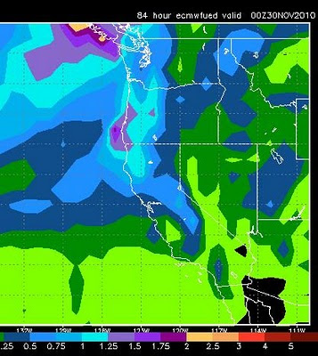
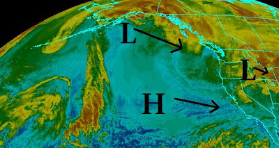
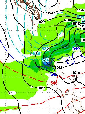
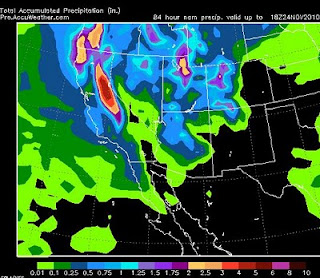
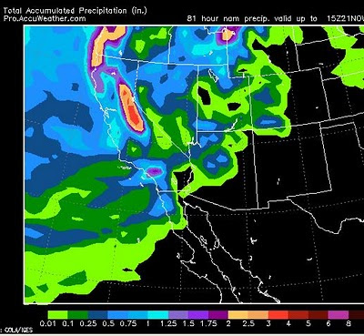
Typical Tahoe The Jet Stream remains well north of Tahoe which means mild weather with minor interruptions when smaller, weaker storms come through the Lake Tahoe area and leave 6-12 inches of snow behind, followed by more mild weather. That will continue with snow above 7,500 feet today and tonight, then mild Thursday followed by another short wave Friday. I played 9 holes of golf late yesterday afternoon, in shorts pants and short sleeves. Today, with early release, Scott and I will head up the mountain and tear it up for a few hours. Mid to Upper 60's For Valley This Weekend A large, warm ridge of high pressure moves in for this weekend through the beginning of next week. That will bring above average temperatures to the entire region with highs in the 50's in the mountains and 60's in the valleys. We may even be able to squeak out a 70 if we are lucky. Look for the slide side parking lot to be filled with tailgaters this weekend. Extremely Wet Pattern Starts Up

Warm, Wet Storm Coming Our Way ... Storms Start Up Again In 10 Days?

Image
The weather models are in alignment. A fairly weak, warm, moist air mass will move into the Tahoe Basin over the next several days and drop around a foot of snow above 7500 feet. Looking forward, the warm air will stay in our area for at least another week. Looking way ahead, GFS has a fairly significant storm coming our way in about 10 days. This storm could bring significant mountain snow to the Tahoe area. Take a look: The bad news is that this storm is 10 days away and much can change. The good news is, that this storm is the first in a series of very large storms that could affect the area. Take a look at the GFS forecast for two weeks out: The really good news is that the PNA seems to be in agreement with GFS and has us moving into a stormy pattern that could exceed what we have seen over the last few weeks: Remember as the PNA goes negative, our storms increase! Keep your fingers crossed and stay tuned ...

Storm For Tomorrow Update

Image
The storm for tomorrow will reach the Sierra by late morning and should dump about another foot or so of snow on the High Sierra with lesser amounts at lake level (3-6 inches). Mt. Rose should receive between 6-12 inches to cover up some of those bare spots. The NWS is talking about a chance for 1/4 inch of liquid precip in some parts of the leeward valley's. That means this storm will likely have no affect on Reno and Carson City. However, this will affect driving over the mountain passes, but everything should be cleared out by Sunday afternoon and travel should be pretty good. For the powder hounds out there, Sunday morning may be the best time to hit the resorts as the storm should have a greater affect late Saturday afternoon into Saturday evening. Here is a quick peak at total, liquid precip for the storm: Looking ahead, EC has another storm coming in next weekend that I will track. For next week, a few short waves may affect the area, but otherwise dry conditions will

Weekend Storm Update

Image
I will rarely post current conditions, but the following map shows what is going on now and what we can expect for this weekend: Right Now Currently there is a very deep low pressure system moving inland through the state of Oregon. This low is going to cause havoc through the central and northern Rockie Mountains with blizzard warnings posted for Salt Lake City and many other areas of Idaho, Utah and Montana. Behind the front is a short wave of precipitation with very cold air. That has already begun to dump very heavy snow in the Sierra and will spill over and cause near white out conditions in Reno, especially west of 395. Be aware, this should occur around 9-11am, so you may want to be off the roads! Thursday and Friday The high pressure system off the California coast will be in control and bring rapidly clearing skies. However, the cold air will be trapped in the valley and this will result in deep temperature inversions. Expect the higher elevations to be much warmer as

Strong, Cold Inside Slider for Tuesday

Image
More heavy snow coming to the Sierra tonight through Tuesday when an inside slider drops down from Oregon. The models are in agreement that the Sierra will pick up an additional 1-2 feet of snow. The NWS service has posted winter storm warnings for the entire Lake Tahoe Area. With this storm comes a very cold, Arctic air mass that should bring some of the coldest temps we have seen in quite some time to the area. Especially the valley floors. The cold air will be trapped by the sourrounding mountains as a high pressure ridge moves in for Wednesday-Friday. This will cause temperature inversions. The lowest parts of the valley will see below zero temperatures on Wednesday night. Here is a GFS look for Tuesday late morning: It is my understanding that the good folks up at Mt. Rose are working very hard to open the NW lift in time for Thanksgiving. With the new snow on the way through Tuesday, I am guessing that Rose will be open top to bottom on the Rose side for Thanksgiving, so ge

Quick Storm Update

Image
This storm continues to pound the region and will continue, on and off, through Wednesday morning. A very strong Arctic cold front will move into the area Tuesday through Wednesday and temps will plummet. We are talking below zero temps in the valleys for Wednesday night. Here is an udpated precip amount map: Most of the Sierra is going to pick up around 4-5 inches of liquid precip by the time this is over. That translates to 30-80 inches of snow with the central Sierra Crest getting the most. A very strong temperature inversion moves in for Thursday and Friday with mountain warming and very cold temps in the valleys. This is ahead of what looks like another decent system moving in for next weekend (See last post). Stay Tuned ...

Storm Strengthens

Image
Storm Update In what is typical La Nina fashion, the storm I have been discussing for the last couple of weeks has strengthened and is heading to Tahoe. This is an extremely deep low pressure system, especially for this early in the year. It is also a very cold storm. This storm formed in the Bering Sea, dropped into the Gulf of Alaska, and is now heading down the West Coast. As it approaches our area, it will tap into additional Pacific Moisture. It will rise into the Sierra, Condense and dump! There are several waves of snow associated with this massive storm. These waves will represent very heavy snow. The first wave should start up around 3:00am on Saturday and last for about 12 hours. Then we will get a brief reprieve before another short wave shows up around 10:00pm on Saturday Night and should last through Sunday morning. From there, we can expect light to moderate snow to last through Monday morning. I will stay with my snow total amounts of 12 days ago, 2-4 feet in the Sierr