If You Think El Nino is Done With Us; Think Again
What a beautiful run of spring weather!
Don't get used to it. It is coming to a screeching halt on Friday.
We see a pretty major pattern change that will bring the possibility of a few strong storms to the Sierra and even over to the Carson Range. One thing for sure, your upper 70's (in the valley) will be replaced with upper 50's with lots of wind.
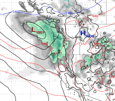
Here is a look at the forecast for Thursday. That trough of low pressure is going to change everything. Behind it is a significant cold front that will bring our temperatures down below average for at least the next few weeks. It will open the door for more storms that have some potential to bring in a late season Sierra Snow Storm.
We will really feel the pinch next week around Tuesday. Notice the cold air (light blue line) heading to our area. That is typical of what we may see in January.

Finally, as the storm door stays open and our weather is dominated by air from the north:

This system could usher in a major storm. That storm will pull up very warm air from the south and could create quite a mess, especially with our snow pack being well above average. We are thinking first week in May.

Stay Tuned ...