Posts

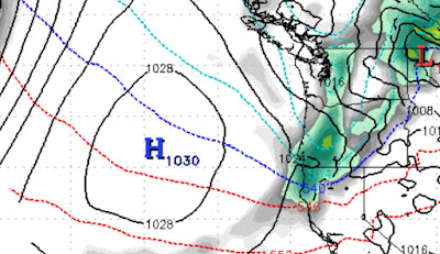
As High Pressure Builds In, Expect Dry Conditions with Above Average Temperatures

Image
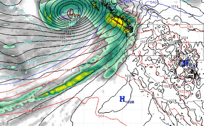
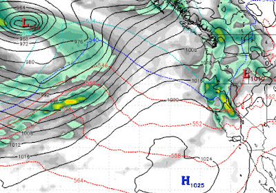
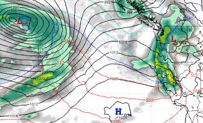
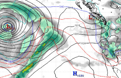
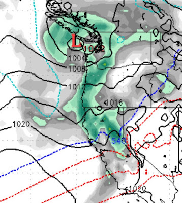
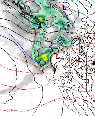
  This chart says it all. There are plenty of storms that are tapping into copious amounts of sub-tropical moisture. However a very strong ridge in the Jet Stream is pushing those storms well north of Tahoe into British Columbia. The models are predicting a pattern change to much drier weather with above average temperatures into the foreseeable future. The only good news in this scenario; the models have been struggling all year forecasting our weather more than 3 days out. We expect this to change, when it does we will report accordingly.  For now enjoy the beautiful weather, 60's in the valley are coming, so get that golf game going again and enjoy some great turns at all Tahoe resorts. Stay Tuned ... 

Three Storms; Then Dry

Image
 We have been talking about this storm for weeks. It will begin to effect our weather starting very late tonight and lasting through most of tomorrow. We expect snow elevations to be right at 6,500 feet for the majority of the storm, when the cold front comes through, the temps will drop along with the snow levels, but most of the precip will be long gone.  We expect 8-16 inches of wet snow for the Carson Range above 7,000 feet. The peak of the storm should bring major winds that will shut down lift operations. If the lifts run at all tomorrow, it will be first thing, but that is doubtful at this time. Here is a look at the peak of the storm in the early afternoon tomorrow (1/4/2021): This storm is fast moving or we would expect much more snow. Notice the ridge of high pressure well to the south. As this storm passes through, that ridge will begin to build again. There are several other storms that we are tracking that will continue to bring varying amount of snow to Tahoe. Most of the

Several Storms Take Aim at Tahoe; Models back off Major Weather Event

Image
 Happy New Year! We are tracking several storms the first is poised to hit Monday: All models have consolidated and we think this could bring 8-12 inches to the Carson Range. In  a year when the models are constantly refactoring the weather pattern, it is hard to be sure about anything else. The pattern will remain active, a chance does exist for a major snow event, but right  now the models have the storms being pushed just slightly north. The next storm will show up on the 6th of January. This storm will approach the West Coast and then split. Where that split occurs is going to determine how much precip we get. Right now it could be between 2-12 inches, we are confident that this will not be a major producer. High pressure is well to our south. That is forecast to move north and push the storms into Oregon and Washington. So to sum it all up; we remain in a very active weather pattern. This pattern will continue for at least the next several weeks. Tahoe will see a fair amount of sn

Active Weather Pattern to Continue into January; Major Storm for January 3rd?

Image
 We are tracking a couple of storms and a very active weather pattern. The first storm should produce 4-8 inches of snow for the Carson Range starting very early on New Years Eve. This will be a fast moving storm. What we are really tracking is that storm out in the Pacific. That storm is going to shove the ridge of high  pressure south and flatten it. That will allow the chance for a major snow event here in Tahoe. The models are in pretty good alignment for a major storm to hit our are around the 3rd of January: Much of this depends on how far north the storm tracks, but we are keeping our eye on this one as another storm will move in right on it's heels and could produce another major snow event. Combined, this could be the event we have been waiting for. Here is a look at the January 5th forecast: And the January 7th Forecast: Notice the flat ridge of high pressure well to our south. Also notice the sub-tropical moisture connection. We do not want to get too far ahead of oursel

Snow Starts Tomorrow; Last Through the New Year and Beyond

Image
Merry Christmas, Happy Holidays, Happy New Year to all! Our pattern change is really starting to take hold. We have a series of storms coming to Tahoe that will begin tomorrow and last through at least the 3rd of January with few breaks in between. Like old times! Tomorrow's storm is shaping nicely: The next storm we had coming in on the 28th. However, the models are showing that storm actually moving south into So Cal, very un La Nina like. However it will deliver some very beneficial moisture down there where they need it. The next storm will begin to effect our weather around the 29th of December. This is a complex storm with cold air from the north and moist, sub-tropical air from the south. We like that combination. This storm is going to effect nearly the entire west coast. One thing you will not see in these charts is the ridge of high pressure which tends to setup off the west coast and push storms north. Finally, you can see the storm in the western Pacific. That too will

Near Misses then Christmas Day Storm

Image
Our weather pattern continues to be active. As high pressures keeps storms north of us, a few of those storms will give us glancing blows. Then on Christmas day, the chance exists for a decent storm. To this point, we have not seen a giant La Nina storm, but we believe that it is coming, probably in January. Here is one of those near misses as a storm delivers us a glancing blow on late Monday / Early Tuesday (12/21), the NWS is more impressed with this storm than we are, so the chance does exist for some accumulation. From what we are seeing, just a few inches of mountain snow at best as the cold front drops temps: Notice the blocking ridge of high pressure. That is going to keep the storms north of us. However, that ridge is going to get knocked south and severely flattened. This will allow storms to drop south and into the Tahoe area. The first of those storms will arrive around Christmas Eve and last through Christmas day: You can see another storm right on the heels of the Christm

Pattern Changed; Next Storm Up

Image
Our weather pattern has taken an about face. The next storm in the series comes in very early Thursday morning. We are expecting another foot of snow for Mt. Rose from this storm as well. These are smaller storms that simply are not indicative of La Nina. Meanwhile our ridge of high pressure is being bounced all over the Pacific. That makes the models change their mind quite frequently. There are still a series of storms stacked up in the Pacific. The models are NOT showing any storms (after Thursday) hitting the Tahoe area until around Christmas. We do not believe that. We think this pattern will continue. For now, this next storm and the past storm should greatly improve skiing conditions. Stay tuned ...