Posts

Weak Storms Are Paving the Way For Much Stronger Storms

Image
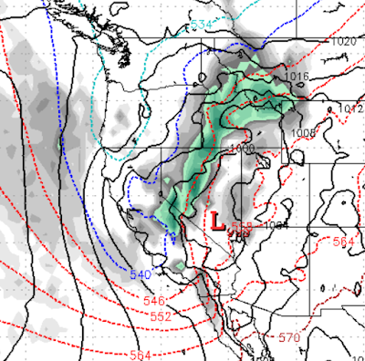
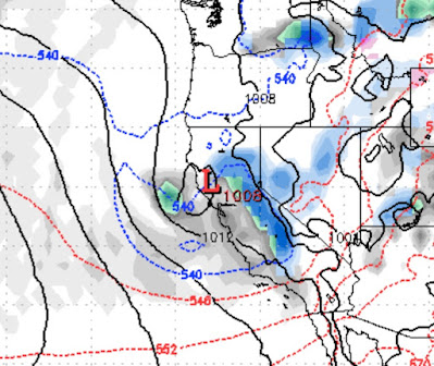
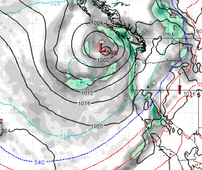
 Because we cannot rely on Mother Nature, we are tracking several very strong storms especially for this time of year. This will greatly aid in coming out of the current drought as Ma Nature cranks up her storm machine. The current storm will wind down Tuesday Night / Wednesday Morning (10/19 - 10/20). We do not expect much precipitation with this storm. Any snow will be in the upper elevations above 7,000 feet. Those levels, as always, will drop as the get on the backside of the front. This will bring beneficial moisture up and down the west coast. Notice the blob out at sea. That is going to spin into a stronger storm. The leading edge will pull up some very warm and moist air. This looks much more like a January weather pattern than October. But after the consistent record highs, many are probably relieved that winter will indeed return.  The leading edge of this major storm will be Sunday, late morning (10/24). As this storm continues to spin it will strengthen and pull up more moi

Several Fronts to Slide Down Eastern Sierra and Bring Much Cooler Temps and Light Mountain Snow

Image
The storms are getting much closer as we transition into our fall pattern and approach our rainy season. We have a couple of cold fronts that will slide down the Eastern Sierra and bring very cool temperatures starting Wednesday. A re-enforcing cold front will them come down early next week and bring our temperatures 15-20 degrees below average. Here is a look at next Monday (October 11): If you live in the mountains, expect winter like conditions as far as winds and temperatures are concerned. We do not see any major snowfall out of either of these storms, but it is still early October. We are cranking the numbers for the potential this winter and will have our season forecast in the next week or two. Stay Tuned ...

End of 100 Degree Days; Smoke to Subside; La Nina Winter

Image
We have a series of dry cold fronts that will be coming through our area in the next week or so. These will create much cooler temperatures along with very windy conditions. The winds will help to alleviate much of the smoke and we could even see several clear days. We believe the 100 degree days (which we had a record number of) are over until next year. Ma Nature is very fickle to say the least as we could see frost in some locations in the coming days. As Mother Nature continues her unforgiving forest management, we are not seeing any beneficial rains in the near future. However, we are seeing a gradual weather pattern change. Needless to say, we are hoping for an early rainy season. Although we are not ready to do our winter snowfall prediction, which last year was exactly what we forecast (pure luck), we are seeing a significant chance for a La Nina pattern to develop and stay with us for the most of the winter. What does that mean? Honestly, not much. After an incredibly dry year

Decent Storm for Sunday

Image
 It is hard for the weather gods to crank up decent storms this time of year, but if you believe all the models, we are going to see a foot or more of snow in the Carson Range on Sunday. There will be 2-4 feet at the Western Crest of the Sierra. This storm will have a cold front accompanying it. This should bring snow levels down to lake level or even below by Sunday night. We do not expect a major snow event for Lake Tahoe, but the mountains around the lake will pick up some much needed moisture. Expect much cooler temperatures at the beginning of next week as the cold front pushes through. Also, starting Saturday, expect winds to pick in the mountains and leeward valleys.  Here is the forecast for mid-morning on Sunday when we expect the precip to start: The precip will last throughout the day on Sunday and well into Monday morning. As with all storms this time of year, it will be a challenge to get up and over the Sierra, so we do not expect the Carson Range to pick up nearly the am

One More Storm Cycle; No April Fools

Image
 It is going to warm up ahead of the next and perhaps last storm cycle of this ski season. Of course this will not be a strong storm cycle this late in the season as our weather transitions from the rainy season to the dry season. Also, storms this late in the season are weaker and sometimes unable to make it over the Sierra and if they do they can die out on the east side of the crest. Having said that, we do expect some snow in the Carson Range over the next couple of weeks. Starting with early on April 6: Then another storm comes in early on the 11th: We are tracking what could be another storm for Tax Day, but we will wait and see on that one. In the meantime, conditions remain excellent all around Tahoe. Resorts will begin to close so get those last turns of the season in. I saw an interesting post that Whistler is closing for 3 weeks due to the Corona Virus. I did check the Washoe County website yesterday and there were a total of 25 cases in all of Northern Nevada and only 27 ho

High Pressure to Remain in Control for next Couple of Weeks; Slider on Monday Night?

Image
 High Pressure has moved off the coast and will be in control of our weather for the next couple of weeks ... Especially after Tuesday. The NWS is calling for a period of "moderate to heavy snow" for the Eastern Nevada valleys as a slider type system is going to shove south through our area. They are the pro's so I would keep an eye out for this. None of the models are showing this scenario so we have a faceoff between the weather models and the NWS, I guess we will see who wins. As high pressure continues to control our weather, expect plenty of sunshine and average to slightly below average temperatures for the next couple of weeks. For those snow enthusiasts (like everybody who reads this blog), we are seeing a chance for a moderate storm to move in from the Pacific around the 4th of April: Being 2 weeks out, our confidence is low but thought we would pass this on. Stay Tuned ...

One More Storm Then High Pressure Takes Over

Image
Happy St. Patrick's Day! We are tracking one more storm. This storm has stalled somewhat and will come in on the 18th and last on and off through the 20th. However, the Carson Range could be shadowed from a good portion of this event. One thing that won't be shadowed is the cooler air that will come in behind this storm. Here is a look at the forecast for Friday the 19th: The leading edge of this storm will creep in tomorrow (March 18th) and last into Saturday. We are thinking about a foot of snow for the Western Sierra Crest and 2-3 inches for Mt. Rose. It will take a few days for temperatures to recover, but it looks like this is the last storm for a while as high pressure sets up off the west coast. Conditions are excellent at all Tahoe Resorts so get out and enjoy the coming beautiful weather! Still La Nina, but not For Long We are still in a weak La Nina pattern, but it is winding down and we will move to a neutral ENSO by late spring. What does that mean? Not much for our