Posts

One Storm For Thursday; Then More Cool Dry Weather

Image
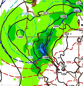
I have searched long and hard to find a reason for optimism as we go into our stormiest part of the year, but I am not seeing anything in the long range weather models that suggest we are in for a big storm until at least Christmas. Of course the disclaimer must be that conditions are very fluid this year and 3-4 week predictions should hold little, if any merit. But here is the 30 day. Remember I published this last year and it was right on, so pardon me for being a little paranoid here: The EC weather model has the Carson Range forecast for 1 inch of liquid precip between now and Christmas. That includes the storm coming in on Thursday which is supposed to deliver between .5 and 1 inch of precip. That storm has greatly weakened over the last several days. The storm track is heading north of us as our persistent ridge of high pressure is going to park right off the coast and is forecast to stay there for some time. Here is a look at the EC model for the Pacific starting late ne

Cold Storm for Tuesday Afternoon

Image
At around noon Tuesday a cold storm will drop out of the north and begin to have an effect on our weather. By 4:00 the storm will be raging with strong winds, much colder temps and even valley snowfall. This is a fast moving storm that does not have much in the way of a moisture tap and therefore, do not expect much snow. Here is the forecast for 4:00pm on Tuesday: This storm has a very poor trajectory, unless its cold air you are interested in. It will drop more out of the north than the west, which will limit moisture. I look for 5-10 inches by Thanksgiving for the Carson range. This is a very cold storm and snow to water ratios could be as high as 20 to 1. There is another shortwave that should follow the main storm on Wednesday, so that will add some minor, additional accumulation. This is a fairly typical storm for this time of year, however if we look west across the Pacific, there is a lot going on. Super Typhoon Koppu is causing havoc. I will be interested to see

Quick Storm Update, High Pressure Moving In

Image
Looking at the latest run of the ECMWF weather model the news is not good. The front is moving in and will pass through very quickly. The bulk of the moisture will stay on the western Sierra. I am looking at about .25 - .5 total liquid for the Carson Range. That will equate 3-6 inches of snow max. This front is coming in with some very cool air as well, temperatures will plummet. Any precip in the leeward valleys will be mostly snow. However, I do not see any accumulation. The bulk of the moisture will come through about 3:00 today and be done by 7:00 tonight. Here is a look at the forecast for around 4:00 today: Also, our persistent high pressure ridge will move back into place and begin blocking storms as they attempt to move into our area. I am not seeing any significant storms for at least the next 10 days. The problems is our ridge of high pressure coupled with no blocking in the upper plains to Hudson bay. This is allowing storms to move inland and continue tracking due ea