Posts

After This Storm, No Other Storms In Site

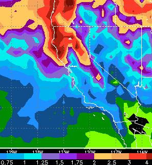
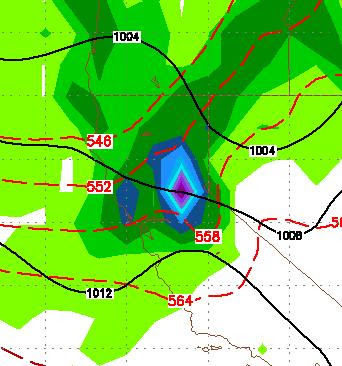
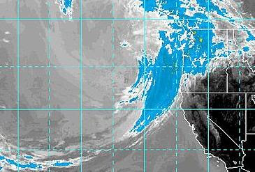
The coming storm will bring some real serious December/January like weather to the Sierra and leeward valleys. Most areas will see some snow and the Sierra will pick up 1-3 feet of snow, depending on elevation. That is up from my prediction of 10-20 inches yesterday. Unfortunately, this appears to be the last storm for at least the next 2 weeks. The models are in surprising agreement that high pressure will move in and keep the storms far to our north. I guess the golf season continues ... Stay Tuned.

One Storm Here Another On It's Tail

Image
We have a decent chance of precip for the next 3 days and if you think it is windy today, wait until Tuesday Night and Wednesday as our first moderate storm of the year approaches. Most of the action will be to our north and west. However it looks like Tahoe and the leeward valleys along the Carson Range should get some good rain. As far as snow, the NWS has issue a Winter Storm Warning for the Sierra around Lake Tahoe above 7,000 feet. Look for 10-20 inches of snow depending on elevation. When we see the mountains again from Reno, they will have a nice white coating on them. Here is a look at the EC precip totals. This is the most aggressive of all the models and shows quite a bit of precip for the area. Most of the other models are forecasting about half that. The bulk of this storm will come in Tuesday night and last into Wednesday. Looking down the road, temperatures will be much cooler, but High Pressure should settle into the area for the weekend, which should mean sunny skies wi

Near Perfect Weather To Slowly Phase Out Ahead of Stormy Pattern

Image
Hard to complain about our weather since the snows stopped in the middle of June. Since that time it has been near perfect with warm sunny days and cool nights. That pattern will not stay constant. Instead we have a series of disturbances headed our way for early next week. As I talked about in my last post, the remnants of Tropical Storm Hilery is going to mix with a trough and prime the atmosphere with moisture. That moisture will be pulled north by a couple of low pressure systems. This pattern that I see developing looks very similar to what we witnessed last March. Large storms to our north, cut off a chunk of their energy and send it down the coast our way. Next Wednesday is looking very interesting with what appears to be a decent precipitation event headed for the Northern Sierra. Take a look: Again, GFS has this storm coming our way on or about Wednesday October 5th. This will bring snow only to the highest elevations > 10,000 feet, as it will be accompanied by warm air.

Cooler This Weekend, Nice Next Week

Image
Ok, about time I got back into this thing. I know under my roof everybody is looking forward to winter. This weekend will see a weak low pressure system to our north sneak some cool and windy air into our region. However next week is looking beautiful. There have been some changes over the last few months, highlighted by the emergence of La Nina (Yes, she is back) in the Equatorial Pacific. That has caused a number of long range forecasters to predict an early start to winter, in some cases very early. Currently, I am tracking a tropical storm down off the southern coast of Baja. Hilery is packing some moisture and moving north and this could coincide with a weak trough dropping out of the Gulf of Alaska. This could be our first major weather event and it looks like October 1 and 2 is when the party gets started. The mountains should see some snow in the upper elevations above 10,000 feet. Here is a look at the 2nd of October: Ok, the models are all over the place. La Nina retu

Continued Near Perfect Weather For 7-10 Days

We will continue our run of near perfect weather for the next 7-10 days and then it is going to get really hot. Chance of rain, zero! Everybody has surely heard of the great success of the Government takeover of GM. Here is another angle that I found very interesting, enjoy:   The Dirty Little Secret Behind The New Chevy Volt: Patrick Michaels is a senior fellow in Environmental Studies at the Cato Institute and the editor of the forthcoming Climate Coup: Global Warming's Invasion of our Government and our Lives, as well as the author of several other books on global warming.  His Forbes column on the Chevy Volt is a case study in the nexus between big government corruption and big business subsidies.  Michaels briefly recaps the consumer fraud in which GM has touted the Volt as an all-electric mass production vehicle on the supposed basis of which its sales receive a $7, 500 taxpayer subsidy, and it is still overpriced and unmarketable.  Michaels notes

Unseasonably Large Cold Front Knocking at the Door

Image
Normally this blog is in hibernation this time of year, but this is no normal year. There is a very large cold front pushing down the Oregon coast that is coming our way. With this front will come wind, rain, snow in the upper elevations (> 9,500) and much cooler weather. Tuesday, Wednesday and Thursday temperatures will probably not get out of the 70's in the leeward valleys of the Sierra. Likewise, in California, high temps will by 20-30 degrees below average. Here is a look: This satellite picture is unheard of this time of year. Enjoy the cool weather while it lasts as summer is coming in full force as the jet will shift far to the north allowing much warmer air to come into the Northern Sierra. Temperatures could reach 100 by the beginning of next week in areas like Reno and Carson City. Mother Nature willing, I can now go back to hibernation. Stay tuned ...

Human Induced Global Warming Predictions Falling Like Dominoes

Image
Quick Weather Update It is going to be hot this week. It is going to be really hot next week with high's in the upper 90's or above. So if you are waiting for the warm weather, your wait is almost over.   Colorado River Flows Some amazing numbers are coming out concerning the water levels of Lake Mead and Lake Powell in Nevada/Arizona. Before we go into those numbers read this quote from the New York Times. The link to the ridiculous article is published at the end of this post: " Lake Mead has a 50 percent chance of becoming unusable by 2021, the scientists say, if the demand for water remains unchanged and if human-induced climate change follows climate scientists’ moderate forecasts, resulting in a reduction in average river flows. " The headline of the article is: "Lake Mead Could Be Within a Few Years of Going Dry, Study Finds" This article was published in 2008. What is amazing and something you find all the time in the liberal media, is