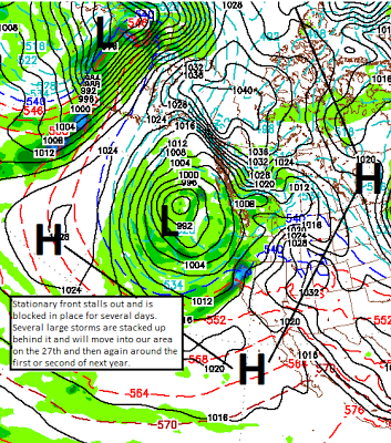
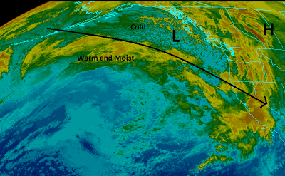
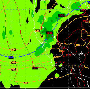
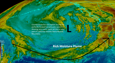
Posts

Quick Storm Update

Image
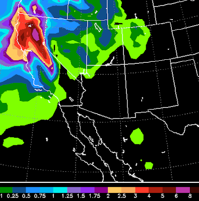
The storm is currently approaching from the Northwest with the first wave of moisture due later this morning. Here is the NAM weather model for total precip up until Monday. The models are starting to increase the amount of precip coming. This forecast is talking 8 inches for NW side of Tahoe and 4-5 inches for the entire Sierra around Tahoe. I believe lake level will pick up at least 2 feet of snow while the Sierra above 8,000 feet can expect 4-8 feet. The Carson Range should be in the 4 foot range by late Monday. For more details about the storm see my post from yesterday. Reno and Carson City will also see snow. Very difficult to forecast. The foothills above 5,500 feet should have a pretty decent snow event (12+ inches), while the valleys should pick up 2-6 inches. Again very difficult to predict how much of this makes it over the mountains. I am much more comfortable forecasting Sierra snowfall amounts. Merry Christmas!

Giant Slow Moving Storm To Slam Tahoe With Another On Its Heels

Image
Storm 1 I sound like a broken record, but the snowy pattern is going to continue. The first of two very large storms is knocking on the door right now. It will bring very windy conditions this afternoon into this evening. Wind prone areas of the eastern foothills could easily see 70mph winds. By tomorrow the precip moves in. This storm is moving very slowly, so the models are predicting a major snow event for the Sierra and Leeward Valleys. It is going to snow in the Sierra, non-stop, from tomorrow morning through Monday afternoon. Much of that snow will be very heavy at times. Here is why, notice the blocking that is occurring forcing the front to remain stationary, remember to click on an image to enlarge. Needless to say, mountain travel this weekend should NOT be attempted! Also with the copious amounts of snow on a very solid base, avalanche dangers will be high and you should check the Sierra Avalanche site. A link to that site appears on the right side of this web page.

Snowy Pattern Continues

Image
Not much has changed since I last blogged. I will try to pinpoint the powder days that are upcoming, there should be many. First of all we are moving deeper into a very cold snowy pattern. I have charted it out. Basically, we have a blocking ridge of high pressure that is dropping Arctic Cold into Central Canada (See post on Arctic Oscillation). That is forcing a large cold air mass down through our area that is tapping into a very wet moisture tail. Remember, you can click on any image and get a much bigger picture. This afternoon and this evening we will see more snow coming to the Sierra. It will tapper off later tonight and leave between 2-6 inches in the Sierra and Carson Range. Probably the lower amount in the Carson Range (Mt. Rose). Tomorrow should be great, just like today. Perhaps a bit more pow. Now the fun gets started. It looks like near constant moderate snowfall in the Sierra and Carson Ranges starting Sunday night and lasting until Tuesday afternoon. I look for

Stormy Pattern to Return Starting Tomorrow Night

Image
I apologize for my absence. I have been very busy with my day job and since the weather has been tame there was no need to blog. However things are changing. Starting with a nice little storm for Tuesday, Wednesday and Thursday. Tuesday will usher in some winds while Wednesday will bring precip. Wrap around moisture could be on tap for Thursday and this is a much cooler storm and will be all snow. As the cold front comes through on Wednesday, snow levels will drop to the valley floors. An area of wrap around moisture could affect the 395 corridor south of I-80 with up to 6 inches of snow late Wednesday into Thursday. Here is a forecast for Wednesday midday: We are about to enter a very stormy pattern as a NW flow will come into the area and bring with it a series of storms. I am impressed with the storm heading our way for Sunday: Next week the pattern looks to sustain as another storm is coming our way for Wednesday the 19th: This pattern should bring major snow to th

Storm Update - Snow Level Holding at 7,500

Image
Wave 2 of our 3 wave storm is all snow above 7,500 feet according to the NWS. Snow levels may actually drop down to 7,000 feet as this wave progresses. Mt. Rose has already picked up between 12-18 inches of snow and that amount should increase to around 2-3 feet of very wet snow. Perfect to form a base. That is the good news, the bad news is that the NWS believes the next storm, which is even larger than the last two,  will have a snow level between 9,000 and 10,000 feet. Areas like Slide Mountain and the western Sierra Crest are going to get 5+ inches of precipitable water out of this storm. I am not going to guess what that will do to the snow but it is obviously not good. We will just have to see how it shakes out. In the meantime, the Truckee River is going to flood with all this moisture. I believe minor flooding, but you should be prepared. All small streams and creeks have the potential for flooding, so if you live near White's, Galena, Thomas or other creeks, be prepared. T

Storm Update - Snow Elevation Forecast Drops

The dangerous winds for the Sierra Foothills on the leeward side will remain in effect. However, the NWS is now talking about those winds being strongest well south of Reno. My original analysis was for the possibility of 100mph plus winds in wind prone areas like Arrow Creek. I think we will see winds up to 100mph but the precip will shield us from the winds going any higher. Those winds will be tonight so hunker down! Snow elevation forecasts now are calling for snow above 7,000-7,500 feet. If this happens, the entire Mt. Rose ski area will be open by Monday as they will see in the neighborhood of 5-10 feet of very wet snow. That is great news, but often times God does not include the NWS in His forecast plan, so keep doing your dances, prayers or whatever else may work. Stay Tuned ...

Five Days of Storms Starts This Afternoon

Image
The series of storms I talked about in my last post is knocking on the door right now. Here is what to expect through the weekend: Starting this afternoon a storm will move in from the south and west and bring precipitation to the area especially the western Sierra. Snow levels look to be about 7,000 feet for this one. This is the weakest in the bunch and will move out quickly. I expect 6-12 inches of snow for Mt. Rose, while the Western Sierra areas could easily pick up double that. Forecast for late tonight: Larger system moves in very early Friday morning. This is a much warmer system that taps into the subtropical jet. Expect damaging winds on Thursday night / Friday morning. This will spill heavy rain into the valley and the NWS is concerned about possible flash flooding. Snow levels will be at 8,000 feet or higher. Where it snows there could be a possible 2-4 feet. However it looks like this will be rain for most Tahoe areas and possibly half of Mt. Rose too.