Most October Precipitation in 20 Years, Just Off the Coast
... And like that, Mother Nature flips a switch and we go from some of our driest weather in some time to some of our wettest weather in October, ever!
There is a massive storm that is going wreak havoc on the northern half of California and Western Nevada. This storm is going to produce copious amounts of precipitation. That precip will spill over into the leeward valleys of Reno and Carson City and deliver some much needed rain. Maybe too much as flash flood warnings and watches are out for the entire area.
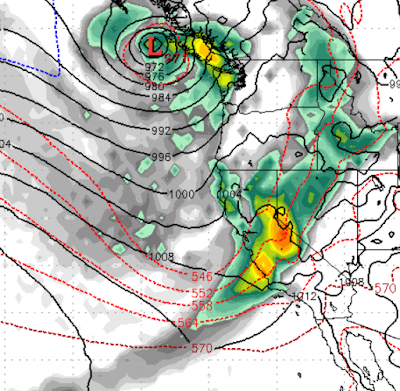
This storm will pull up very warm air and tap into sub-tropical moisture. I believe the modern acronym is that we are about to experience an AR event (atmospheric river). Very unusual for October. Here is what the EC see's in the way of timing.
Friday October 22nd Noon: This is the weakest of the waves of moisture heading our way.

There will be a window of on again off again precip throughout tomorrow (10/23), then very early Sunday the big stuff comes in:
Sunday October 24th 5am:

This is just the leading edge of a very powerful storm. Notice the moisture tail on this storm as it pulls very warm, moist air up from Hawaii.
Sunday October 24th 11am:

As the storm stalls out, a major atmospheric river sets up and the water literally flows to Northern California and Lake Tahoe
Sunday October 24th 5pm:

The storm has barely moved over the last 12 hours and continues to dump major rain/snow as that rain begins to carry over into the leeward valleys of Nevada.
Sunday October 24th 11pm:

Monday October 25th 5am:
As the storm moves north the precip actually dips a little south, producing smiling faces in Mammoth.
Monday October 25th 11am:

Central California is now in the precip bullseye!
Looking forward much lesser amounts of precip will continue to hit Tahoe as the cold front comes through.
Snow Levels and Amounts
This is so hard to predict. We know initially, snow levels will be around 9,000 feet. They will slowly drop through the event. By Monday they will be below 6,000 feet. We believe around mid-day Sunday the base elevation of Mt. Rose will be getting all snow. We are still looking at 3-5 feet of snow for Mt. Rose and 10+ feet of snow for the Sierra Crest west of Lake Tahoe. The following chart is showing over 12 inches of liquid precip for the crest while cities like Reno and Carson could see 5-7 inches of Rain. That amount of rain is our annual average, so we are not too confident on that number, mostly because it seems impossible ... but let's not forget who's in charge: Hint: It aint us.

Next Storm on Tap
Hard to believe we are talking about this in October, but it looks like another storm could be on tap for Halloween. Right now it is too early to tell as the models are not in alignment quite yet.
Stay Tuned ...