Storm Machine to Crank Up Next Week; Winter Outlook
Storm Watch
Today's storm is nothing but a small teaser for what looks to be a major winter storm in about 8-9 days. We are tracking a major storm that both the EC and GFS weather models are in very good agreement. Here is a look at the forecast for the 15th of November:

If this storm holds together it will begin somewhere late on the 13th and could bring copious amounts of precip to the Sierra and Carson Ranges of Lake Tahoe. We believe this will be all snow for Mt. Rose as snow levels will start high but quickly come down.
The following is the forecasted precip for the next 10 days.

Needless to say, if this hits as all snow, Mt. Rose should be able to open quite a bit of terrain as we are talking about upwards of 4 feet. Let's hope it does hold together as we are seeing a ridge in the jet over our area moving forward, not unexpected this time of year.
Season Watch
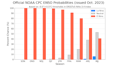
We have been very lucky the last several years with our season snowfall predictions. We were the only site that predicted the possibility of well above average precip for last season. This year we have transitioned into an El Nino from last year's La Nina. We use the ENSO for long range predictions and one of the most reliable predictors is El Nino.
The following chart shows just how bullish NOAA is on this winter having a moderate to strong El Nino. It could begin to weaken by March but by then, we should be deep in the snow.
Our best guess is that the winter of 23/24 will have above average precipitation, with a chance of significantly above average. We are looking around 380-500 inches for the Carson Range and more along the Western Crest of the Sierra. This winter will not be anywhere near as cold as last. El Nino trends warmer for our area.
Cross your fingers, we may be off to a good start in just over a week!
Stay Tuned ...