Posts

Next System Shifts North To Tahoe

Image
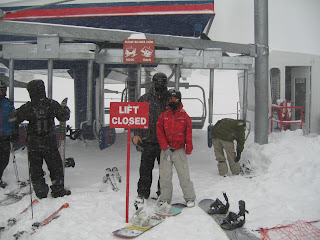
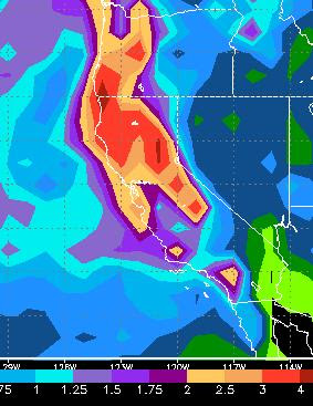
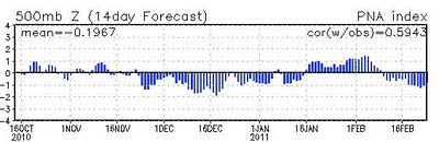
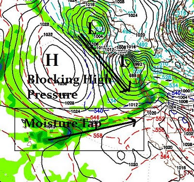
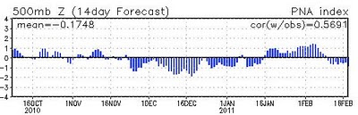
Weather Update I talked about the 2nd system a few posts ago. Initially the models had that system shifting south and just grazing us here in Tahoe. That has changed. That system will move inland and hit the Tahoe area with more heavy snow starting Thursday around noon and lasting through Friday. The system does not have the winds associated with it either. NWS is considering posting a heavy snow warning for the Tahoe Sierra. After a two day rest, late Monday another system should move into the area. The models are all over the place with this one. I am thinking next Tuesday could be another heavy snow day in the Sierra. The potential exists for another major winter storm. We will stay in this wintry pattern for at least the next 15 days so conditions should be near perfect. Today's Conditions I ventured up the mountain today and it was an epic day. I went to Mt. Rose Ski Tahoe. They had both their high speed lifts running all day long. Very few people made it up as the pa

Storm Precipitation Total Update

Image
The models are leaning toward an increase in precipitation. The party gets started tonight. Here is an updated look at storm total precip forecast through Saturday: There is a large area north of Tahoe in the 6-8 inch range. The northern parts of Tahoe could be looking at nearly 6 inches, while south of the lake is looking around 4 inches. That should translate to 3-7 feet from south to north Tahoe, over the crest. This storm has increased in size and intensity. Dangerous winds for the leeward areas of the Sierra (Arrow Creek, Galena, Washoe Valley) will increase as the storm approaches. Right now it looks like Reno could get between 1-2 inches of precip. I am guessing that the foothills may pick up as much as a foot of snow starting very late tonight. If you wake up tomorrow morning and it is not totally white, then we dodged the bullet in the valley and were shadowed by the Sierra. However, I am guessing this thing will spill over and bring at least moderate snow (3-5 inches) to

Strong, Cold, Wet and Windy Storm Approaches - Start of Two Stormy Weeks

Image
The storm we have been talking about is on our doorstep and poised to hit hard. This is a large storm with very strong winds and an ample moisture tap. Here is what EC believes we should have in the way of liquid precip by Saturday:   Tahoe is very close to the bullseye. This model is looking at between 2.5 and 3 inches of precip. Because of the cold nature of this storm, that should translate to 2-4 feet of snow coming our way. Here is the timing of the system: 8:00pm Tuesday night - First Big Wave   5:00am Wednesday Morning - Storm Continues To Dump 12:00pm Wednesday Afternoon - More Dumpage 3:00am Friday Morning - Next Storm   The Friday storm will be cutting further south, but we will still get a piece of it. Looking ahead, Monday (2/21) and the following Thursday (2/24) are looking stormy as well: Monday 2/21 - Another Storm Forms and drops in   Thursday 2/24 - Chance for Larger Storm    I will keep a close eye on next week's storms ... Stay Tun

Still On Track For a Major Mountain Snow Event Next Week

Image
The models are pretty much in agreement and confident that we will have a snowy Tuesday, Wednesday and Friday next week. Although this storm is fueled by a lot of warm, moist air, snow levels will remain in the 6,000-7,000 foot range which means all snow for most Tahoe Resorts. Looking forward, it appears as though the blocking high pressure system to the north will remain in place for at least another week and allow at least one other storm to pull moisture around the high and bring it from Hawaii to Tahoe. Therefore this could be a 2 week (or more snow event). Looking any further would be nothing but wishful thinking but my gut tells me that we are about to enter at least 2-4 week stormy period. The NOAA PNA forecast seems to be suggesting the same thing. It is also suggesting that the storms may even get larger, take a look:   Remember, as the PNA goes negative, we get stormy. If you want to follow our storms since October, take a look at the chart above. It looks like we are g

Pattern Change This Weekend, Followed By Solid Week of Storms

Image
Let's look at how our pattern change will shape up and why I believe this will be a major weather event for Northern and Central Sierra: There are two decent size storms developing in the Gulf of Alaska. These two storms will work their way down the coast. Meanwhile, a line of moisture from the subtropical jet is setup from Hawaii to the Northern California Coast. The key here is a blocking ridge of high pressure that will prevent the moisture from moving north. This moisture tap will wrap around the ridge as it gets sucked into the two storms as they move further south. These two moderate storms will merge and form one giant storm. That storm will hold together for a day or two and split. Some of the energy will go onshore in southern BC. The other energy will move down the coast and strengthen. It will pull copious amounts of moisture right into Tahoe and dump what should be an impressive amount of snow in the Sierra from Tuesday - Sunday (2/15 -2/20). This should bring quite

For You Professional Meteorologists, There Is Still Plenty of Room On The Bandwagon

Image
I apologize for the headline, but right now we are just waiting for the pattern to change in a little over a week. The good news is that I am not the only one talking about this. The NWS and NOAA have hopped on the bandwagon. I should not be so smug. These guys know a lot more than I do, and get paid to forecast the weather. When they are wrong, it is a big thing. When I am, nobody cares. It is a real risk for them to talk about a pattern change in 8-10 days. But that is also a sign that it is coming and the POW will return to Tahoe. First let's take a look at the PNA, remember a negative number is a good indicator of a stormy pattern: First Shot At Timelines This is a very similar pattern to what we saw in December. A massive storm will drop out of the Gulf of Alaska and tap into a very moist subtropical jet and should dump copious amounts of moisture right on Tahoe. As it looks now, we are in the bullseye. Sunday, Feb 13th is when the fun gets rolling as the first wave of

Tailgate Weather This Weekend - Storms Return in 10-12 Days

Image
Above Average Temps For The Next 10-12 Days  More warm temperatures are headed our way for the weekend as the grills will be in full force on both Saturday and Sunday at the slide parking lot on Mt. Rose. All non-mountain golf courses will be open by Saturday. Can you say Spring Fever? Enjoy this nice stretch of weather. Stormy Pattern Returns Around February 12th or 13th Many signs are pointing to the mountains returning to a stormy pattern around the middle of February. Having said that, storms in February are not as strong as storms in December so do not expect a repeat of earlier in the year. Here is a picture of earlier in the year: Truly some epic dumpage. Having made my disclaimer, remember that La Nina is famous for large storms followed by long periods of mild weather. Right now the models are just now picking up on this change. The EC model has this for the 12th, notice the approaching storm from the northwest: This should be the first in a series of storms. GFS i