Posts

Storm Track Moves South, Expect a Stormy Week

Image
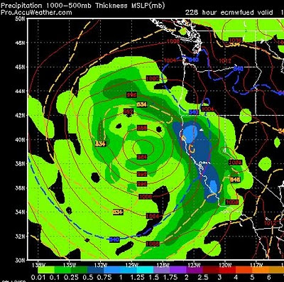
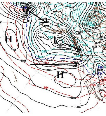
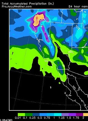
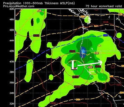
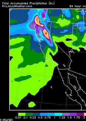
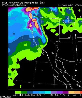
A series of storms will move north of the area but will affect our weather and dump snow in the mountains. Right now the EC weather model has 3 separate storms coming in for next week starting on Monday and lasting at least through next Sunday with very few breaks. Each of these storms moves progressively further south and EC is forecast the following for next weekend:   This is a pretty big storm for mid-March and it is tracking south, right through central California. EC is the most aggressive of the weather models for this forecast but all models are pointing toward a very stormy week. GFS has the party starting late Sunday night and shows mountain snow for the next 5 days with virtually no break. Our ridge to the south has not moved further south, but broken down completely and is reforming to our north which oftentimes means these types of stormy periods. La Nina generally means an early spring. Somebody forgot to tell that to God! Spring will come in like a lion. This patt

We Are On The Edge Of The Storm Track

Image
Here is our current condition: Blocking High Pressure has set up to our south and west. This causes the storms to track north of Tahoe. Currently the models have that blocking high moving slightly south, which puts us right on the edge of the storm track. If it moves a little further south than expected, we can expect another storm cycle to start up next week. If it remains or moves only slightly south, we can expect just glancing blows that bring us wind but very little if any precip, which is that typical Sierra spring pattern I talked about last post. Mountain Snows Next Week Both GFS and EC have a series of storms that will move north of us, but not too far north where we only get the glancing blow.  Here is a look at next Monday's forecast by the GFS weather model. Notice the storm is to the north, but the moisture is able to penetrate the outer rings of the high pressure system: This makes forecasting weather very inaccurate at best. Suffice it to say, however, stor

Prepare For Sierra Spring Conditions

The last storm in the cycle has now moved through the area dropping close to a foot of snow on Slide Mountain and leaving slightly more west of the crest. This is exactly what we expected as the models nailed another one. As the backside of this storm drops down the cold front, winds will continue, however by Tuesday afternoon a ridge of high pressure will move into the area bringing sunny skies and much warmer temps. Expect 60's by Wednesday. Looking forward, there will be a series of glancing blows of systems that are being pushed to our north. Those glancing blows will bring wind and little if any precip. Most will drop the temps 5-10 degrees and bring windy conditions for a short period of time before they recover ahead of the next system. This is typical of spring in the Sierra. Most valley snow is already gone and the foothills will continue their melt through the weekend. That means expect golf courses to start opening up again, which of course means ski in the morning, go

Quick Update

Image
Sunday/Monday Storm Not much has changed since yesterday's post for the storm coming Sunday and Monday. Both EC and GFS have this thing coming in Sunday afternoon and lasting through Monday, with the bulk of the precip very early Monday morning. Both models have downgraded the amount of precip associated with this storm to around .5 to 1 inch of liquid precip for Slide Mountain and double that for west of the Sierra Crest. The NAM model is talking about 1 inch for the Carson range which is the most optimistic of the forecasts. Therefore, unless something changes drastically, expect 3-12 inches of snow at Slide Mountain by Monday morning. Here is the NAM precip forecast through Monday:   As you can see, most of the action is on or west of the Crest. Next Weeks Forecast I hate to be the bearer of bad news, but it does look like this storm cycle is winding down. High Pressure is moving in to our west and south. These ridges can be stubborn and difficult to move. When they cam

Sunday's Storm Will Move Directly Over Us

Image
The storm for Sunday that I have been talking about in my last couple of posts has slowed somewhat and will probably not hit until later in the day. That storm will track right over us. That means as the storms moves by, it will pull down cold air from the north. Conversely, as the storm approaches it will be bringing up warm air from the south. That is due to the counter clockwise rotation of the low pressure system. Take a look at the EC forecast for Sunday afternoon, followed by the GFS forecast for the same time: EC Forecast Late Sunday Afternoon GFS Forecast, Late Sunday Afternoon   You can see that GFS has the storm quickly moving past us and then stalling out bringing cold snow to the area on Monday. EC has the storm hitting later, with the precip on the front end, which of course would be mean heavier, wetter snow. Regardless, both models are calling for only about an inch of precip in the Sierra and about half that for the Carson Range. My initial forecast is 4-12 in

Storms Still On Track, Cycle May Intensify Next Week

Image
Today and Tomorrow's Storm The storm that I have been talking about for a couple of weeks is here and is following just what the models have forecasted. It has moved north which still leaves plenty of precip for our area. It should be snowing in the Sierra for at least the next 24 hours. The crest will pick up between 1 and 3 feet. The Carson Range (Slide Mtn) should pick up about half of that, 6-18 inches. This is because of a string south wind that is keeping the bulk of the precip in the Sierra. Here is an updated look at precip totals through Friday: Sunday's Storm Sunday's storm is also on target for what I talked about in my last post. It looks like a shot of pretty intense snow starting Sunday morning and lasting through the day. Here is a look at the forecast for very early Sunday morning: This is also a warmer storm that should bring rain to all areas of the valley. Snow levels will probably be in the 7,000 foot neighborhood, which means rain at lake l

Warmer Storms Approach Tahoe

Image
  Tuesday and Wednesday (3/2, 3/3) The Arctic air has cleared the area making room for a much warmer storm to hit the area starting late on Wednesday and lasting through Thursday. As I wrote in my last blog, the bulk of the energy in this storm is heading north of us. This storm was born in the south and does carry significant moisture. I am pretty comfortable with the time frame of when this storm is going to hit. However, I would be remiss to not mention that the EC model has this storm hitting about 24 hours later on Thursday night. How much precip can we expect? That is a good question. Right now it looks like a quick hitting event that will produce snow at or above Lake Level. Any moisture for the valley will come in the form of rain. However a strong south wind may well shield the valley from any precip. It will be windy. Slide mountain will also be affected by this wind as the snow totals will be less than the Sierra Crest. Here is what the NAM model see's for total precip: