Posts

Ready or Not, Here it Comes

Image
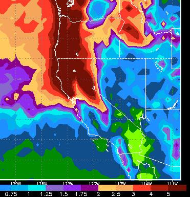
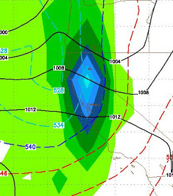
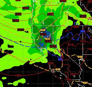
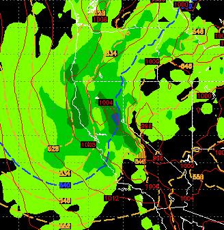
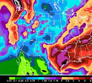
We have been talking for about 3 weeks or more that conditions are becoming favorable for a change to a prolonged stormy period. Well here it comes. Let's not mess around. This first image is the total liquid precip forecast by the EC weather model for the next 10 days: 10 Day Precip Forecast Many areas around Lake Tahoe are forecast for better than 5 inches of precip. There could be more. There is a ton of moisture to work with as MJO does its thing. The determining factor is how big will the storms be that drop out of the Gulf of AK? This next chart is almost a carbon copy of last year at this time. It is also a Tahoe skiers dream. Our ridge of high pressure has been well west, while another ridge has setup west of Hudson Bay. That creates a storm corridor directly into Northern California. This should produce a series of storms that should come one after another. The party starts Tuesday night when the snows begin. This pattern has the potential to go 2 weeks or mor

Spring Coming To an Abrupt Halt

Image
Short Term If you enjoyed the last couple of days, then you will enjoy tomorrow as temps will climb close to 70 in Reno and Carson City. Tomorrow night will bring in a fast moving very cold front. With it will come all the winds and at least some snow for the Sierra. Precip with this front may start as rain below 8,500 feet but will quickly change over as the front approaches. This storm is moving fast but we can expect 2-6 inches for the Carson Range and possibly a bit more. Tuesday and Wednesday will see high temps barely make it out of the 40's in the leeward valley and not crack the freezing mark in the Sierra. Another warm ridge of high pressure will move in for Thursday. A possibility of another system comes in for the weekend, but the models have that moving just north. Long Term Okay, I have been talking about conditions being ripe for winter weather. I believe the storm that I discussed in my last post, for the 12th will come into our area and give the Sierra a decen

What's Next?

Image
Ok, that was a great week for winter as all of the Sierra around Tahoe was blanketed with at least 4 feet of snow and some areas as much as 8 feet! Coverage out there is much better, but what's next? If you believe the NWS, nothing. Not for a couple of weeks. However, sometimes they make their calls based solely on weather models. They were caught with their pants down this week as were the weather models. The EC weather model is predicting a couple of good storms in the next 10 days or so, starting with next Tuesday/Wednesday. However GFS has everything staying well to our north. Here is a look at a storm with ample moisture that is being forecast by the EC weather model. The EC was closest to this past weeks surprise: 3/12 - Is this being affected by MJO moisture?? MJO has settled into phase 3. What the heck does that mean? That means that it is in a very good position to have a very moist impact on our weather. The models have certainly not picked up on this, however

Quick Update - Storm Strengthens Considerably

This is just a quick update to my post earlier this morning. The storm has actually strengthened and will hit the Tahoe area with a bulls eye. It will then move slightly south and stall. That means snow and lots of it for the entire Tahoe area. We are now talking about 3-5 feet for the Sierra Crest and 2-4 feet for the Carson range by mid-day Thursday. At lake level they will receive more than a foot of snow. The Reno and Carson Valleys will mostly be blocked out, but should pick up 1-3 inches tomorrow morning around 6am lasting until about 10am. The foothills could pick up another 3-5 inches. The big news on this storm is the prolific moisture. Similar to what happened on Monday, these last two storms are picking up copious amounts of moisture. They are rising above the High Sierra, condensing quickly and dumping. After midnight the Sierra could well see snow amounts in excess of 3-4 inches an hour for about 12-18 hour period. Again this will be all snow at all Lake Tahoe elevations a

Heavy Snow Starts Late Tonight and Lasts Through Wednesday

Image
Short Term The Sierra is in the cross hairs of another larger storm that will start to make its presence felt later this afternoon and last through the day tomorrow with lingering snow lasting through Thursday. This storm is larger and has a much better moisture tap than yesterday's. Here is what we are looking at very early tomorrow morning (2/29): Large Storm Coming to Tahoe Sierra This storm will have a more profound affect over the Western Sierra than the Carson range. However I still expect a heavy dose of snow for the Carson Range. Right now we are looking at 2-3 feet for the Sierra Crest west of Lake Tahoe with 1-2 feet for Slide Mountain and the Carson Range. This should be all snow from the lake level on up. Incidentally, we are looking at 6-12 inches around the lake. Mid Term We are still looking at the potential for another storm next week, the question remains when? The models are not in sync on this one but the consensus is some time around mid-week expect ano

Winds Dying as Conditions Turn More Favorable for Snow This Week

Image
The winds are dying and the mountains should open up completely this morning as this strong cold front has passed through the area. The NWS is cancelling all wind warning by early this afternoon. Conditions are turning much more favorable for a series of small storms to hit the Tahoe area starting Sunday night with a better storm coming on Wednesday and Thursday. Then early the following week, the storm door appears to be opening a bit wider as another larger storm is headed our way. Here is the EC look at the storm slated for March 5th: Here is a look at precip through the 5th. Amounts are slightly understated because the aforementioned big storm will be just beginning to hit our area: I am thinking about 1-2 inches of liquid precip by the 7th of March which of course should make conditions better. Despite the lack of snow this year, conditions at Mt. Rose are quite good. We just have not had the pow that we have become accustomed to in years past. I am still looking for eve

Quick Update - Going To Turn Cool and Stay Cool

Image
Current Through Next Week A series of systems are headed our way. Unfortunately they are not packing enough moisture to bring us any significant precipitation. They are packing cold air and wind. They will continue to re-enforce through next week which will bring us our worst week of weather this entire winter ... I define bad weather as being cold, windy and no precip. Strong Winds Forecast For Friday Night The pressure gradient is just right for this next system, which comes through tomorrow night to whip up some serious winds, as much as 120 mph for the Crest. Do not be surprised if the foothills and other wind prone areas of the valley see gusts in excess of 100mph, so get your basketball hoops and other yard items under cover or they could end up getting blown in the valley. Long Range MJO has stalled, but not all is lost. There are a series of events that lead the TWB to believe that we are still in for a wet March, but probably not starting until the 2nd week. Again we ar