Posts

Don't Count El Nino Out Yet as Winter is Coming Back

Image
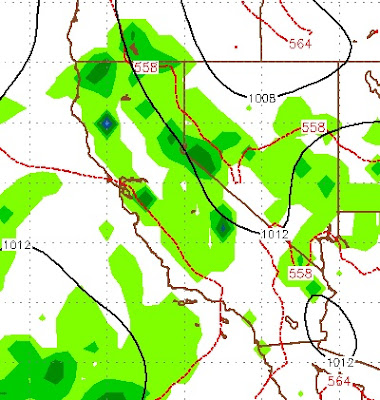
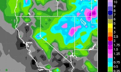
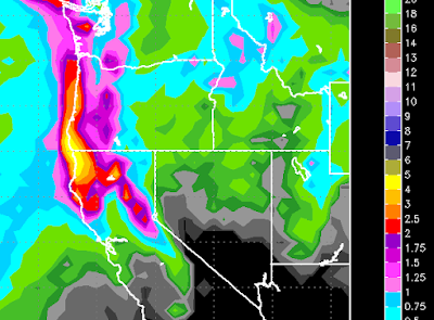
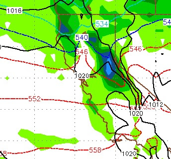
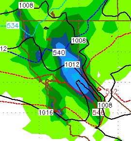
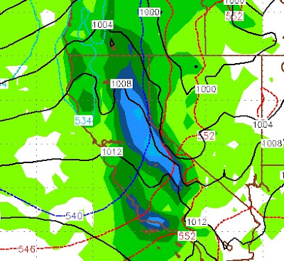
Winter is going to make a comeback over the next 7-12 days at least. A small storm is coming in from the south and will actually deliver some much needed rainfall for Southern California. Although, I do not see a major rain event, they will take what they can get. That southern storm will work its way north into the Tahoe area and produce rain and upper elevation snow. Then, a larger storm will drop down out of the north and remind you of January around the middle of next week. This storm will bring beneficial rains to Northern California and snow to the Western Crest of the Sierra. Interestingly enough, the models are not in agreement here. The GFS is more bullish on both storms producing precip for California. The EC is has lighter amounts and later timing, but believes the Carson Range and the leeward valleys will join in on the party. I usually side with the EC as it has been the more reliable model. Let's start with the GFS for late on Friday: This storm is centered

Cold Slider Comes Tonight

Image
The weather models are moving our slider slightly further west on its trajectory to Tahoe. That could bode well for more moisture for the storm to work with. I was not bullish on this storm yesterday. Today I am a little more optimistic. The storm comes in tonight and will stick around through Tuesday. The impact of this storm will be felt on the eastern side of the Sierra Crest and the Carson Range. Perhaps the biggest impact is the cold front that is coming with this storm. Temperatures will be much colder through most of the week. Nobody is trying to predict snowfall amounts. I am going with 6-18 inches for the Carson Range by Tuesday night. Slightly more for the eastern side of the Sierra Crest. Here is a look at the Precip forecast by the EC weather model: Dry weather follows through the week. Stay Tuned ...

Storm Update

Image
The timing has changed since our last post. We are now looking at a minor event for Tahoe late on Monday night. I believe there is a possibility for 4-8 inches of snow at Rose. Northern California will pick up another nice dose of rain. However, this system is small and weak. Looking ahead, our persistent ridge if high pressure moves in and begins to dominate our weather for at least the next week. Here is a look at the precip forecast for this next storm: As you can clearly see, some beneficial rains for Northern California.The Carson range could get up to an inch of the liquid precip, which could translate into around 8 inches of snow. It is going to get windy as the storm moves through, but I think the lifts will spin Monday morning and Tuesday morning as the timing of the storm and winds appears to be late Monday into very early on Tuesday. Winds will pick up all day Monday as the storm approaches and then die down as the cold front moves through. Stay Tuned ...

Small Storm for late Sunday, Dry and Before and After

Image
The EC and GFS weather models have a small storm on tap for late Sunday. This will usher in cooler air. I doubt there will be any effect on the Carson Range as the later we get in the year, the weaker the storms become. The EC is more bullish on this storm. Here is a look at the forecast for late Sunday afternoon: If this holds together, we could get come spill over the crest, but I am not pinning my hopes on it. After this storm moves through, high pressure will dominate for at least the next week. Stay Tuned...

Storm Update

Image
As storms continue to move into Northern California, they slide south, not generating enough energy to make it over the Sierra. Our two best chances for snow come Sunday morning around 10:00 am and then very late on Sunday night through Monday morning. I would say the storm tomorrow morning has the best trajectory to make it over the Sierra and have an impact on the Carson Range. Just for comparison sake, the GFS does not see any wave coming late Sunday night into Monday, while the ECMWF model has the following for Monday at around 4:00am pst: When we have this divergence in the models what usually happens is something in between. In that case look for light snow Sunday night through the morning on Monday. All models have things drying out for at least the next 7 days and then we may be entering another storm cycle. Stay Tuned ...

6 Days of Storms Start Today

Image
A series of storms will move into California. Beneficial rains will make it further south. This time, the Central Sierra appears to be in the Bullseye. That is until Monday. Before we get into that, these storms are moving out of the north. For the most part they will stay on the other side of the Sierra as they move south through California. However, we will pick up some precipitation. Between now and Monday I expect about 12-18 inches for the Carson, double that for the west side of the lake and more the further west you go. Back to Monday; This storm will also fall out of the north. It has a much better trajectory and I see it being a decent event for the Carson range and all of the Tahoe Basin: The above picture is the forecast for very early on Monday morning. this should stick with us for a good 12-18 hours or so and bring about an inch and a half of liquid to the Carson range and perhaps triple that for the Western Crest. Here is the precip outlook for the entire ev

Storms Stacked For Next 10 Days

Image
We do not like to look back at the weather, but these last two storms proved to be somewhat confounding. They just could not get over the Sierra. That meant enormous rainfall totals for Central and Northern California and about half of what we were expecting in the Carson Range. After my wife told me how wrong our forecast was, I simply replied to her that God always has the last say. It's His machine and only He knows how it works. I think tonight's storm should be the best of the three. This is another massive storm that should better handle the rain shadow created by the Sierra Crest. Here is a look at the forecast for tonight: This storm will be all snow for the Carson range and should produce snow all the way down to the valley floor. There could be a decent window tomorrow morning for the winds to die slightly and allow the lifts at Rose to spin. I think we will get from 1-2 feet of additional snow up on Rose so it will be quite a morning if the winds allow. The