Posts

First Good Storm of the Season Starts Monday

Image
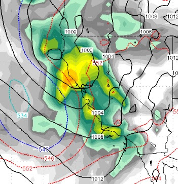
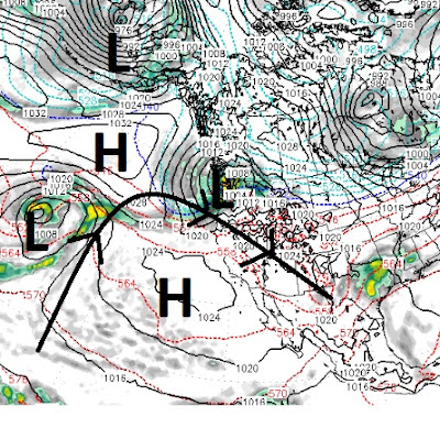
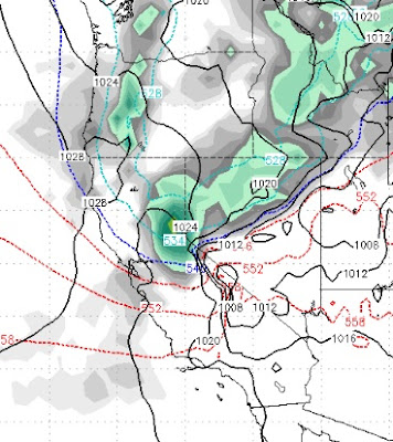
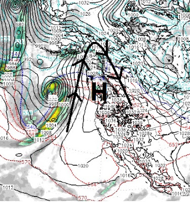
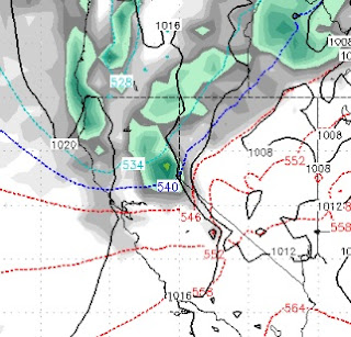
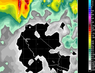
As mentioned in our last post, our first decent storm of the 2018 begins late Monday, should bring decent precip for most of Tuesday and clear out on Wednesday. High pressure builds in behind the storm, but we feel as though that will be short lived and our next series of storms should come about mid month. These past two storms were exactly as advertised. The next storm will come in warm and eventually snow levels will drop. Again, the big winner on these sub-tropical storms is Mt. Rose with it's high base. Here is a look at the forecast for very early Tuesday morning when the largest wave of precipitation hits the area: At the risk of sounding like a broken record, our forecast has pretty much remained the same for the last five days. Here is the precip outlook. This storm could come in as high as 8,500 feet but will quickly fall below 8,000 feet. We look for Mt. Rose to pick up between 18-36 inches by Wednesday morning: Not bad for this year, but nothing like what

Major Pattern Shift Begins Wednesday Night

Image
We have been locked under this coastal ridge of high pressure for weeks now, but as with all things related to weather that is about to change. The change begins slowly on Wednesday night with a weak system coming from the south. Although this system has plenty of moisture to work with, it is too weak to expect anything of significance. We are much more impressed with what starts around Friday at noon and could last up to 30 hours: Here is the forecast for early Friday Morning: Again, this is another weaker system, but does have some potential for precip. Both these system are going to be very warm with snow levels starting around 8,000 feet or possibly slightly lower. Mt. Rose will probably be the big winner again. We are tracking a storm for just over a week from now that looks very positive. It has cold air, energy and moisture with which to work. Usually that combination can usher in much needed heavy snow for the Sierra. Here is a look at the forecast model for a week

Slider Will Usher in Cooler Air; Coastal Ridge Digs Deeper

Image
The cold front we talked about last post is right on time and we are sticking with 8-16 inches of champagne powder for Rose. The deeper the less likely for skiers and riders to break through and scrape the crust underneath. I am fairly confident we are looking at a good 10 inches and if things go just right up to 16 inches. Then the ridge digs deeper. The coastal ridge in the jet is causing storms to go well north of us. This storm for tomorrow is due to that ridge flattening out. Here is a look at tomorrow: One sneaky little trough in the jet is going to allow this moisture starved slider to drop in straight out of the north. However, there is a substantial cold front associated with this storm and snow ratios could hit 15-20 to 1 depending on the timing of the moisture and cold air. The above graphic shows the ridge of high pressure in jet stream. This is causing all weather to move north around the ridge and will keep us high and dry for some time, unfortunately. Here is a

Finally, Changes in the Forecast

Image
With our ridge of high pressure getting pushed slightly west, that opened a very narrow door for what we call a slider storm. That is a storm that comes from the north and east and slides down the leeward side of the Sierra. Usually, these storms have very little moisture but they always bring cold air. In this case, we finally got some winds in the valley to change the air and clean it up. That was the first sign that we are starting to see a pattern change. The next sign will come this Wednesday in the form of an actual storm. Not a big storm or even a moist storm, but a storm nonetheless. Although this storm will come from the north and west, it will be more north than west and will bring in even cooler air. Here is a look at the forecast for Wednesday @ noon: What we like to see is for these storms to tap into an active moisture plume from the south and west. As you can see this storm does not have much moisture to work with. Here are the forecast precip totals: This wi

Large Ridge of High Pressure to Continue to Dominate our Weather

Image
A very large ridge of high pressure will continue to dominate our weather for the next 5 days. Around Thursday that ridge will begin to flatten which will allow unsettled weather and minor troughing to take place just before next weekend. We could even see an inside slider, but at very least we will see some wind make it down to the valley floors and mix up what will become some very poor air quality. If you live in the mountains, it is going to be a beautiful week. Here is what we are up against. Notice the ridge of high pressure and how steep it is. Basically folks, that is the jet stream and all storms are going to go right around the ridge: This ridge is also keeping pretty cool air in our area as the rotation of the winds is clockwise which is bringing cool air down from Canada. Somewhere around Thursday and into Friday, the ridge will begin to flatten out, which should allow some minor troughing to come into our area in the form of wind and even possibly a little snow

Strong Cold Front Knocking on the Door, Pattern Change Around Christmas?

Image
A well advertised, strong cold front is knocking at the door. Although this front does not have much moisture to work with, we believe that the Carson Range could pick up 3-12 inches of snow as the precip potential has increased. Our confidence is much higher with 3 inches than 12 inches. Here is a look at the peak of the storm which will be about 4:00 am Sunday morning: The clash of warm and cold air is giving us some hope of a surprise and this storm may squeeze a little more precip than the models are suggesting. After this storm passes, it is back to ridge city. Temperatures will slowly recover, but look for pretty deep valley inversions and crappy air quality next week. If you live in the mountains, it will be beautiful and the skiing up on Rose should be great as they have done a great job managing the snow and giving us pretty smooth, fast conditions. It seems as though every weather outlet has hopped on the dry winter bandwagon. Of course we have been talking about thi

Strong Ridge of High Pressure to Continue to Dominate our Weather

Image
High Pressure has moved in off the California coast. That is blocking any storms from coming into our area. It looks like this high pressure ridge is going to camp and stay put for at least the next 10 days and probably longer. I just read a post from the NWS that said they are looking for a couple of scenarios over the weekend to bring snow either in the form of a decent storm or inside slider. Folks, I just checked both the GFS and EC weather models and I see nothing in the way of significant precipitation coming our way. In addition, our expert Meteorologist Paul Huntington has hinted at the possibility of an extended dry period. One thing we are seeing is cooler weather coming in on Sunday and lasting through the following week. That should allow ski areas to make snow and should bring our first real taste of winter. Here is a look at the total precip forecast for the next 10 days: The models had been hinting at a precip event for next weekend, but they have backed off of