Posts

Tahoe Winter 20-21 Outlook; Winter Starts Friday

Image
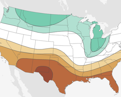
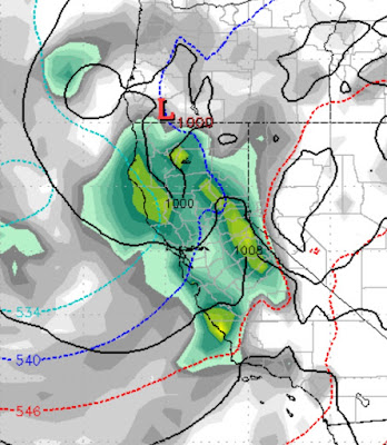
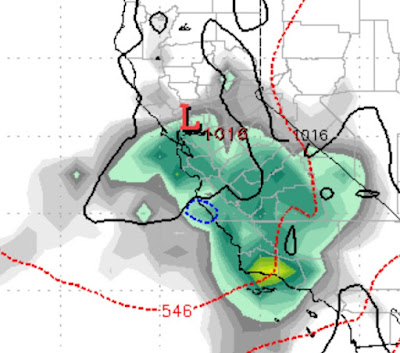
Before we predict what you will see in the 2020, 2021 winter season, let's get one thing clear; Mother Nature is in charge of this ship. We see some patterns that could repeat and we make our predictions based on those historical patterns. We are already beginning to see a pattern shift. In simple terms, we are moving into our wet season. That is good news because this was one of the driest summer/falls in recent memories. Below is a precip chart for this winter season provided by NOAA. The white represents average precip. We agree for the most part with this chart. Tahoe is right on the border of drier than average. Southern California will continue to see dry conditions and the drought mongers will have something to talk about after several years of above average precip. We are looking at Tahoe getting below normal precip. Possibly quite a bit below normal. Those averages have stayed consistent for many decades and quite simply we are due for another dry year. Couple that with La

Short Term Pattern Change to aid Fire Fighters

Image
 A low pressure system will drop out of the Gulf of Alaska and into the Pacific NW and and extreme Northern California. This system will produce cooler, more humid air along with some much needed precip: The timing remains around the 10th of October. Unfortunately, high pressure will move in on the heels of this system and dominate our weather for at least another week. We are seeing what could be a major pattern change starting around the 21st of October, especially for the Pacific NW as storms are growing in size as we move into the rainy season: The beauty of La Nina is that it can produce much stronger storms. We will need that to push out our blocking ridge. Stay Tuned ...

Will Ma Nature Help with the Fires? La Nina Winter

Image
 As our extremely dry pattern continues, there is some relief in sight, especially for Oregon, Washington and Northern California. We are tracking the season's first decent storm, which is prepared to come ashore around the 9th-11th of October. I know, that is a very long time from now, but this is the first sign that perhaps winter will start and fire season will wind up. Here is a look at the forecast from the 10th of October: With a ridge of high pressure to south blocking any sub-tropical moisture tap, we will not see copious amounts of precip. However, this storm is born in the north and will usher in much cooler and more humid air, which should give our heroic fire fighters a much better chance at containment. We do see 1-2 inches of liquid precip for areas of Northern California, Oregon and Washington. Cross your fingers that they are the right areas as heavy precip will be scattered. La Nina - It is a Certainty We will officially be in a La Nina winter this year. La Nina me

Western Fire Relief: None in Sight

Image
With fires blazing, we have looked a month into the weather future to find some potential relief. Unfortunately, this looks to be a very slow start to the fall/winter season for both the Sierra and Cascade Ranges. For Reno/Tahoe, the winds are going to shift from the west again, which will put us back in the smoke. However, the easterly flow that we have been enjoying this week, which blows the smoke into the Bay Area, will return from time to time. Eventually Ma Nature will crank up that storm machine and put out some of these massive fires. We generally do have several storms in the California Sierra in September and we are still in the first week. For the Cascade Range, they usually get going in September prior to the Sierra. We look for some storms to begin showing up and will keep a close eye on this. Here is the issue: We have a massive ridge of high pressure which is dominating the entire USA West Coast. Storms are going over or under the ridge. We expect that to move further so

Two More Days of Heat, then more Seasonal Temperatures

Image
What a crazy year it has been thus far. Really just goes to show who is in charge and it aint us! With record breaking heat overwhelming our area and much of the west, a cold front will drop out of the north and bring our temps back under control. Saturday will bring clouds and wind ... there is even a chance of some rain. here is a look at the forecast for 11:00 am on Saturday: Temps will not get out of the 60's on Saturday but will quickly recover to a very pleasant mid-70's through most of next week. I would be remiss not to compliment my good friend Sven over at Unofficial Rose . If you have been keeping up with his posts, they have been a terrific combination of back country conditions, ski area openings and current events. Imagine the casinos being safe enough to open, but not Mt. Whitney?? Huh? I guess the virus lives well at 15,000 feet with average wind speeds of 30 mph. Who'd have thunk that? Looking ahead to next winter; we are seeing pretty much neutr

Late Season Winter Storm Knocking on Door

Image
Under normal circumstances, we would be thrilled by a late season winter storm showing up this weekend. However, it seems the ski gods are rubbing things in our face. Of course they are not, and late season moisture is very beneficial for filling reservoirs and aquifers. However, doesn't it seem ironic that the last 2+ months of the ski season, we got very little precip. Since the ski areas closed, it has been snowing almost non-stop in the Sierra. Funny world we live in. This storm is already impacting the Western Sierra and will show up in our area late this afternoon with the peak of the storm not coming until Sunday afternoon: We expect about 12-15 hours of heavy snow for the Sierra. However, like all late season storms, this will not hold together as it crosses the Western Crest. We expect 4-5 feet of snow on the crest and about half that for the Carson Range, about 2 feet. It will be a colder storm with snow levels hovering right at about Lake Level or a little higher

Stormy Pattern to Continue, For the Next 15 Days ... At Least

Image
We oftentimes suggest remedies to combat dry winter spells. For example, we have put out a call for everybody to wash their cars, surely that will bring in stormy weather. I toyed with the idea of turning on my irrigation system a few weeks back, that would change the pattern. I think we have finally found the be all, end all, remedy; Close All the Ski Areas. Since the highly questionable decision was made by the lawyers (See Unofficial Rose) to close down all the ski areas because of our litigious happy society, we have done an about face in the weather pattern that is rarely seen, even here. Coincidence? Probably, but let's keep this in mind if we need a proven drought buster. We are tracking three more storms that are going to bring more snow and rain to the Sierra and state of California. These late season rains will oftentimes lead to a really nasty fire season, not to compound the many problems facing the state of California right now. The first storm is just off the