Posts

Snowmageddon For Upper Elevations of Sierra, Flooding for the Rest

Image
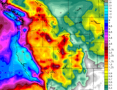
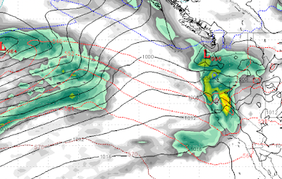
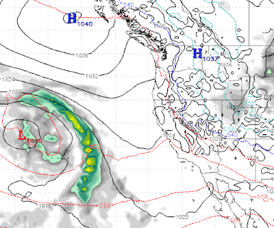
We have not seen precipitation forecasts like this one since 2017. We talked about that transition from La Nina to neutral and felt as though our weather could be effected back in October. Here is what is forecast for the next 2 weeks in the way of precipitation: Yes, many parts of the Western Sierra Crest are forecast to receive 25+ inches of liquid in the next 2 weeks. In the upper elevations, that translates into 20-30 feet of snow. The leeward valleys are looking at nearly 7 inches of rain in the next 2 weeks. While Mt. Rose should receive 10-12 feet of snow. These are mostly warm storms that will start out at very high elevations and come down as the the front passes and pulls in the cooler air. We believe this will be mostly snow for Mt. Rose, but other Tahoe resorts could be looking at major flooding. In addition, all that rain will melt snow and that water will go downhill which will definitely challenge the drainage systems around Reno, Carson City and other valley locations. 

Next Storm on tap for Wednesday

Image
  Another large, wet and warm storm is on tap starting Wednesday. This storm will be reenforced by smaller waves and will last, on and off, for nearly a week. The above graphic shows when the storm really gets cranking, Wednesday (1/4) evening. This storm will come in very warm, but snow levels will drop rapidly as a cold front comes through. Then, for the next several days, until the 9th of January, we will see all snow for all Tahoe resorts. However, by then most of the heavy moisture will have come through.  Mt. Rose will again have the best conditions with its high base as this storm will challenge the base of Rose and will probably deliver at least some rain. Although most of the precip will fall in the way of snow. Here is the forecast for January 10th: This is another storm with a subtropical moisture tap, or as the NWS likes to say, AR (Atmospheric River). However this storm will start out much cooler and will deliver all snow to Slide Mountain. Some Tahoe resorts, with low bas

Pattern to Remain Active Through Mid-January

Image
We are in a very active, wet weather pattern. All indications are that this pattern will remain active through at least the middle of January. We are on the cusp of a huge, wet and warm storm moving into the Tahoe Area. This storm has a sub-tropical moisture tap that is very powerful and is moving very warm and humid air into the Tahoe region and driving snow levels up to around 10,000 feet.  However, those levels will fall quickly to around 8,000 feet by Friday night (12/30). Eventually, they will drop down to around 6,500 feet. By then most of the moisture will have moved on. Here is a look at the forecast for Saturday afternoon: We are then looking at a much cooler but also a much weaker system for the 2nd of January: This system breaks up as it hits the Sierra. I expect at most just a few inches of snow for Mt. Rose. Then, another very warm and wet system moves into the Sierra on Wednesday the 4th: This system will stick around and be reenergized through the 8th of January. I bel

Massive Pattern Change Will Bring Heavy Rain to Valleys and Deep Snow to Upper Elevations

Image
Merry Christmas to all! I hope you are having a wonderful holiday season.  If you caught our last post, we have a huge pattern change and it is knocking on the door. Before we get to the timing and snow levels I thought it prudent to show the precip forecast for the next 10 days: We are looking at 12-16 inches of liquid for all the mountains around Lake Tahoe. Just South of the lake, they are going to get buried in the upper elevations. Add this to our already healthy snowpack and you see why averages do matter! Meanwhile, many valley locations will see 5+ inches of rain over the next 10 days. Storm 1 (Tuesday 12/27 @ 4am) This storm is packing a subtropical moisture tap and will be the warmest of the storms with snow levels starting out at 10,000 and dropping through the event. The event will last 20-24 hours and by the end, it will be all snow down to 7,000 feet.  Storm 2 (Thursday 12/29 @ 6am) The next event in the series is actually two storms. This will be another warm event and w

Not a Carbon Copy of Last Year

Image
I have been hearing about all the December snow and am continually reminded that the spigot shutoff for a few months after December, last year. That is not happening this year. First, we have a couple of near misses that will produce some precipitation for the Sierra starting Friday and lasting through the weekend. I do not expect any major storm from this system for Tahoe. The same cannot be said for the Pacific NW as they will get a blast from this one.  Then, next Tuesday (12/27) our pattern changes. A very warm storm will pick up a weak sub-tropical moisture tap and bring rain and snow to the Sierra. Folks, this one could rain to very high elevations (9,000 feet) as the air is very warm. You have to go up to BC to find some colder air. Then, late on Wednesday the 28th of December another system drops in from the north. This will still be a very warm system, but nothing like the previous storm and hopefully will bring all snow to Slide Mountain, although very wet, heavy snow. A thir

Tahoe Will be Dry Through Christmas

Image
After nearly 10 feet of snow at Mt. Rose in the last 10 days, things are going to dry out as a ridge of high pressure will set up just off the Pacific NW and block anything trying to get into us. There is a slight chance of a storm making it through around the 22nd or 23rd, however right now that storm looks to be heading north of Tahoe. Here is the precip forecast for the next 15 days: This may not be a bad thing for the resorts. If anybody remembers what Mt. Rose Highway looked like last Christmas with many of our western neighbors deciding they could drive that road in a blizzard and DOT having to shut it down just to get our friends out of the ditches. This should be a boom to the economy of the entire area.  The storms will return, trust me. Ma Nature has a way of deciding when, so nothing is carved in stone. Stay Tuned...

Weather Pattern to Remain Very Active

Image
  We are tracking a major storm which will start on Thursday (12/8) and last through the weekend. This storm also has a significant moisture tap especially this weekend. The above forecast is for 10am on Saturday (12/10) morning.  The potential of this storm is greater than what we saw last week, where nearly 4 feet of snow fell on Slide Mountain. Here is the precipitation forecast for for the next week: We are looking at another 3-6 feet for Slide Mountain.  Stay Tuned ...