Posts

Slider For Thursday; When Will We See Heavy Snow?

Image
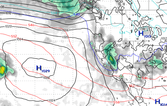
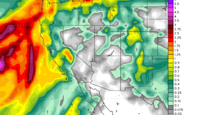
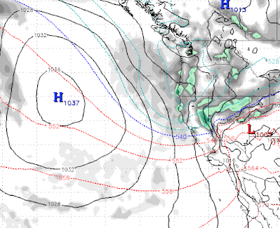
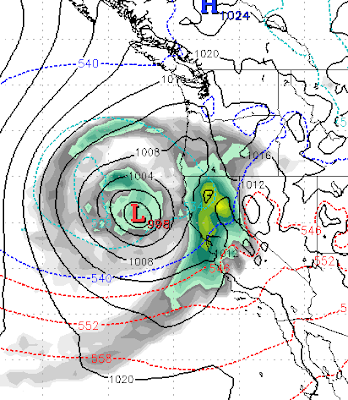
We have another reenforcing shot of cold air and what looks like a pretty decent slider type system for Thursday (11/30). Sliders come out of the north and have a much greater effect on the Eastern Sierra. Here is a look at the forecast for very late on Thursday as this storm moves in: We are looking at all snow for all Tahoe resorts with accumulations of around 6-12 inches. We can expect this pattern for the next couple of weeks as the models have several smaller systems which are capable of 6-12 inches moving in.  This weekend we will get a warm up with temperatures much warmer ahead of the next system which is slated for the 7th of December. When will it start to snow big time? We have been studying the long range forecasts and this pattern may persist through December. However, if you believe any of this, we could see a major pattern change as we ring in 2024. Of course that is pure speculation by the models, but that is all we have to go on for now. Stay tuned ...

Storm Shifts North; 6-12 Inches by Sunday Afternoon for Carson Range; More West of Lake

Image
 This storm which has stubbornly stayed off the coast while sending precip to Southern California, has shifted north, grabbed a little cold air and will form right over Lake Tahoe. This is not the event we were hoping for 10 days ago, but Mt. Rose could see a foot of snow which will greatly help them to open additional terrain. After this storm, however, it looks like an extended dry period. Here is the forecast for 6:00 this afternoon (Saturday 11/18): There will be a shadowing effect, so the crest above 7,500 feet on the west side of Lake Tahoe will pick up 1-2 feet. Here is the precip forecast, again, about 6-12 inches for Mt. Rose. This being a very warm storm will produce quite a bit of rain below 7,000 feet. The precip forecast for the 2 weeks following this event is nada, let's hope that changes. Stay Tuned ...

Storm Splits, Dies at Sea

Image
I am not going to waste a lot of your time here, the storm which we forecast split and will mostly die before making it anywhere near the Tahoe area. In addition, the weather models, which whiffed on this first storm of the season are predicting very dry weather for at least the next couple of weeks. Here is the forecasted total precip in liquid over the next two weeks: Looks like a slow start to the season ... Mt. Rose made a bunch of snow and is open top to bottom if you want to get some turns in. Stay Tuned ...

Storm Machine to Crank Up Next Week; Winter Outlook

Image
Storm Watch Today's storm is nothing but a small teaser for what looks to be a major winter storm in about 8-9 days. We are tracking a major storm that both the EC and GFS weather models are in very good agreement. Here is a look at the forecast for the 15th of November: If this storm holds together it will begin somewhere late on the 13th and could bring copious amounts of precip to the Sierra and Carson Ranges of Lake Tahoe. We believe this will be all snow for Mt. Rose as snow levels will start high but quickly come down. The following is the forecasted precip for the next 10 days. Needless to say, if this hits as all snow, Mt. Rose should be able to open quite a bit of terrain as we are talking about upwards of 4 feet. Let's hope it does hold together as we are seeing a ridge in the jet over our area moving forward, not unexpected this time of year. Season Watch We have been very lucky the last several years with our season snowfall predictions. We were the only site that p

One More Cold Front, Then Big Warm Up

Image
I hope you are enjoying the pleasant morning and early afternoon. But change is a coming! A strong cold front will push down the eastern Sierra in a slider like system. These systems are very hard to predict when it comes to precipitation, but we are thinking less than 6 inches for the Carson Range. Here is the forecast for late to tomorrow night: Notice the very cold air has already pushed through. That will drop our temperatures by 20-30 degrees, at least and plunge us back into the 20-30 degree below average range. The good news: high pressure is going to take over and our temps will quickly recover. We could even see some above average temperatures by next weekend. Here is the forecast for late Friday night (4/7): Notice the warm air stretches all the way up into BC! This should mean some stellar spring skiing conditions for Mt. Rose, probably starting next Thursday. This warm air should stick around until at least the middle of April! Stay Tuned ...

What Kind of Winter Has This Been?

Image
This winter has been one for the ages. Ironically, this is the 2nd snowiest winter for the Sierra behind the winter of 1958. It has also been much colder than average, which means the snowpack is sticking around much later than usual. As my friend Sven mentioned in his last post  , Mammoth has announced they will be open through July! Here are some charts that really illustrate the type of winter we have had. Remember, most California reservoirs are now completely full! Do not look for a quick warmup, here is the temp outlook for the next couple of weeks, which is almost laughable ... almost:  Here is the % of average precip for this winter: How snowy has it been in the Sierra? In addition, we received nearly 8 inches of snow last night in South Reno. Here is the model run for predicted precipitation last night and early this morning: Everybody got fooled by this one, including us! Mother Nature is just toying with us, obviously! Stay Tuned ...

Weather to Remain Cool and Stormy For Next Couple of Weeks (At Least)

Image
Winters tight grip on the Tahoe area will continue into the foreseeable future. We have a series of storms and reenforcing cold fronts that are stacked up and waiting to continue the onslaught on the Sierra and Tahoe especially. Tuesday 3/28 This is a cooler storm, will likely produce snow above 6,000 feet but those levels could drop as well. For now looks like rain for the valley. This storm will send waves at us following the main front for a few days. Monday 4/3 Very cold air dips way down into Central California. Wednesday (4/5) If this holds together, it will usher in a very stormy pattern. Saturday 4/8 Could this be a late season AR event? It is two weeks out, so no guarantee, but anything is possible this year! Finally, here is the precip forecast for the next couple of weeks. Amazingly, the Central Sierra around Mammoth is looking at another 10-12 feet of snow. The western crest should see 6-8 feet while the Carson range is in the 3-5 foot range. Stay Tuned ...