Posts

Storm Train to Continue; Season's First Big Storm This Weekend Into Next Week

Image
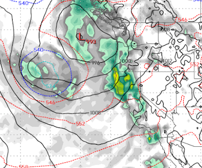
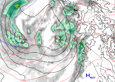
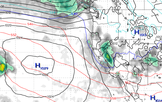
Another fast moving, reasonably warm storm is knocking on the door. This storm will move through the area very rapidly and probably leave around 2-4 inches of very wet snow in the Carson Range and Mt. Rose in particular. Here is for forecast for tonight (1/16) around 11:00: This storm will be out of the area by early tomorrow morning but should leave some snow down to about 5,000 feet on the backside. Because the leeward valleys currently are experiencing a very deep inversion, there is a possibility of some freezing rain, which is a very rare occurrence in these parts. Take a look at this setup for the coming series of storms starting very late on Friday (1/19): This is a typical El Nino setup, with several smaller storms that will move inland one after the other. The big stuff is forecast to come in starting Sunday (1/21) afternoon and will hit the entire state of California. So we are looking for snow, on and off, starting Friday and lasting through the following Tuesday. The one do

Next Storm Up For Saturday, Then Warming Trend

Image
Our next storm will come in much warmer than this past storm. It could even help DMV get the roads somewhat passible in the valleys. This storm will tap into tropical moisture, but the snow to water ratios will be much lower. Put another way, we will get more moisture but either the same or less snow in the mountains. Here is the forecast for 4:00pm on Saturday (1/13): As this storm begins to hit our area, we could see some valley snow due to the Ice Box Effect. Currently, the snow cover and surrounding mountains are holding the cold air in the valley. However, as the storm begins to come through, the warmer air will mix and we believe it will bring rain and a very soupy mess. As far as the Carson Range, we are looking for 1-2 feet of snow. Again, this is a fast moving storm and will be clear of our area by early Sunday morning. Much needed relief will follow next week as we will see valley high temps well into the 50's. El Nino will continue, however, next weekend with what is sha

Storm Machine is Beginning to Crank Up

Image
These recent storms are certainly not indicative of what we would consider El Nino storms. However, after a very dry start to winter we will take it. We have been talking about the possibility of the storm machine finally showing up and we are seeing signs of that. First, we have another very cold slider type system, dropping out of the north for late Tuesday into Wednesday. Precip amounts for these types of storms are very tough to predict. Here is a look at the forecast for Wednesday: This will be all snow all the way down to the valley floors. We will probably squeeze out 6 inches and a dusting in the valleys. We are tracking a much larger storm for Saturday (1/13). The models are in good agreement about this event. This storm has the 2 elements we like to see; cold air from the north, warm and moist air from the south. What it is lacking is a blocking force to the East which would allow the storm to stall and dump. We don't want to get too far ahead of ourselves, but we are see

Cooler Storms On Tap

Image
We have another series of more promising storms slated to hit our area on the 3rd, 6th and 10th of January. All of these storms are much cooler and will bring all snow to all Tahoe Resorts and snow to some valley locations and lake shore locations.  Unfortunately, these are still not the storms we are looking for as they will enter and exit our area in a relatively short period of time as these are all fast moving storms. 1/3/2024 This storm looks to be the best of the bunch. It will begin to effect our area on the 2nd (Tomorrow) but the heavy stuff looks to be coming early on the 3rd. All the weather models are in good agreement. We see around a foot of snow for Mt. Rose and possibly slightly more. Again, this is a much cooler storm. 1/6/2024 The models are not in total agreement on this one. The above image is the forecast by the ECMWF model, which has been the most reliable of the bunch. This will again be a colder storm and will begin to effect the area in the late afternoon of the

As the Warm Storms Approach, Keep an eye on the Week Between Christmas and New Years

Image
We have a series of very warm storms approaching the Tahoe area. We talked about this in our last post. These storms and the associated precip are born in the South and West and are not working with much cold air. That will do two things: limit the power of the storms and bring mostly rain below 8,000 feet starting later today (Sunday 12/17). Mt. Rose is usually the big winner in the El Nino years. Of course the exception is that these storms oftentimes are not powerful enough to stay completely in tact when crossing the Western Sierra Crest. So the Carson Range and Mt. Rose in particular can get shadowed out. That is what is going to happen this coming week. Notice the precipitation is staying mostly to the west of Lake Tahoe. Some will make it over, but the higher elevations on the western side of the lake will pick up more precipitation. Much of this is due to a week storm that really has no cold air to work with as it moves on shore. It will actually move up and down the coast befo

Major Pattern Change (Finally) Set For Next Week

Image
We predicted above average snowfall for the year. I am sure that most readers are thinking we are crazy. This has been a slow start to say the least. That is about to change, at least precipitation wise. A series of warmer storms will pull moisture from the tropics and deposit it all over California and Northern Nevada. The fun gets started a week from today. Remember these are very warm storms and snow levels will most likely be above Lake Tahoe (6,400) feet. Monday December 18th: Friday December 22nd Christmas Day A couple of things with noting here: These storms are progressively turning colder. This is a storm train where the storms are also getting stronger. We are looking through Christmas Day, but this pattern is showing no signs of changing. These storms are typical of El Nino, in that they are warmer and not quite as strong as the storms we were seeing last year. They are also more frequent which can lead to heavy precipitation with very little letup, sometimes for weeks. Fina

Slider For Thursday; When Will We See Heavy Snow?

Image
We have another reenforcing shot of cold air and what looks like a pretty decent slider type system for Thursday (11/30). Sliders come out of the north and have a much greater effect on the Eastern Sierra. Here is a look at the forecast for very late on Thursday as this storm moves in: We are looking at all snow for all Tahoe resorts with accumulations of around 6-12 inches. We can expect this pattern for the next couple of weeks as the models have several smaller systems which are capable of 6-12 inches moving in.  This weekend we will get a warm up with temperatures much warmer ahead of the next system which is slated for the 7th of December. When will it start to snow big time? We have been studying the long range forecasts and this pattern may persist through December. However, if you believe any of this, we could see a major pattern change as we ring in 2024. Of course that is pure speculation by the models, but that is all we have to go on for now. Stay tuned ...