As the Warm Storms Approach, Keep an eye on the Week Between Christmas and New Years
We have a series of very warm storms approaching the Tahoe area. We talked about this in our last post. These storms and the associated precip are born in the South and West and are not working with much cold air. That will do two things: limit the power of the storms and bring mostly rain below 8,000 feet starting later today (Sunday 12/17).
Mt. Rose is usually the big winner in the El Nino years. Of course the exception is that these storms oftentimes are not powerful enough to stay completely in tact when crossing the Western Sierra Crest. So the Carson Range and Mt. Rose in particular can get shadowed out. That is what is going to happen this coming week.
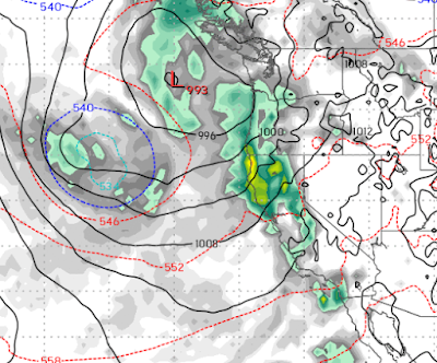
Notice the precipitation is staying mostly to the west of Lake Tahoe. Some will make it over, but the higher elevations on the western side of the lake will pick up more precipitation. Much of this is due to a week storm that really has no cold air to work with as it moves on shore. It will actually move up and down the coast before finally coming inland in Southern California.
We will take what we can get and it should be all snow for Mt. Rose, 6-12 inches through next week.
However, the week after Christmas is shaping up to be much more interesting. The perfect combination of huge storms for all of the Lake Tahoe area, bring a large and powerful storm from the north that taps into sub-tropical moisture from the south.

That is what we are seeing and our best guess is that significant precip will finally come to the Sierra around the 27th of December and last through at least the New Years.
This has been a very tricky year, but our confidence is pretty high for this event. We will continue to follow this and report accordingly.
Stay Tuned ...