Posts

Suggestions For Changing The Weather Pattern

We like to have fun here at the TWB. If you are looking for hard core scientific data, perhaps you should read no further. I just wanted to let all my faithful readers know that I am doing what I can. In the last 2 days I have done the following: Washed Car, Inside and Out Cleaned Gravel and Salt of Garage Swept Driveway Removed Ski Rack from Car Number 4 could be the clincher! The above list usually brings in some inclement weather. I believe if we all put our collective positive energy together, we can change the pattern ourselves! I did look at both GFS and EC models and they are in agreement for a quick moving weather event on Sunday that could bring up to a foot of snow to the Sierra.
When it Changes it will Really Change. For Now, Looks Like the Status Quo

Image
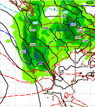
I just looked at the latest EC run. Unfortunately, the smaller storms for this week appear to have fallen apart. Our blocking ridge is moving south, but also east. That means it will continue to block any storms from coming into our area ... yucksville! There is a glimmer of hope for late Saturday into Sunday for some reasonable precip as the biggest of the systems will shove that ridge south and west, perhaps allowing for a short storm window. EC is still forecasting the following for Sunday morning: Unfortunately, immediately after this storm our blocking ridge appears to be moving well north and east. Remember this; There are no normal weather events. Forecasters rarely use the word normal, when they do it is a mistake. Especially for our area. There are only averages. 3 years ago we were inundated with record breaking snow. Parts of Squaw Valley had a season total of nearly 1,000 inches of the white stuff. The law of averages has caught up with us these past two years. Ho

Enjoy This Weather, It Will Change Early Next Week

Image
A series of small systems could come through our area starting next Tuesday. The stormy weather could last through the following weekend with each system getting progressively larger culminating on the 11th with a major precip event. Again I say "could" because, as you know, weather forecasting has been challenging to say the least these past few months. Here is a look at the forecast larger storm for the weekend of the 11th: My confidence of a major change is due to mounting evidence from a number of fronts. We first talked about the PNA and AO both going negative simultaneously. That should allow some of that Arctic air to slip into our weather pattern instead of the eastern 2/3 of the USA. The biggest change is the shifting of the blocking ridge of high pressure to a more traditional position. This should allow a storm corridor to form: Here is a forecast look for this weekend: As you can see, the blocking ridge of high pressure is in a terrible position. It