A Series of Storms Poised to Hit Tahoe Through Mid-December
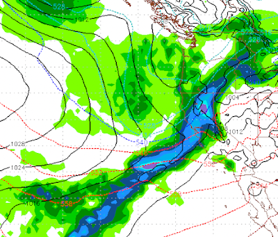
This graphic shows you the forecast for mid-morning tomorrow. It is a beautiful depiction of what is known as the Pineapple Express. That is a moisture tail that stretches from Lake Tahoe all the way down to the Hawaiian Islands. These sorts of events pull very moist, warm air from the tropics into the Sierra. They usually bring very heavy rain to the California coast and very deep snow to the Sierra.
We have two storms, one south and one north that will merge together to form one very large storm, currently here is what things look like:
The fun does not stop there. Late Saturday, another storm system forms with another tropical moisture tap that will bring additional heavy snow to the Sierra:
This storm will bring near continuous snow from Saturday evening through Monday.
As if that is not enough, we have another large storm poised to hit the Sierra next Friday (12/9):
With our ridge of high pressure shoved way out to sea, the storm door should remain open through at least the middle of December.
Here is a look at the precip total forecast for the next 10 days:
These storms should bring all snow to Mt. Rose.
Stay Tuned ...


