Posts

Squeeze Play Coming

Image
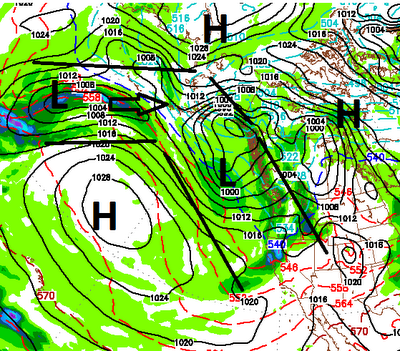
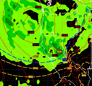
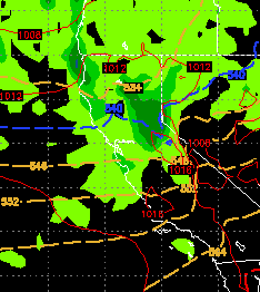
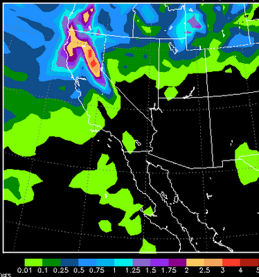
Short term things are looking pretty good. This storm should dump about 6-12 inches of fresh snow on Slide Mountain. My friends over at Unofficial Mt. Rose have reported that the snow guns are working over time and with the cold weather, they should be very productive. Things are getting close at Mt. Rose. We have another weaker storm coming in for next Thursday and Friday. This storm is actually going to travel down the coast, go right past us and then make an abrupt 180 degree turn, come back north and head toward our area. Or so the models are forecasting. We should get something out of that storm. Long term, things look really good ... read on. Ok, I have to admit that I made this one up but I kind of like it, so I will stick with it. First let me define the squeeze play. High Pressure over Hudson Bay blocks storms and sends them down the west coast. Meanwhile High pressure moves west into the Pacific ocean. This creates an alley for storms to move down the west coast, squeezing

Storm Hits Tomorrow, Thanksgiving Storm on Horizon

Image
What a beautiful run of weather we have had for what seems like forever. With the exception of just a few days, the weather has been pretty nice since the beginning of April. However, who wants nice weather. You can't ski on rocks. I think I speak for many people when I say, "Bring on the crummy weather"! Well, if you believe the EC model, that crummy weather is knocking on the door. If you have not shut down your irrigation system (sprinklers) go out and do it now. That is because it is going to get really cold. Saturday night the low temps will be down around zero in the Sierra (or colder) and low teens in the valley. This change is due to a decent storm that will usher in cold air and some moisture. We have been talking about this for a couple of weeks now. Here is my best guess for this weather event: 1-2 feet of snow along the Sierra Crest North and West of Lake Tahoe with lesser amounts in the Carson Range (6-12 inches at slide). This is not going to be the

Major Changes Headed Our Way

Image
Our weather is going to stay nice through most of next Wednesday with high's in the 60's and perhaps even a 70 or two. However that is all going to change come Thursday 11/8. Our ridge of high pressure which is keeping our weather very mild is going to get shoved south and west and that will open a corridor for a series of storms. We should enter a stormy period that should bring decent precipitation our way through the end of the month. First things first, here is a look at the EC Forecast for late Thursday: It looks like a decent wave of precip will be here for Thursday/Friday and then another shot of decent precip on Saturday. This storm will usher in cold air and we should see all snow on Slide Mountain. How much snow? Here is a look at the EC precip total forecast: For some reason, EC usually forecasts low end precip. I would not be at all surprised if we see double these amounts. I look for 2-4 inches at the crest west of Lake Tahoe through next weekend and s

Weather Pattern Changes Coming Slowly

Image
Current We have an impressive front approaching the Pacific NW coast. Unfortunately we have a strong ridge of high pressure that is very dry. These two air masses are going to collide. The result will be the ridge will be weakened as will the front. That means a severely weakened storm will come into our area Thursday and Thursday night. The storm will produce light rain and snow for the mountains with little if any precipitation for the valleys on Thursday and Thursday night. Right now Halloween does not look bad for the trick or treat'ers. Mid-Term Looking ahead, the ridge will build back in and by the weekend through early next week our temps could be 10 degrees above normal so prepare for another shot of Indian Summer.  Toward the end of next week, a much more impressive storm is headed our way. The models are all advertising this storm with slight differences with strength and timing. The European model, which has been by far the most accurate for almost a year now,

Storm Continues to Dump

Image
Current 3 feet of snow has fallen in some areas of the Sierra with what appears to be another major snow event poised to hit this evening. The following shows the EC Model for tonight: When all is said and done, many mountain areas around Lake Tahoe will pick up 4-6 feet of snow. That should provide a very nice start to the winter. The good news is that this storm was not an anomaly such as a typhoon crossing from Japan. This storm dropped out of the Gulf of AK and picked up ample moisture from the Pacific Ocean and dumped. That is a good sign for the storm machine to start cranking up. El Nino Watch El Nino has weakened and the ENSO outlook is for neutral to weak conditions. About 1/2 the models are saying we will move into a weak to moderate El Nino for the winter of 2012/2013, while the other half are saying we will remain in a neutral ENSO. Summer is Over Summer appears to be over. 80's and 70's will not be seen again around here for some time as the long range

Strong Storm Targets Tahoe

Image
First of all let me apologize for my absence. I had a death in the family and have been out of town for nearly 10 days. However, had you read my post from the 3rd of October you were warned that a storm was very likely to make it down the coast and hit our area hard ( Post From October 3 rd) starting today. I must say, getting it right from that far out is the exception rather than the rule especially since I was the only fool talking about it 19 days ago. This storm is packing a very good precipitation punch and areas north and west of Tahoe will pick up in excess of 2 feet of snow at the crest and up to a foot of snow at Lake Level, especially on the north shore. Snow levels are plummeting and snow is falling as low as 5,000 feet which means travel on I-80 is going to be a mess. Here is the precipitation forecast through Thursday, remember this is liquid precipitation: As you can see, some areas north and west of Tahoe could pickup 3-5 inches of liquid precip. That means iso

NOAA Issues El Nino Watch; No Storms in the Near Term

Image
We have been discussing El Nino since July. However, at that time we moved into a weak El Nino and it has weakened slightly since. However, NOAA is still predicting a moderate El Nino through the winter which bodes well for snow in Tahoe. We have had unseasonably warm and quite frankly beautiful weather through the entire month of September. That is going to change starting tomorrow and  you will feel those changes through the weekend. We have a large blocking ridge of high pressure that is keeping what few storms there are, well to our north. This storm is the exception and a piece of energy should break off and give us some very light precip. Perhaps a dusting of snow above 10,000 feet on Saturday night. Remember, about this time last year we had a typhoon cross the pacific and slam the Sierra with rain and high elevation snow. Of course it did not snow again until mid-January. I do not see that happening at all this year. There are indications that around the 18th of this month,