Posts

Warm, Sloppy Storm Arrives Early Tomorrow Morning

Image
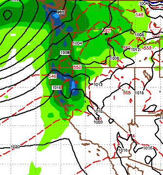
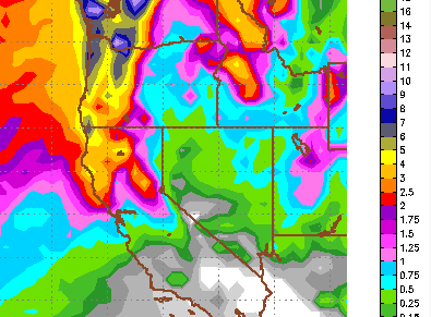
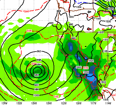
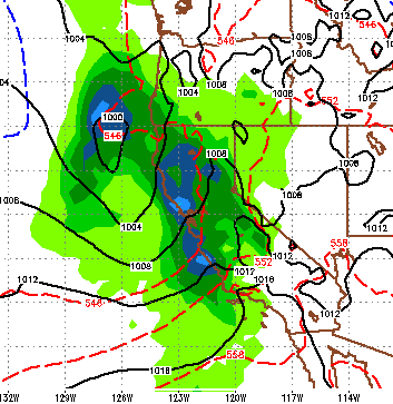
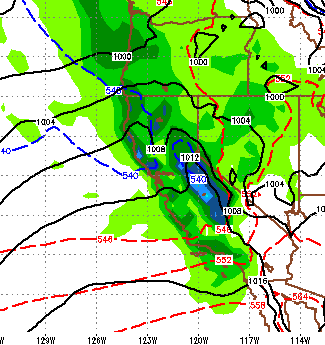
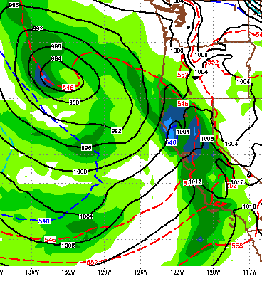
We have been talking about this storm for over a week now. The timing has not changed as this storm will drop into our ares from the north and west. It will tap into the very warm and moist air out int he Pacific and bring some rain to the Sierra below 9,000 feet to start with. As the front moves through those snow levels will drop to around 7,500 feet. This storm is fast moving and should drop around a foot of snow around the upper elevations of the Sierra Crest west of Lake Tahoe. About half that in the Carson Range (as usual). Here is a look at the forecast, notice the approaching storm, this should be late tonight: Snow should last through the morning tomorrow and the afternoon ... however at elevation, which is going to be very high for this storm. Most resorts over on the west side, that are challenged for elevation will receive all rain. We have also been talking about another storm in the series for Sunday and Monday. Here is a look at very late on Sunday night: The

Active Weather Pattern Continues

Image
As our active weather pattern continues, we have a decent shot for snow tonight & tomorrow, Wednesday and Thursday and then the following Sunday and Monday. Our best chance for a good storm and thus a powder day is very late Wednesday into Thursday, with snow most of the day, which means Friday would be the day. Prior to that it is going to warm up ahead of the storm. Snow levels will be around 6,500-7,000 for tonight/tomorrow and around 7,500 feet for the Wednesday/Thursday storm. Here is a look at precip estimates for the week: As usual, north and west of the lake is the big winner looking at 2-4 inches of liquid precip possible with around an inch for the Carson Range. Of course all of this can change ... there is a ton of moisture to tap into. If the dynamics of these storms change even slightly, we could be talking about significantly more precip. Last post we talked a little bit about two weather dynamics that will make for an active Spring; and El Nino has develope

Are Weather Patterns for our Area Really Changing?

Image
I will address what appears to be a long term and possibly violent change in our weather pattern. First here is a storm update. The first wave has pushed through and brought with it some cold air. The most snow fell in the Central Sierra where Mammoth picked up nearly 2 feet. 6-12 inches fell on Rose. The next wave is coming in tomorrow around 4:00pm. It will again have a bigger impact south of here, especially Southern California. Here is a look at 4:00 tomorrow: We are going to get a decent amount of snowfall up here, but much of the moisture will fall south of here, where they really need it! These two storms have been a real blessing for the state. I call it free water for all, but the miracle of desalinating the trillions of trillions of gallons of water and dumping it on California is drought stricken areas is fantastic news and supports the law of averages, they were really due. The storm that I am keeping an eye on has Tahoe in its cross hairs for next Thursday. This

7-10 Days of Storms Begin Thursday

Image
Our pattern has completely changed because of a number of factors. Storms are now moving across the Pacific, raining on Hawaii and coming our way. The Westerlies have finally returned. What does that mean? Rain for all of California. Potentially lots of it! Mammoth Mountain is in for a very stormy 10 day period starting Thursday. So is Tahoe. In fact, when all is said and done, Tahoe looks to be back in the bulls eye. Although some very beneficial precip should fall on all of California. Starting very early on Thursday, the first wave moves in: Then Friday evening the next wave moves in, notice the storm just off the coast: Another wave should affect Northern California, including Tahoe next Monday as the stormy pattern continue until late next week. Finally, as we expected the total liquid precip numbers have gone up for the event: The western crest around Tahoe is looking at 7-8 inches of liquid precip. A big part of California is in the 4-5 inch range. The Car

March Coming in Like a Lion

Image
We will have a general warming trend through about the middle of next week. Look for dry weather with highs around 60. Then things change. We have been talking about the possibility of a pattern change coming at the end of February for the last week now. As we approach that date, the models are in surprising agreement that we could be in for a major and very beneficial pattern change. We also talked about our friends in the Central and Southern Sierra joining in on the fun. It has been dry down there for over a year. Well it looks like our wish may come true. There are a series of storms making a beeline right for Central California, right in the heart of farm country, where they need it most. Remember, this is still a week out, but when the models are seeing this and a number of other factors are suggesting (Late Phase strengthening MJO) this, my confidence is reasonably high. Here is a look at the first wave, set for the February 27th: Heavy moisture this time with the

Storm For Wednesday Fizzles Out, High Pressure Take Control for Next Week

Image
The storm I was trying to will into our area appears to have fizzled out and will not make it down with any favorable precipitation. That is unfortunate, as the high pressure ridge to our west will move north for at least a week and block anything from coming into our area. It will get windy on Tuesday and a cold front will pass through the area. However, that will only drop temperatures to average for this time of year. However, those temps will quickly move to above average and stay that way for the next 7-10 days. In my last post I hinted that more significant change may be coming for March. It is very difficult to forecast weather more than a few days out. However, checking a number of weather models, a chance exists for a significant change to our current weather pattern. Right now, that change looks to be starting in about 10 days. The EC model, which is the most reliable, has a significant storm affecting the entire state of California. Hopefully this holds true, as the centra

Two Storms, Then High Pressure Takes Control

Image
The wind that we have experienced the last few days is a storm to the north that will eventually push some moisture down toward Tahoe. At this point it is not looking like much. We have two storms coming and both are at the very southern tip of precip. First here is a look at late Saturday night: We are on the warm side of this storm and snow levels again will be very high. Most of the precip will be confined to west of Lake Tahoe. The Carson range may pick up a few inches (6 inches if we are lucky) and as much as a foot for the Western Crest of the Sierra. Late on Tuesday a second storm comes in. That storm will be similar to this storm, but could provide more precip further east. With it will come a cold front that will push temps about 15-20 degrees cooler. Our 60's and 70's will be 40's and 50's after Wednesday. Here is a look at late at Tuesday night: These storms are pretty disappointing. I was hoping to build on the momentum of last weekends super st