Posts

Think Winter is Over? Think Again; Next Storm Cycle Starts Early Wednesday

Image
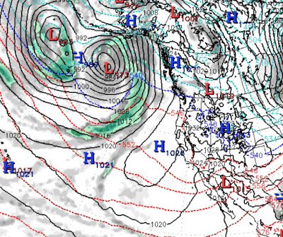
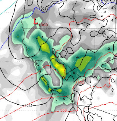
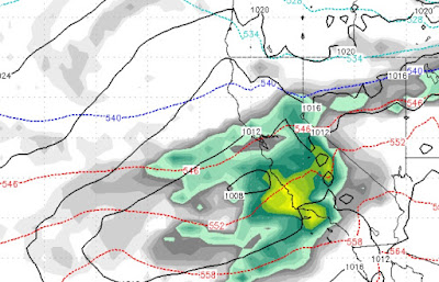
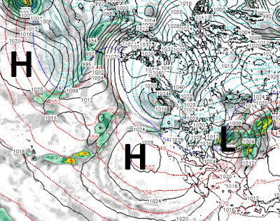
Who knew the sky is actually blue? I certainly had forgotten that. We all had a very nice reminder and will continue to be reminded for a couple of more days; then the next storm cycle starts and this looks to be another good one. We will start with Wednesday (3/20): This is a weaker, warmer system, but the backside of this system will bring in some cold air. It will clear out early on Thursday. Then, late on Friday or early Saturday (3/23) the next storm comes in. It is packing more moisture and will be much colder: That storm will hang around through mid-day Sunday, then after another short break, another storm comes in from the south and west: We are trying not to get too far ahead of ourselves, and these storms are much weaker than what we have seen, but in the week starting next Wednesday, we are expecting about 2-3 additional feet up at Mt. Rose and probably more around the Western Crest and down in Mammoth. Stay Tuned ...

Blocking Ridge Going to Keep Us High and Dry for the Next 8-10 Days

Image
A ridge of high pressure is dominating our weather and will continue to do so for at least the next 8-10 days. Right now that ridge is a little too far off the coast, allowing weak systems to drop in from the north, but that ridge is going to edge closer to the coast and block everything trying to make it's way to our area. When the ridge does finally setup, I expect temperatures to actually creep above average, possibly as soon as this weekend. For now, these weak systems coming down from the north will keep us below average. Those temps will inch up until we finally see some sign of spring. Stay Tuned ...

Last Storm in Cycle, Knocking at the Door

Image
If you have read our last few posts, you know that another pretty good sized storm is headed our way that will effect the entire state of California for the next 3 days. We believe this will be the last storm in this most recent cycle. Of course, the storms have come so close together that it has been difficult to define a storm cycle. Also, because of the recent storm history and the fact there is still plenty of weather out there, our confidence is not exactly high that we may be entering a dry period, but for now that is what the models are saying. The peak of this storm should be about mid-morning tomorrow: We are staying with our earlier prediction that snow levels should average around 6,500 - 7,000 feet, which means a likely mixed bag at lake level and all rain for the leeward valleys. These storm will spill over and we expect decent amounts of rain for the valleys. Here is a look at the storm total, not what we have been seeing, but storms do weaken the later we ge

60 Feet in 60 Days; Not Possible? Think Again

Image
Imagine: No Blower Trucks, No 4 Wheel Drive and No Weather Forecasting computer models. In 1846, we hit a similar weather pattern where it literally snowed for 2 straight months, starting in late October! The rest is history and we now have Donner pass and Donner lake to commemorate the 39 lost souls in the Sierra who attempted to cross the pass and were caught by an early and unforgiving winter. Folks, this is the snow belt and we should not be surprised by anything Ma Nature throws our way. What is a bit surprising is our record breaking winter, just 2 years ago, looks like it may fall by the wayside. I say that because we are tracking 3 more major winter storms in the next 10 days that will continue to dump copious amounts of snow on the Sierra. Remember, we had a very slow start to the season and we even heard complaints about our above average snowfall prediction. To which we replied, "Just Wait". Now 2 months later there are areas of the Sierra that will have picked

Change in Forecast: It is Going to Snow Forever!

Image
If you read our last post, the first storm that we thought would miss us and not get over the Sierra has been given a powerful shot of energy. Couple that with a moisture tap to the sub-tropics and we have all the makings for another major winter storm. We should not be surprised. 2019 has been this way and looks to continue being this way. So the next storm cycle starts ... now! The leading edge is creating violent down slope winds for the leeward valleys and especially the foot hills with 100+mph gusts being recorded and wreaking havoc up and down the range. Behind it: Notice the moisture tail that extends to the end of the earth! This is the forecast for today (2/25) at 4:00 pm. This is only gets better (or worse, depending on your perspective). This should continue through Thursday with some of the heaviest precip we have seen this year. On it's heels, the storm we talked about last post, here is a look at the forecast for noon on Saturday: But this just ke

Next Storm Cycle is not Far Off

Image
Not much has changed since our last post. This last storm was another overachiever. That storm has moved on and high pressure is going to setup along the cost. Our temperatures will gradually warm. Here is a look at the current weather: You can clearly see the ridge of high pressure that will dominate our weather. We could see a very weak slider this weekend, but by next week we will be back close to average temps. However, like everything else since we turned 2019, that is going to change when the next storm cycle comes in. We will start to feel the change around the 26th. Our ridge of high pressure is going to get bumped well south and that should open the storm door once again. Here is a look at the forecast for the 26th, notice the difference between the map above and the map below: You can notice the storms are beginning to stack up. Then around March 2nd, the next cycle of storms begins with the arrival of the first storm: Notice the distinct storm track around

El Nino is Underrated; 12 Days Until Next Storm Cycle

40 feet in 40 days. That is very close to what much of the Sierra has picked up in the last 6 weeks. Now, we can catch our breath for the next 10-12 days before the next storm cycle shows up. The next will be warmer with potential sub-tropical moisture, not unlike what we saw last week. Between now and then, we expect cooler than average temperatures. However, we will be moving closer to average by next weekend. Between now and then, we have a small slider that will drop down and reinforce our cold air. We do not expect much precipitation out of this one. Stay Tuned ...