Posts

Stormy Pattern to Continue with Much Stronger Storms

Image
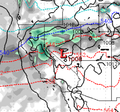
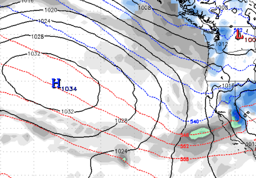
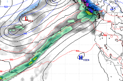
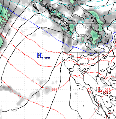
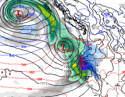
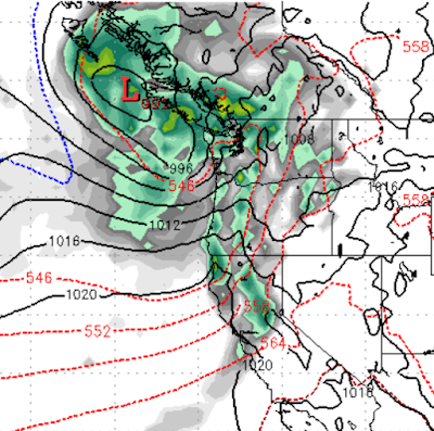
If we can learn a lesson about how Mother Nature works, it is that unusual weather is an oxymoron, while at the same time it is the only thing "normal". We avoid using the word normal, because there is nothing normal about weather. That is why we have averages. Enough philosophy. We have moved from a very warm dry pattern into a very cool wet pattern, seemingly overnight. We see no end in sight to this pattern. The next storm comes in early tomorrow and it will be even cooler: The EC model is more bullish on this next storm. Then the big storm comes in early on Sunday (12/12) morning. It will receive several re-enforcing shots of cold air and will tap into a sub-tropical moisture stream.  It will be giving us moderate to heavy precip for around 60 hours as here is the forecast for Tuesday (12/14) morning: You can see what happens when that ridge of high pressure is shoved west to around 150-155. A storm door is opened right to our front step. We believe that after this potent

Goodbye 60's, Hello Snow

Image
 If you have been following this blog, we have been tracking a weather pattern change for quite some time now. The models are converging and it looks like 4 separate storms are poised to hit Tahoe. Not any one of these storms is gigantic, but the sum of these storms should open a ton of terrain in the Tahoe area. The first storm is one we elected to ignore and it has overachieved. It will add 2-4 inches to Mt. Rose which is a welcome sight.  More importantly it will clear the way for the slider system that comes in Thursday night. This system is going to be accompanied by some very cold air. We will drop 30 degrees and mountain highs on Friday will be in the teens. In addition, expect 2-6 inches of snow for the leeward valleys and perhaps 6-8 inches of snow for Mt. Rose. Notice the ridge getting shoved west. That opens a real storm door and a week from today (Monday Dec. 13) we will see decent storm with low snow levels come into Tahoe. GFS is much more bullish but both it and the EC m

High Pressure Remains in Control, but for How Long?

Image
High Pressure remains in control. However, we are expecting a major pattern change to take shape about mid-week. We have been tracking this change for quite some time, and finally, it is knocking on the door. If you have enjoyed the beautiful late November early December weather ... it may be quite some time before we see 60's again. Here is our current pattern with 2 blocking highs and storms squeezing through into Northern Washington / Southern BC. All of this is going to change. Around Wednesday afternoon a major cold front will begin to move into the area. Our temps will go from 60's down to low 40's in a hurry. Best of all, the inversions which have been in place for some time will be pushed out allowing much cooler air for the mountains and the snowmaking machines. An eastern slider event will push down the leeward side of the Sierra and could bring some much needed snow. Probably no more than 6 inches, but we will take it. This cold front will change everything as ou

Stubborn Ridge of High Pressure Not Budging

Image
We had hoped this latest storm would shove our ridge of high pressure around a bit more; alas that is not the case. We are in a very stubborn weather pattern with little to no chance of precipitation for the next 1-2 weeks. Fear not, as the storms get stronger, they should be able to push that ridge further to the west and open a storm door. The next chance of that is around the 6th of December: Our confidence is pretty low for any sort of game changing event. This is the ECMWF model, which is the more reliable model, but other models are not in agreement. The other pattern shift we are looking at is around the 12th of December. That is too far out to comment for now. We will keep an eye out and report accordingly. Sorry, wish we had better news. I think Rose is getting close to opening, head over to Unofficial Rose for more. Stay Tuned...

When Will it Snow Again? Season Snowfall Forecast

Image
The question of the month is when will snow return to Lake Tahoe? Depending on your patience, this is either good or bad news; Currently high pressure is in complete control of the entire West Coast: Unfortunately, we see this blocking high moving only slightly. What does that mean? It means in the short term there is no significant precip coming to Tahoe. We do not predict man made snow, for that I suggest you go over to  Unofficial Rose . You can get the true heartbeat of the mountain there as well. We just due natural weather here. Now, if you are patient, we see a pattern shift begin around the 29th of November. Again this is still 9 days out, but our two most reliable models are forecasting this pattern change. Here is the forecast for Monday November 29th: This is the outer ring of a massive storm that is centered off the coast of Central BC. Between now and the 29th, if that storm moves a bit south we could see major precipitation. As it is, we should get a pretty decent shot of

Next Storm of Consequence Pushes in Monday Night

Image
What we are seeing today (11/6) is the leading edge of a larger storm. This leading edge could produce a few inches of snow for the Carson Range and Sierra. However a better storm is coming for Monday night: Later Monday evening the main front will push in. It has a decent moisture tap and should start out as all snow for Tahoe Resorts. However, as the front pushes through, it will pick up warmer air and snow levels will climb to around 7,000 or 8,000 feet. So this should be all snow for Mount Rose. How much snow? That is the question. The GFS weather model is much more bullish than the ECMWF and is calling for 1-2 feet for the Carson Range. The EC is calling for under a foot of snow. Let's hope for an over producer, because behind this front our ridge of high pressure will move into a blocking position. We do not see precipitation after this storm until around the 20th of November. Of course all that can change, because who's in charge? Not Us. Stay Tuned ...  

Several Glancing Blows Before a Real Storm Pushes In

Image
 We are in a stormy pattern with several storms headed our way. These are not like the last storm in that they do not carry the precipitation potential. We are looking at around 6 inches of snow for Mt. Rose between now and the 8th of November. Then a potentially larger storm comes in that could deliver a foot of snow or more. Our ridge of high pressure will need to flatten a bit prior to any storms making into Tahoe. So, for the next week the storms will just deliver us a glancing blow and for the most part, push north. That is not at all uncommon for this time of year. Our best chance of precip this week is very early Thursday (11/4) morning: The models have the leeward valleys being completed shadowed from precip, but the Carson Range could see a few inches, six at the most. Then around the 7th of November, our ridge flattens out which will allow storms to dip further south. How much is still up in the air: We expect several waves of precip to hit the Carson Range and possibly bring