Posts

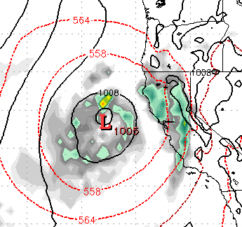
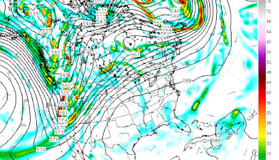
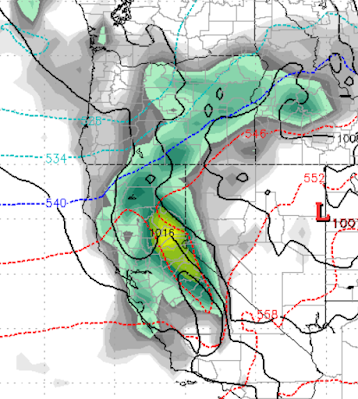
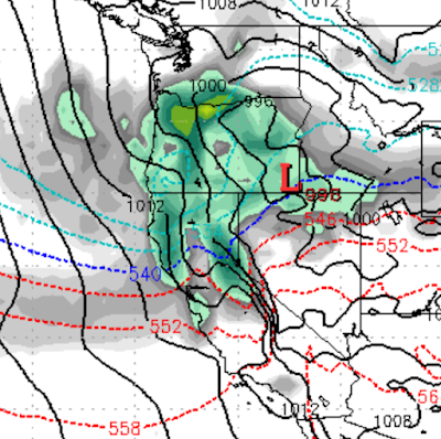
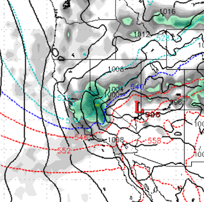
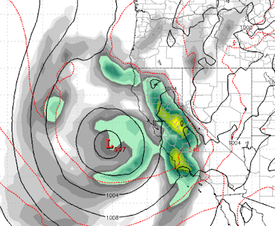
Much Needed Rains Put Pause on Fire Season

Image
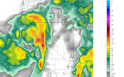
We still have 3 more days of rain that will bring up to an additional 3 inches of rain to the areas burning west of Lake Tahoe. Funny when Nature is pitted against Nature how nature always wins. Yes, nature uses fire to regenerate her forests, but only nature has the power to put out said fires. We should never forget who is in control and it is not us! This blog is now using a new delivery mechanism, follow.it , to deliver content to your email inbox. There will always be an unsubscribe link. You can also filter what you see as well:  https://follow.it/tahoe-weather-blog?action=followPub&filter Our old delivery service, feedburner, simply stopped delivering, therefore we have used follow.it as a Feedburner replacement .  We will be posting our 2022/2023 winter season forecast in the coming weeks. Stay Tuned ...

Weekend Storm Should Dampen Fires

Image
We have an early season storm that will drop down the coast and make landfall in Northern California. It will then move west directly over the fire areas. This storm should produce some precipitation, which will greatly aid the effort to put out these fires that are burning due west of Lake Tahoe. This storm will bring much cooler and more humid weather and the winds do not appear to be nearly as strong as once thought ... all good news. We are looking at from 24-36 hours of light rain and possibly some snow over the fire areas.  We are also looking at our first high mountain snows of the season. We see an above average snowfall winter for Tahoe, and will post our season predictions in the next few weeks after we aggregate all the data. Stay Tuned ...

It is a Good News Bad News Scenario for Smoke

Image
 I will be brief: The Bad News: Our winds will come almost directly from the west leading up to next weekend. That means the smoke could be here to stay for at least the next several days. Around Saturday a front moves in that will increase the winds and bring them more from the north. Of course that will make dealing with the Mosquito fire that much more difficult. The rainy season does not start for nearly 2 months. The Good News: We made it all the way to September before the air quality tanked. The winds could clear out the smoke toward the end of the week. There are several storms that should change our winds frequently in the coming weeks. Here is a look at the forecast winds for this weekend: Qualifier: Predicting local surface wind direction is very difficult. Stay Tuned ...

The Storm Door is Wide Open

Image
If this were January, this would be a major event. Truth be told, storms are just not that strong this time of year. However, we are in for several moderate events, especially considering it is mid-April. As my friend over at Unofficial Rose  put it, " Well it looks like we will get a week of January in April which I gotta say is classic Nevada weather. 75 one day, below freezing the next." Let's start with Saturday's storm. This is a stronger storm than the one that left around 7 inches on Slide Mountain: It is also warmer with snow levels creeping up above 7,000 feet. You can see the separation of warm and cold air, right now we are in the warmer air at the peak of the storm. All snow for Rose though. I would be remiss not to mention that prior to Saturday there will be a few waves of precip that could leave an inch or two. Saturday's storm could leave as much as a foot. Shadowing for Rose, does not appear to be in play. The next storm is on track for Tuesday. I

Seriously, 5 Storms in 15 Days

Image
After a very dry start to 2022 (following a record wet finish to 2021), Ma Nature, for some reason unknown to man has decided to bring the storms back. We are tracking 5 storms in the next 15 days. Tomorrow 4/11 @11am Thursday 4/14 @ 11am All snow for Mt. Rose, looking at snow elevations starting around 6000-7000 feet. Friday 4/15 @ 5pm This one looks pretty impressive from a moisture standpoint. Tuesday 4/19 @ 11am Typical Sierra split storm, going to give us more snow, could be a shadow effect for Carson Range, however. Sunday 4/24 @5pm Smallest and possible the last in this cycle, again, we are seeing some shadowing for Carson Range. Additional 3-6 feet of April snow for the Sierra in the next 2 weeks! Stay Tuned ...

Snow on Tap For Next Week

Image
As the resort ski season winds down, Ma Nature is saying, "not so fast". A Pacific storm will drop out of the north, pull up moisture and could well produce valley snow and will certainly produce mountain snow. This storm will NOT be shadowed so we expect precip throughout the Carson Range and even into the valleys.  This storm will continue to strengthen and will produce very heavy snow for the Rockies. For us, we are expecting 6-12 inches of snow for the Sierra and Carson Range. Mammoth will get around double that. There are places in the Rockies and central plains that could be looking at 4-5 feet of snow.  Notice the very cold air coming down from the north. Temperatures will be off by as much as 30-40 degrees compared to the last few days. Having said that, they will quickly recover to near or above average by late next week. What is most impressive about our storm, is it picks up strength as it moves across the West and into the Northern Plains. If this is snow for Sout

California to Get Nice Shot of Moisture

Image
  Early Monday Morning This storm showed some promise. However, like the last storm, it appears the Carson Range will be shadowed out. These storms just do not have the strength to hold together over the Sierra. This will allow some much needed moisture into California. As we get later into the season, the storms become weaker. Temps recover quickly, although not quite as warm as this past week. Stay Tuned ...