Posts

When Will El Nino Begin to Effect Our Weather?

Image
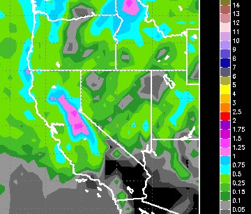
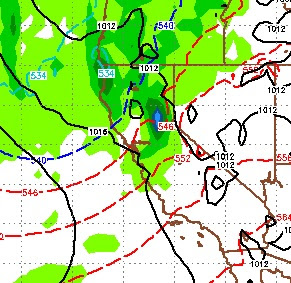
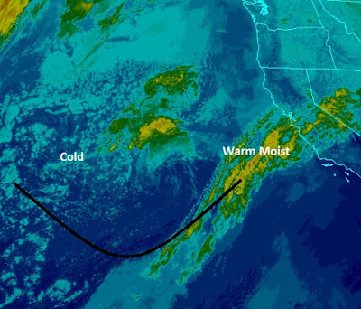
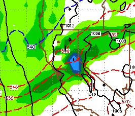
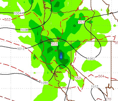
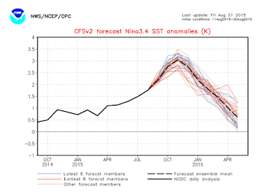
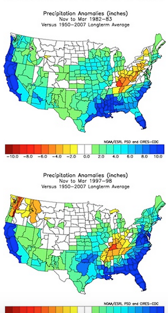
Contrary to popular belief, El Nino has had only a minor role in our most recent storms. These have been relatively small storms that found a moisture tap to the west and south. However, that is not what defines an El Nino influenced event. El Nino will take hold when the southern jet starts to influence our weather. That has yet to happen, so these storms are a real blessing. I receive a lot of very astute observations from some very smart people. One of the more interesting observations that I have seen came from BigSurHuntington. After looking at the last few strong El Nino years, he believes a pattern emerges. That pattern shows a break in the storm cycle while the southern "El Nino" jet stream moves up to influence our weather. After this break is when the heavy rains start. Because this jet is traditionally much further south, as it moves up, it brings copious amounts of moisture to the entire state of California. We are nowhere near there ... yet. To show you the p

Storm Update

Image
This storm has increased in strength and has tapped into a bit more moisture than I originally expected. It will come in 2 waves, one of which has already made it's appearance. The next wave starts this afternoon and will last into tomorrow. This has a little more potential to push into the Carson Range as well. We could be looking at around a foot of snow for Mt. Rose by storm's end. Here is the latest liquid precip forecast: This next wave will also usher in some very cold air, which will bring the snow ratio to about 15 to 1, thus we could receive about a foot of snow with 3/4 inch of liquid precip. This very cold storm is not unusual in El Nino years. I will explain why in my next post that will talk about when El Nino will begin to have a greater influence on our weather. Stay Tuned ...

Next Storm Will Be Here in 84 Hours, Weak for the Carson Range

Image
That headline says it all. The next storm is due to show up in Tahoe in about 84 hours or 3.5 days. Around Sunday at 4, the storm should arrive. Here is a look at the EC weather forecast for Sunday at 4:00pst: The models are in nearly complete agreement about this storm. Unfortunately for us on the Carson side of the Sierra, the bulk of this storm will not make it to us, so this will be a fairly minor event. I am thinking at most 6-12 inches for the Carson Range, probably though in the 3-5 inch range. The western crest, north of the Lake Tahoe could be looking at as much as 2 feet. Here is the precip total forecast: This storm does not have near the moisture plume to work with as the last storm. However, that should keep the snow levels much lower. The last storm stayed at 10,000 feet for the first half of the event or we would have seen much more snow, especially in the Carson range. Looking a bit further down the line, this is the only event forecast for at least the next

Storm Update

Image
I think this satellite picture says it all. Our storm has tapped into a moisture plume that stretches nearly to Hawaii (mini-pineapple expresss). Expect the storm to continue today. Snow levels will drop to the valley floor with little or no accumulation. However, I still expect the Mt. Rose ski area to pick up around 18 inches of base making, Sierra Cement. Temperatures will rapidly drop throughout today, A cold slider will come in late tomorrow/Wednesday that could produce additional snow for the Carson Range. The long range is forecasting this pattern to continue. Add El Nino influence starting mid-December and we could be looking at quite a winter in Tahoe. Many of the forecasters continue to warn of dire consequences when the storm machine really gets cranking. Remember, El Nino is warm and if you get a large snow pack to rapidly melt, that water goes down to the population areas. Be prepared. Stay Tuned ...

As Weather Pattern Changes, a Series of Storms are coming Our Way

Image
I apologize for lateness of this post, however I have been out of town and only returned yesterday. Looking at the latest model runs, I am most pleased by the amount of moisture the current storm appears to be tapping into, especially when it gets here. Here is a look a the latest run of the EC, for tomorrow: As this storm approaches, it will pick up moisture from the south. The model runs appear to be leaning toward the possibility of even a larger precipitation event. Also, this storm has plenty of spillover which bodes well for both the Carson Range and the leeward valleys from Reno through Carson. Here is a look at the current precip forecast, remember the models have been increasing moisture with each run, so our confidence is pretty high with this one: Not the most impressive storm ever, but certainly much better than what was being forecast 10 days ago. As far as snow levels, get used to this; this is a warm storm pulling moisture from the south. Snow levels will

Will Mt. Rose Open Next Week?

Image
First, let me apologize to my loyal readers. Generally when  you see that I posted that means a storm in on the horizon ... good times. Well, I keep hearing that a storm is coming next week and I want to set the record straight. From here on in, when you see the Tahoe Weather Blog posted in your inbox, you will know that I am seeing something. The question of the day, will Mt. Rose Open next week? In two words, probably not. Despite the first storm of the year coming in from the west, it is doubtful that this event will produce snow, let alone significant snow. The models are surprisingly consistent on this one. First a small system will approach from the west and track north. This system will not bring any precip to the Tahoe area. The next system should arrive next Wednesday. This is a larger system, but will break up and then head north. We will see cloudiness, but at this time, very little if any chance for measurable precip, especially on this side of the lake. Just because

El Nino Strengthens; Forecast to last through Winter of 2016

Image
Just a quick update. I want to expand upon what I was saying last post. El Nino is the real deal this year and should have a major impact on precipitation for most of California this winter. After a slight decline, another Kelvin Wave pushed El Nino into nearly uncharted waters. If you look at last post, only two years have compared with this El Nino. This El Nino could be stronger. The one variable that was not in play during 82/83 & 97/98 were the extremely warm California coastal waters. Most experts believe this will add to the extreme weather effects that have been associated with El Nino's similar to this one. Here is what impresses me; The forecast peak of this El Nino will come right in the heart of our rainy season. Take a look at the latest chart from NOAA below. If we hit some of those upper outliers, we are talking about an event previously unseen. Stay Tuned ...

Will Averages Begin to Catch Up for California? Are We Experiencing Man-Made Global Warming?

Image
After four years of drought, most of California is under a water emergency. However, we are seeing indications that at least some relief is in sight for the short run and the long run. First, let's get some facts straight; California is mostly a desert. The drought stricken areas along the southern coast are deserts that have been radically over populated by man. We have decimated the geography by covering it in concrete and planting thousands of different varieties of non-indigenous plants. We have polluted the air and ground. In short, man has not been good to this area and there is no argument for that. The weather in this area is so nice in both the winter and summer that it is a very highly desirable place to live. Extended dry periods in deserts are not that uncommon. However, when you have over 30 million people living there they tend to be catastrophic. The San Francisco Bay area is not much different. It gets more annual rainfall (on average) than Southern California,

Sometimes Mother Nature Ignores our Schedules

Image
We are in a very strange weather pattern indeed! It has been raining for a couple of weeks in the desert, snowing in the higher elevations. Ironically, this pattern is from a series of low pressure systems that occupy the entire west right now. The real culprit is a strong storm centered near the four corners region. This storm is pulling moist air up from the south and wrapping that moisture around, right into the state of Nevada and much of the west. This storm is near stationary, so expect this pattern to continue through at least tomorrow. Unfortunately, California is being left out of this current event for the most part. When will it end? First, there is a warming trend coming as the Jet dives south and this storm begins to move north and east. However, from what I can see it is in no hurry. So I expect warmer temps (still below average) to move in, but the chance of rain will continue through next Friday, albeit nothing like what we have seen this week. After that, th