Ridge City Coming - That Means More Mild, Seasonal Weather
Two strong high pressure ridges are headed our way. Golfers and warm weather lovers rejoice. The first builds in late Saturday into Sunday. The following image shows the ridge off the coast of California. Notice how all the stormy weather bounces off the ridge and moves around it:
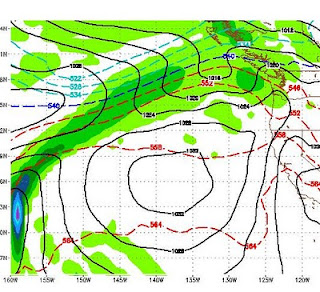
Eventually this ridge breaks down and moves on. However, almost immediately after that, another stronger ridge will build in almost the same spot. Here is a snapshot for a week from Saturday:

For you warm weather lovers, this should bring some 80's to the region. Between these high pressure ridges, we will see some wind but nothing like we have seen for the last month. There is little or no chance of significant precipitation for at least the next 10 days as temperatures will warm, fall off slightly and then get even warmer.
For you skiers and riders, today Scott and I went up to Alpine Meadows and caught fresh lines for at least 3 hours. Although the snow was variable and dependent on the elevation, we were not complaining on the last day of April. Have a look:

This time of year it is especially difficult to predict weather. With El Nino still at the moderate level (but weakening) we will still see a couple of more storms by the end of May. Mammoth has announced that they will stay open through the 4th of July.
I will be posting some columns that explain the science, or lack thereof, of global warming. That should come in multiple parts through the summer when there is no weather to report!!!
Stay tuned ...