Major Pattern Change in Store for Tahoe
After a fairly prolonged dry spell, the weather is about to change. A series of storms are headed our way that should bring significant snow to the Sierra.
Starting tonight and lasting until Friday, we will see light to moderate snow. Then, starting on Friday night, a much larger precipitation event will occur.
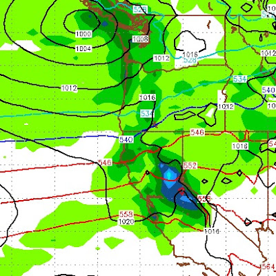
Here is the forecast for very late on Friday:

That storm to our north and west will stall and pick up moisture and bring that moisture straight into Tahoe. By Saturday afternoon things will look like this:
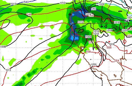
Things will settle down slightly from Sunday afternoon through Monday, then a warmer storm approaches us from the south and west that is packed with moisture. This could turn into an atmospheric river event which Paul talked about in his last post. Here is a look at Tuesday morning, notice the moisture tail:

Currently, the models have this storm going slightly north of us, but I believe we could well be in the Bullseye for this event.
Beyond that, the storms appear to be stacked up and should continue, here is the 10-day precipitation forecast:

The Sierra, especially northwest of Lake Tahoe could see areas that pick up in excess of 10 inches of liquid precip. Some areas of the High Sierra will see in excess of 10 feet of snow.
To illustrate the nature of this pattern change, here is the 30-day precip outlook:

Before the month ends, most areas of the north and central Sierra should see 10 feet of snow or more above 8,000 feet.
The only downside of these events, is they will be coming with fairly warm air. I think the Mt. Rose should be OK for all snow as these events occur. However, some snow levels could reach 8,000 feet and possibly above.
We will file another report, pinpointing snow elevations in the next day or so.
Stay Tuned ...
Starting tonight and lasting until Friday, we will see light to moderate snow. Then, starting on Friday night, a much larger precipitation event will occur.
Here is the forecast for very late on Friday:

That storm to our north and west will stall and pick up moisture and bring that moisture straight into Tahoe. By Saturday afternoon things will look like this:

Things will settle down slightly from Sunday afternoon through Monday, then a warmer storm approaches us from the south and west that is packed with moisture. This could turn into an atmospheric river event which Paul talked about in his last post. Here is a look at Tuesday morning, notice the moisture tail:
Currently, the models have this storm going slightly north of us, but I believe we could well be in the Bullseye for this event.
Beyond that, the storms appear to be stacked up and should continue, here is the 10-day precipitation forecast:

The Sierra, especially northwest of Lake Tahoe could see areas that pick up in excess of 10 inches of liquid precip. Some areas of the High Sierra will see in excess of 10 feet of snow.
To illustrate the nature of this pattern change, here is the 30-day precip outlook:

Before the month ends, most areas of the north and central Sierra should see 10 feet of snow or more above 8,000 feet.
The only downside of these events, is they will be coming with fairly warm air. I think the Mt. Rose should be OK for all snow as these events occur. However, some snow levels could reach 8,000 feet and possibly above.
We will file another report, pinpointing snow elevations in the next day or so.
Stay Tuned ...