Significant Storm(s) Knocking on the Door; Record March?
The NWS has issued a blizzard warning for the leeward valleys of Northern Nevada. These guys are professionals and are very good at what they do. In addition, we are looking at the possibility of over 10 feet of snow for the Sierra, including the Carson range.
Our forecast is mountain snow through March 15th on most days! We could see an additional 10-15 feet of snow on Mt. Rose by the middle of March.
Here is some timing:
Thursday Night 2/29

The storm approaches and begins to slam the West side of Lake Tahoe. Even the leading edge of this storm is cold, we see initial snow levels below Lake Tahoe, which is great news for all resorts.
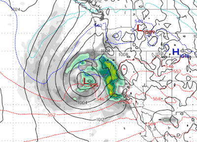
Friday Late Afternoon 3/1

The storm stalls and gathers steam. This portion of the storm will deliver very significant snowfall over the Sierra. Snow begins in the Leeward valleys after starting with rain.
Saturday Night 3/2

The storm remains stalled. Notice how the cold air meets the warm air right over Lake Tahoe. What a party this will be!
Sunday Evening 3/3

Storm begins to move on shore. However, this is when the storm splits sending another wave of precip straight into Lake Tahoe.
Tuesday Morning 3/5

Thursday Morning 3/7
Expect about a week's worth of snow starting Thursday night.
There are more storms on the horizon lasting through about the middle of March.
Stay Tuned ...