Posts

One Last Storm Before Dry Conditions and Warming Trend

Image
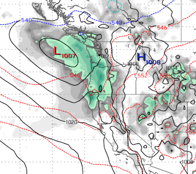
This has been quite the weather smorgasbord. We had 3 troughs of low pressure a blocking ridge of high pressure and a dance in the Pacific off the West Coast of the US with all these weather systems. I give the models some credit, they pegged it pretty well. We are now looking at what could be one more decent storm before a much drier and much warmer weather trend. Here is the forecast for early Tuesday morning. This storm has a great moisture tap and will come in warm as is usually the case when we have the potential for major precipitation. All models are pointing to a major snow storm for Mammoth. We are uncertain on the amount of snow we will see up in Tahoe. Right now it looks like about 1-2 feet on the crest and 6-8 inches for Slide Mountain. Ironically, the storm earlier in the week pounded areas north of Lake Tahoe, while this storm will pound areas south of Lake Tahoe. Of course Mother Nature is in charge and a slight shift north would bring much more snow. The Carson Range ha...

Heavy Snow For the Carson Range Expected Through Saturday

Image
A massive storm, that we talked about last post is slamming Northern California. Despite the strength of this storm, much of the Carson Range has been shadowed out. That is about to change. The last big wave will be sliding south and will produce heavy snow above 7,500 and will cross over the Sierra and Lake Tahoe and should bring about 3-5 feet of snow to Slide Mountain by late Saturday night. The heaviest snow will last from about 7pm tomorrow through the early morning hours Saturday. We will get a short break before this same storm gathers and brings a lighter wave of precip to most of the Sierra from late Sunday through all of Monday. We could pick up an additional foot in the Carson Range, however we will be shadowed out again from the really big stuff. Thanksgiving now looks dry so the pattern will change back to a blocking ridge of high pressure. These next few storms need to produce some heavy amounts of snow if we want superior skiing and riding after Thanksgiving. The dry pat...

Wednesday Will Usher in Pattern Change

Image
We are about to enter a stormy pattern that looks like it will last for the next couple of weeks. Here is the forecast for Wednesday early morning (11/20), notice the two ridges of high pressure to the east and south. That will allow this storm to stall: Next wave is forecast to come in on Saturday morning: Another wave is scheduled for Sunday night: We could be looking at storms through the Thanksgiving weekend. The models are in alignment through Saturday. We will keep an eye out for a possible major storm for Thanksgiving. Right now we are looking at about 3-5 feet in the next few weeks.  These storms are on the warm side. We are confident this will be all snow, however, for Mt. Rose. High base matters! Stay Tuned ...

Storm For Monday and Seasonal Outlook

Image
First things first, there is a storm that will come in and deliver around 6 inches of snow to Slide Mountain on Monday afternoon. We will take all we can get! Mt. Rose high base will come in handy as this storm will begin on the warm side. I am not seeing any large storms after that for a few weeks. Luckily I have a crystal ball that can look quite a ways into the future. What I am seeing is a pattern change. Currently, we have our persistent ridge of high pressure that is blocking storms from making it down this far south. The pattern could change around Thanksgiving as the ridge breaks down and a series of storms could enter our area. Here is a look at the forecast for Thanksgiving day. Winter Outlook As we look toward the upcoming winter, what are we seeing? We have been pretty lucky with our winter forecasts the last several years. Disclaimer: Ma Nature is in charge! For starters we are going to see a moderate to strong La Nina. What does that mean? In short it means the surface te...

Today is Windiest; Much Cooler More Humid Air Tonight and Tomorrow; More Wind Starting Sunday

Image
 The Davis Fire, is currently at 31% containment. It jumped Mt. Rose Highway but that was quickly extinguished. However, winds are about to pick up. That is the bad news. The good news is they will die down this evening. We are looking at 25Kt winds for this afternoon and through most of the evening. Then the winds are forecast to calm by 11pm. Here is the the forecast for this afternoon and evening: As you can clearly see, winds will be coming from the west to southwest.  However, the models are pretty clear that the winds will calm as we move into later tonight. Here is the wind forecast for 11pm: Winds should calm down considerably. The European model has much lighter winds. We are expecting winds in the 20kt range with gusts to 35kts through about 6:00. Then they will begin to die down. This is not what was forecast elsewhere, but I am not sure what models they are looking at. I am not a fire expert, but I do NOT expect the gloom and doom that was presented in last nights ...

If You Think El Nino is Done With Us; Think Again

Image
What a beautiful run of spring weather! Don't get used to it. It is coming to a screeching halt on Friday. We see a pretty major pattern change that will bring the possibility of a few strong storms to the Sierra and even over to the Carson Range. One thing for sure, your upper 70's (in the valley) will be replaced with upper 50's with lots of wind. Here is a look at the forecast for Thursday. That trough of low pressure is going to change everything. Behind it is a significant cold front that will bring our temperatures down below average for at least the next few weeks. It will open the door for more storms that have some potential to bring in a late season Sierra Snow Storm. We will really feel the pinch next week around Tuesday. Notice the cold air (light blue line) heading to our area. That is typical of what we may see in January. Finally, as the storm door stays open and our weather is dominated by air from the north: This system could usher in a major storm. That st...

Significant Cold Front with Some Precipitation Headed Our Way

Image
 Enjoy the warm, sunny weather. It is not going to last. We have been talking about a cold front which will make it's way to our area starting later on the 4th. With that cold front we are talking about some precipitation as well.  Temperatures should bounce back around the 9th of the month and go above average again. I would probably wait on turning on your irrigation until at least then. Here is a look at the forecast for Thursday evening (4/4): This will be our best chance for precipitation and we will see at least a few flakes all the way down to the valley floor as the cold front moves through on Thursday night and Friday. By the 11th of April, our temperatures should be back above average. As we move later in the season, our storms will be weaker. However, Ma Nature always spins up a surprise when we least expect it. As far as seasonal averages are concerned, we are now above average in precipitation for our 2nd straight year. Of course 3 years ago we were slightly below...