Major Pattern Shift Begins Wednesday Night

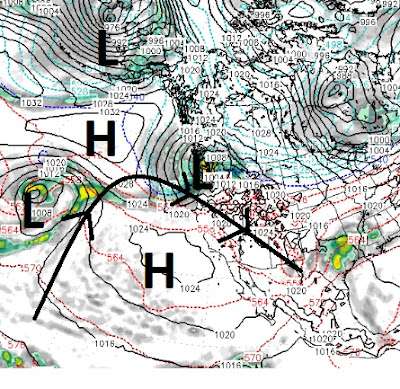
We have been locked under this coastal ridge of high pressure for weeks now, but as with all things related to weather that is about to change. The change begins slowly on Wednesday night with a weak system coming from the south. Although this system has plenty of moisture to work with, it is too weak to expect anything of significance. We are much more impressed with what starts around Friday at noon and could last up to 30 hours: Here is the forecast for early Friday Morning: Again, this is another weaker system, but does have some potential for precip. Both these system are going to be very warm with snow levels starting around 8,000 feet or possibly slightly lower. Mt. Rose will probably be the big winner again. We are tracking a storm for just over a week from now that looks very positive. It has cold air, energy and moisture with which to work. Usually that combination can usher in much needed heavy snow for the Sierra. Here is a look at the forecast model for a week ...