Posts

Storms Update

Image
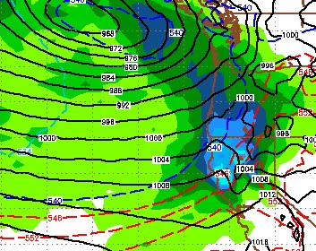
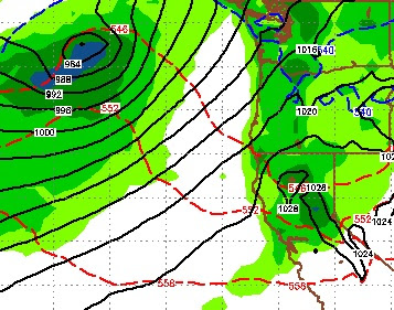
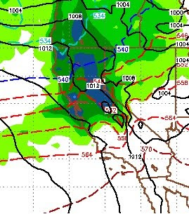
The winter storm that is knocking on our door right now is on track to produce heavy snow for the Lake Tahoe area. For most of Tahoe its arrival will be early tomorrow morning. Amazingly the EC model nutted this thing over a week ago and the timing is nearly perfect. Here is a look at the forecast for early tomorrow morning: This is a strong storm that is tapping into a subtropical moisture plume. In fact take a look at the satellite right now: You can see our next storm located off the Oregon and Washington coast. This is a bigger storm and will bring even more snow to Tahoe. For the Carson Range, this will be all snow above 7000 feet. Snow levels will start there or slightly higher and quickly fall. In addition, the shadowing effect, which has been prevalent for our last few storms, will not be so strong. So I look for heavy snow in the Carson range through next Tuesday. There will be a slight break, but the 2nd storm will arrive Sunday in the early afternoon. Here is a l

Stormy Week Ahead

Image
As the models converge on a very stormy week, we are starting to see indications that the rains from the western Pacific are starting to make it here with a little bit more strength. First lets look at the upcoming week. There are a series of waves headed our way: Sunday Dec 6, 12:00pm This storm will be much better for the west shore of the lake but I still expect 2-4 inches for the Carson Range, 12-18 for the Western Crest of the Sierra. There will be a series of these small shortwaves that will be cast our way. We should pick up another few inches ahead of a much bigger storm that we have been talking about for a few days now. Thursday Dec 10, 12:00pm This is the best chance we have of a major storm. This will pick up moisture steaming across the Pacific and should deposit it all over Tahoe, including the Carson Range and Mt. Rose. I am looking for 10-20 inches out of this (Carson Range) and if things align perfectly,

Fast Moving Storm Will Bring Wind, Cold and Snow

Image
This storm that is knocking on the door will be here and gone before you know it. However, there is some moisture associated with this storm that could see snowfall rates around 2 inches per hour for several hours, especially north and west of Lake Tahoe near the Sierra Crest. Shadowing is strong, so precip amounts will be much less for the Carson Range. We could be talking 2 feet for the western crest and about 6-8 inches for the Northern Carson Range. The good news on several model runs today is it appears next week could bring us a series of shortwave events ending with a warm, wet storm around the 10th of the month. This is a much better solution that what we have been looking at for the last week, and perhaps the long range will pick up on a very fluid weather pattern. One thing is for sure, the Pacific Northwest is going to be exceptionally wet and rainy. Some models are showing 2 feet of liquid precipitation for Washington State over the next 10 days. We are hoping that the pa