Posts

No End in Sight For Storm Train; Warmer, Wetter Storms Come in next Week

Image
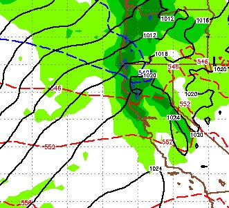
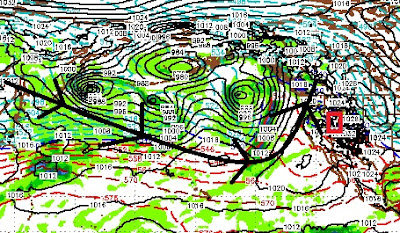
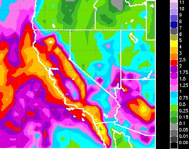
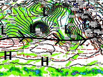
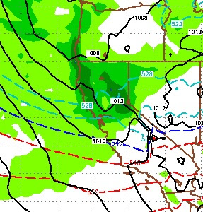
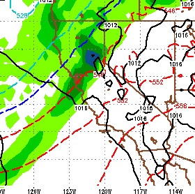
Everybody said we were crazy with our 18-36 storm total for the Carson Range; but we were pretty darn close as it turns out. That was a great 1-2 punch and the snow is starting to pile up. There is no end in sight for the storm train as we are tracking storms for early tomorrow, Sunday-Tuesday, and late next Friday. The later two storms are showing much more liquid precip. However, these will be warmer storms and snow levels will rise to around Lake Level. Because of the amount of warm moisture these storms are bringing in, I would not be surprised if snow levels started in the 7,000 foot range. But, let's no get ahead of ourselves. We already have another storm knocking on our door and it will arrive in Tahoe very late tonight through tomorrow. Here is a look at the forecast for around noon tomorrow. This is a weaker storm but is cutting a nice path for the storm on Sunday: I expect the lifts at Mt. Rose to stay open tomorrow. However, this storm will bring only around 3-

Storm Train is Barreling Down the Tracks

Image
Starting on Wednesday, we should see much more precip as El Nino begins to strengthen his grip. For Wednesday and Thursday we are looking at a decent snow event for both the Sierra and Carson Range (18-36 inches). Here is a look at the forecast for Wednesday afternoon: Following this system are a couple of weak short waves that will keep it cloudy and snowy in the mountains until the next system on Saturday morning: This system also has some potential for another 1-2 feet. Again, another series of weaker short waves will keep things snowy in the mountains and then the next system will arrive a week from tomorrow: There is a number of other systems that just keep lining up so I expect this pattern to continue. Over the next 8 days here is what we can expect in the way of liquid precip: Southern California is getting the short end of the stick with this pattern, but Southern California is a desert, no different than Reno and Carson City. However, we can look for any

Expect More of the Same

Image
A series of storms are lined up and heading our way. These are fairly weak storms and none of them has the potential to dump 5 feet. However, they just keep coming and it adds up in a pretty big hurry. I am tracking storms for Saturday (late morning), Tuesday (Early Morning) and the biggest of the bunch early next Wednesday morning. Here is a look at the storm track: This appears as though the storms will be cutting north, and not delivering their payload to Southern California. Tahoe is highlighted in red. I hope this storm track changes, and our researchers believe it will, just not in the next week. I guess we will just have to live with all the snow coming our way! Here is a look at the storm on tap for next Wednesday: This storm train will make it seem like it is snowing in the mountains constantly. And, quite frankly, it is snowing in the mountains constantly. Head over to  Unofficial Mt. Rose  to see how awesome the conditions have been. Finally here is the outlook

Storms Update

Image
A series of storms are coming. We believe we will see significant precipitation over the next 3 weeks and beyond. We are looking at the possibility of as much as 8-15 feet of snow for the Sierra Crest around Lake Tahoe by months end. Or we could see more! These storms should easily push through and leave similar totals in the Carson Range. The short-term, good news is that until about mid January these will continue to be cold storms. Snow levels will be in the 5,000-6,000 foot range, great for all Tahoe Ski Areas. In addition, the largest of the storms for the next week, Tomorrow's storm, will not bring in the 100 mph winds. I believe that the lifts will continue to spin at Mt. Rose through the storm. Qualifier: Exact wind conditions are very difficult to predict, so cross your fingers if you are planning on going up tomorrow. Around the 15th, our researchers are seeing a change in the pattern to a much wetter, warmer pattern with the Pineapple Express coming into play. The bi

El Nino Begins To Influence Our Weather

Image
Our weather will begin to come in from the west and south and with it will come tropical moisture as El Nino begins to dominate the pattern. In fact, starting late Monday and lasting into the foreseeable future, it is going to rain in the lower elevations and snow in the upper elevations. Here is a look at the Pacific: If you look at my previous post, this is a complete turnaround. In fact, our persistent ridge of high pressure is not even in the picture. We have not seen a pattern like this in many years and it is a very welcome pattern for Southern California as the westerlies will bring much needed rain. This El Nino is setting up to be historic insofar as moisture. Already areas around the Indian Ocean and western Pacific have seen historic rainfall (and flooding) and at least one of my researchers believes this is coming to California. Before I show you the 10 day precip forecast from the GFS weather model, let me say this; almost all of the forecasters and for

One More Storm, Then Cold, Dry Period

Image
We have one more storm on tap. That storm will usher in very cold air and move quickly through the area. Unfortunately, this storm is moisture starved. Here is a look at the forecast for about noon on Christmas Eve: This storm will quickly exit our area and leave behind very cold air and very deep valley inversions, especially this coming weekend. Winds will not be nearly as strong and there is a good chance that the lifts keep spinning on Christmas Eve day, during the storm. With the heavy snow we received over the last several days, Christmas day could bring a champagne powder day. For all things powder, be sure to visit the best Mt. Rose site:  Unofficial Mt. Rose , they will let you know if the lifts are spinning and the kind of conditions that can be expected. I am expeciting 6-12 inches of very light powder for the Carson Range starting around 8:00am on Christmas eve and ending that evening. I see a lot of cold and no major storms perhaps through the end of the year. Howev

Warm, Wet Pattern Starts Tomorrow

Image
A series of weaker, warmer storms are headed our way that will bring snow to most of the Sierra and rain to the valleys. The big question is how much snow? My answer is: A lot. First allow me my disclaimer, the models are all over the place, there is serious moisture available for any storms headed our way and there are several storms poised to hit. The first of these systems comes in late Friday or very early Saturday. That system will weaken and clip Tahoe. Most of the precip will stay west of the lake but I do expect some accumulating snow for the Carson range. Here is a look at the forecast for midnight on Friday: This will stick with us for some time as the pattern is very wet. Look for snow or snow showers all the way up to the 24th. At that time a larger storm comes in and has great potential for really hitting Tahoe on Christmas Eve or thereabouts. Here is a look at the forecast for the morning of the 24th. This storm will move into Tahoe on the 23rd, pick up moisture