One More Storm, Then Cold, Dry Period
We have one more storm on tap. That storm will usher in very cold air and move quickly through the area. Unfortunately, this storm is moisture starved. Here is a look at the forecast for about noon on Christmas Eve:

This storm will quickly exit our area and leave behind very cold air and very deep valley inversions, especially this coming weekend. Winds will not be nearly as strong and there is a good chance that the lifts keep spinning on Christmas Eve day, during the storm. With the heavy snow we received over the last several days, Christmas day could bring a champagne powder day. For all things powder, be sure to visit the best Mt. Rose site: Unofficial Mt. Rose, they will let you know if the lifts are spinning and the kind of conditions that can be expected. I am expeciting 6-12 inches of very light powder for the Carson Range starting around 8:00am on Christmas eve and ending that evening.
I see a lot of cold and no major storms perhaps through the end of the year. However, that can change! Also, if you read my post on the last two El Ninos, about this time was when things dried out. Then the deluge happened for 3 months!
This past storm was certainly what we can expect from an El Nino winter. However, I am very hesitant to say that El Nino is here. My researchers tell me that the moisture in the Western Pacific has not reached our area yet, but small amounts continue to trickle in, like this past storm. Take a look at the upcoming forecast for the Pacific:

You can clearly see the Northern jet as it goes up and around our ridge of high pressure. This is hardly an El Nino pattern as no moisture is coming in from the south. These are typical storms for this time of year. Tahoe is outlined to the right.
As our snowpack continues to grow, with cooler temperatures and frequent storms, I am continually being warned about the chance of a late February or early March event that could bring heavy rains to the upper elevations of the Sierra and cause massive flooding in California. In addition, all that snow pack will wash straight into the ocean. Let's hope this does not happen, but it would not hurt to be prepared.
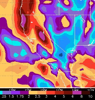
Fantasy Forecast
The long term forecast has the storms continuing. This is the 30 day precip forecast total. The Carson Range is clearly in the 6-8 inch range, while the western crest looks to be in the 8-10 inch range.
Will this pattern continue through April?
Stay Tuned ...

This storm will quickly exit our area and leave behind very cold air and very deep valley inversions, especially this coming weekend. Winds will not be nearly as strong and there is a good chance that the lifts keep spinning on Christmas Eve day, during the storm. With the heavy snow we received over the last several days, Christmas day could bring a champagne powder day. For all things powder, be sure to visit the best Mt. Rose site: Unofficial Mt. Rose, they will let you know if the lifts are spinning and the kind of conditions that can be expected. I am expeciting 6-12 inches of very light powder for the Carson Range starting around 8:00am on Christmas eve and ending that evening.
I see a lot of cold and no major storms perhaps through the end of the year. However, that can change! Also, if you read my post on the last two El Ninos, about this time was when things dried out. Then the deluge happened for 3 months!
This past storm was certainly what we can expect from an El Nino winter. However, I am very hesitant to say that El Nino is here. My researchers tell me that the moisture in the Western Pacific has not reached our area yet, but small amounts continue to trickle in, like this past storm. Take a look at the upcoming forecast for the Pacific:

You can clearly see the Northern jet as it goes up and around our ridge of high pressure. This is hardly an El Nino pattern as no moisture is coming in from the south. These are typical storms for this time of year. Tahoe is outlined to the right.
As our snowpack continues to grow, with cooler temperatures and frequent storms, I am continually being warned about the chance of a late February or early March event that could bring heavy rains to the upper elevations of the Sierra and cause massive flooding in California. In addition, all that snow pack will wash straight into the ocean. Let's hope this does not happen, but it would not hurt to be prepared.
Fantasy Forecast
The long term forecast has the storms continuing. This is the 30 day precip forecast total. The Carson Range is clearly in the 6-8 inch range, while the western crest looks to be in the 8-10 inch range.

Will this pattern continue through April?
Stay Tuned ...