Posts

Fall/Winter 2017-2018 Update - Walker Circulation Strengthens Suggesting Wet Cold Start and Drier Late Winter

Image
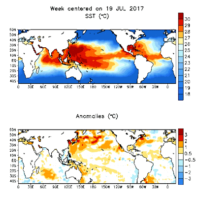
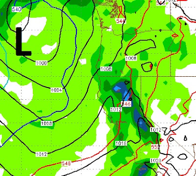
By Paul Huntington I just wanted to highlight some recent atmospheric and oceanic observations that point toward a "possible" drier than average Winter for Central California with cooler northern storms (Inside Sliders) rotating down from the Aleutian Islands and less atmospheric rivers than last year, however the Madden Julian Oscillation (MJO)--that has been fairly quiet and inactive recently- is showing signs of waking back up along the Intertropical Convergence Zone (ITCZ) in proximity of the Maritime/Indonesia region or West Pacific along with the upwelling directly off Peru (localized El Nino) slowing down allowing warm sea surface temperatures to establish within the far eastern equatorial Pacific Ocean. Meaning things could change late Fall into Winter and recently our wind patterns/oceans have been showing tendencies toward strong variability in the strengths of El Nino indices- and even going from medium strength La Nina to very strong localized coastal El Nino of

When Will the Storm Machine Start Cranking?

Image
Although it has been a cool fall, we have not seen any winter storms thus far. Currently we have our persistent ridge of high pressure blocking storms and forcing them north, take a look:  However, I am seeing a change in that pattern with two storms, one from the south and one from the north, squeezing that ridge out to sea. That change looks to be around the 19th or 20th of October. The massive storm in the image above, will move south and split into a large and small storm. The smaller storm will move way south while the larger storm will come ashore in Washington. Here is a look at the forecast for very early on the 18th: The storm to the north will drop a wave south, right into the Tahoe area. That will pick up sub-tropical moisture and deliver it to the Sierra. Here is a look at the 19th of October: I do not expect any major precipitation, but we could see up to a foot in the Carson Range, as this storm's trajectory looks pretty good. This is an early season

Winter 2017/2018 Outlook

Image
By Paul Huntington What is next Winter going to bring to the mid latitudes in the Northern Hemisphere and how are the large planetary waves going to behave? Planetary waves are the oscillations in the jet stream around the mid latitudes (Westerlies) that bring either high pressure (ridging) or low pressures (troughing) in the atmosphere and behave much different than the low pressures around the equator that form more from very warm ocean surface water and air condensing into water vapor/clouds and large cumulus thunderstorms/cyclones that create a feedback loop called the Madden Julian Oscillation (MJO), this reverberant affect propagates eastward around the equatorial world kind of like a stack of dominoes folding upon one another. It is very hard to predict when and where it might find a comfortable region stalling out and influencing the Northern Hemispheres Jet stream dynamics but seems to be acting up recently and could be a major player in the extension of the Asia Pacif

Storm Begins June 8-9, Report on Global Specific Humidity

Image
By Paul Huntington Starting on June 8 Thursday a big pattern change is taking place with a very unseasonable strong low pressure rotating down from Aleutians and could bring as much as a foot of snow above 8000 ft, adding even more white stuff to our already incredibly large snow pack in the Sierra. The meridional angle (El Nino type trajectory) of the jet stream in the North Pacific is following a very similar path to what brought us saturated air masses throughout the Winter in 2016-2017. Moreover, it seems the Arctic Oscillation is finding a quasi equilibrium more around negative than positive meaning the pressure gradient in the North Pacific on the southerly extent of the northern hemispheric jet stream (westerlies) is lower than average thus allowing the jet stream to dip down into California. Also the Antarctica Oscillation is finding a quasi equilibrium in the positive (climate change and a warming planet could be fueling this pattern change) meaning the jet stream is hugging

Weak System then Beginning of Summer

A weak, moisture starved system, which is being completely oversold by the local media, will come in tomorrow and clear out by early Wednesday morning. Temperatures will drop, especially in the mountains, but this is nothing like what we have seen this winter. Starting Wednesday afternoon we see high pressure taking over and we could see our first 90's by late in the weekend or early next week. Stay Tuned ...

7 Days of Bad Weather Starts Tomorrow

Image
We hope you enjoyed these last few days, because the warm sunshine is going to give way to West  Coast Troughing starting tomorrow. For about the next 7 days temps will struggle to get out of the 50's with cloudy, windy, cool and even rainy conditions. Perfect for getting those last turns of the season at Mt. Rose! This stormy, cool weather will culminate with at least a reasonable chance for some rain and snow next Tuesday afternoon. Here is the forecast for Tuesday afternoon: This is a slider type system that will drop out of the north and really make us question if it is really May. As the season winds down and the weather begins to stabilize, our posts will decrease as there just is not much to talk about. However, rest assured we are keeping a very close eye on next winter. If you read Paul Huntington's post from last week, there are several reasons to believe, that this years record precipitation may also be on tap for next year. Stay Tuned ...

Cool, Wet Weather to Return Next Weekend. Six Teleconnections that Suggest this Winter's Pattern Continues!

Image
Report by Paul Huntington I am seeing some interesting active late season weather beginning around Saturday May 6 and continuing for a couple weeks into Middle or even late May. These wont be huge storms like this winter but more cool showery lows with embedded thunderstorms and enough to warrant people to question "What is happening to our climate system?" Once again the global teleconnections are again in perfect alignment for troughing along the West Coast of North America. Yes, I know its time for Spring and warmer weather but we might need to wait- albeit this weeks heat spike- till June. The pattern that is unfolding is very similar to what brought us rains throughout our Winter and doesn't seem to want to budge. The climatic pattern taking shape in the North Pacific is supported by the Negative phase of the Arctic Oscillation or a weakening pressure gradient between the North Polar low and southerly high in the Central North Pacific along with the North Atlanti

3 Weak, Moisture Starved Systems Heading Our Way

Image
We have 3 systems that will move quickly through and have a slight impact on the area. I do not see any major snowfall amounts in any one given time period, however the total of all 3 systems will leave us with more snow in the Carson Range and Sierra. Let's focus on the total precip and snow levels. Mt. Rose will receive all snow. For the most part snow levels will be around 6,500-7,000 feet. However, the 2nd system could bring in some warmer air and snow levels could jump to 7,500 feet late tomorrow or early Tuesday. Here is the precip forecast: Some areas of the High Sierra, around the western crest could see as much as 3 additional feet. Those areas, above 9,000 feet have picked up so much snow this season, that 3 feet is like a few inches anywhere else. It is interesting that Mt. Rose has led North America in snowfall amounts, because the highest peaks, west of Lake Tahoe at the crest of the Sierra have picked up much more snow, perhaps some areas in the 1,000 inch ra

Next Storm Coming Late on Wednesday

Image
We are tracking 3 storms right now for next Wednesday, then a week from today and then, perhaps, the 21st of April. The last storm hooked up nicely with a moisture tap and we see something similar for the storm next week, although probably not as much moisture by about half. Here is the forecast for late Wednesday night: A decent moisture connection, but nothing like what we saw in the last storm. Snow levels for this one should be around 6,500 at the start and fall to around 5,000 feet as the cold front passes through. That means the leeward foothills can expect more snow on the ground. The following Sunday night see's the next storm come in. This storm does not have the moisture associated with it and will only bring in more cool air. I see light amounts of snow and lot of wind. Here is the forecast for Sunday afternoon as the storm approaches: The last storm we are tracking could show up on the 21st and may bring a return to the moisture tap, we will have to wait a

Storm Track Shifts North, Storms Stacking Up

Image
The storm track for our latest weather system has shifted north and Tahoe is now right in the bullseye of the storm. This is a major storm for this time of year and will last through most of Saturday with high winds and lots of precip, mostly snow above 7,000 and perhaps lower. Most of the major precip should be over by late Saturday afternoon. However, we are talking about a lot of rain and mountain snow between now and then. The possibility exists for a major snow event for the leeward foothills around 5,500 feet and above as the NWS is having difficulty pinpointing snow levels with this very unusual storm. If you live in one of those areas, be prepared. The next storm we are tracking comes in next Wednesday, April 12th. This looks like an abnormally large spring storm again: This storm has adequate moisture and will come in warm we believe right now. Our best guess is 7,500 feet. This system will stick around until late Friday afternoon. We are tracking another abnormall

Time for the Something Decent; Huntington see's Wet April

Image
If you read the last post, we are now approaching what we termed a decent storm. Here are the details: Approaching storm will mean above average temps tomorrow as storm's counter clockwise rotation brings in sub-tropical air. Thursday starts out warm, but as storm approaches, temperatures begin to drop and winds begin to increase, especially Thursday afternoon. Very early Friday approaching storm reaches Sierra and has a very adequate moisture tap. Moisture should be moderate to heavy through Saturday as this storm is moving much slower than the last series of storms. Storm could produce as much as 10 inches of liquid precip at the Sierra Crest South around Mammoth and up to 5 inches in the Carson Range. That classifies this as a very strong spring storm. Here is a look at the GFS forecast for late Friday night as the storm peaks around then: Here is a look at the total precip. Some areas of the Central Sierra could pick up 10+ inches of liquid precip, which would

2 Moisture Starved Storms, Then Maybe Something Decent

Image
We have a few fast moving, moisture starved storms heading our way. The first hits very early Thursday morning. It would classify it as a slider, but it is dropping in straight from the north. To our west High Pressure is dominating and blocking any reasonable moisture tap for this storm. The next storm comes in very late on Sunday night and follows a similar pattern: This one is trying to weasel a bit more moisture around the blocking ridge of high pressure. I see at best just a few inches of snow above 6,500 feet for both of these storms in the Carson Range and about the same or slightly more in the Sierra. As the ridge of high pressure begins to break down, we are tracking what might be a bit more of a winter event which should begin to approach our area about a week from tomorrow. If this storm decides to slow down and take its time, unlike the last several storms, we could be measuring precip in feet rather than inches: It is still way too early to make the call,

Two More Storms to Hit Tahoe Between Now and Tuesday

Image
The first in a series of the 3 storms is just about past us. We will have a very short reprieve until the next storm arrives. That storm is scheduled to show up late Friday afternoon. It is a quick moving storm and will be out of here in less than 24 hours. Then we will have another short reprieve ahead of a slightly bigger storm scheduled to come in very early on Monday morning. Again, this storm will not stick around for long and will be long gone within 24 hours. Here is a look at the forecast for Friday @ noon, just ahead of the storm: Pretty impressive as it makes its way inland. However, the storm will break-up somewhat. It is also moving pretty fast. Snow levels appear to be around 6,500 -7,000 feet for this event. The next storm begins to move in very late Sunday night: This appears to be a slightly colder storm with snow levels forecast to be around 6,500 feet. It too is moving fast and will not hold together well as it makes its way to Tahoe. After this stor

Stormy Week Starts Late Tomorrow Night

Image
A series of moderate storms are headed our way. The first is knocking on the door. It is going to take about 24 hours for this storm to get organized, then it will tap into some moisture and begin what should be a fairly stormy week. The synopsis is: Storm Monday through Tuesday, break Wednesday through Thursday, then another storm for Friday into Saturday. Here is the first of the storms as it gets cranking around noon on Tuesday: Again, we see some shadowing for the Sierra and we are right on the edge of the cold and warm air. I believe this will be all snow above 7,500 feet. After a break for Wednesday and most of Thursday, the next storm arrives late Thursday night. Here is a look at the forecast as the storm approaches Thursday afternoon: This storm is packing cool air and tapping into very warm sub-tropical air which is always challenging to forecast snow levels. As we get closer we can pinpoint where the rain snow line will occur. Right now my guess is around 8,000