Winter Is Here To Stay
Expect well below average temperatures, in some cases 30 degrees below average, until next weekend. The storm that is/was being forecasted for Tuesday will drop right down the coast and remain offshore. It will produce no significant precip for our area. The models nailed this one, see my prior post for more.
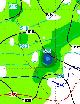
If you review my prior post, the blocking ridge of high pressure will remain in place for at least the next 2 weeks, and probably longer. That blocking ridge creates a corridor, and favorable northwest flow, for storms to drop down the coast and have a significant affect on our weather. Expect a good 4 or 5 decent storms to drop down the coast and bring moderate to heavy snow to the Sierra over the next few weeks. That of course includes Tahoe. Here is the timing for now:
Early Friday Morning (2/25)

Late Saturday Night (2/26)

Thursday Morning (3/3)

March 8th

The further out these storms are, the more they are subject to change. I think, however, you get the picture. We will have a few nice sunny days in between decent sized storms for the area. For each storm, as we get closer, I will refine amounts and timing.
You might as well store the golf clubs, winter is back!
Stay Tuned ...
If you review my prior post, the blocking ridge of high pressure will remain in place for at least the next 2 weeks, and probably longer. That blocking ridge creates a corridor, and favorable northwest flow, for storms to drop down the coast and have a significant affect on our weather. Expect a good 4 or 5 decent storms to drop down the coast and bring moderate to heavy snow to the Sierra over the next few weeks. That of course includes Tahoe. Here is the timing for now:
Early Friday Morning (2/25)
Late Saturday Night (2/26)

Thursday Morning (3/3)

March 8th

The further out these storms are, the more they are subject to change. I think, however, you get the picture. We will have a few nice sunny days in between decent sized storms for the area. For each storm, as we get closer, I will refine amounts and timing.
You might as well store the golf clubs, winter is back!
Stay Tuned ...