Round Three Will Be Much Colder
The timing for our next storm will remain Friday afternoon and evening. This storm will have much colder air to work with, but not nearly as much moisture. Having said that, I look for the Sierra Crest to pick up 1-2 feet of snow. The snow to water ratio will be much higher, in the 15-1 or even 20-1 ratio. For you Slide Mtn enthusiasts, I am looking for 6-18 inches by Saturday morning. This event may only last for a few hours and a blocking wind is in place. There will be some spillover to the valley and it will be all snow. Perhaps an inch or two (in the valley).
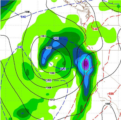
Here is the GFS forecast for late Friday afternoon.
 I should mention that EC has this storm coming in about 8 hours later than GFS, but the conventional wisdom is that GFS is right on this one. Either way, Saturday morning should be epic with plenty of champagne powder.
I want to talk about two other storms. The first is slated for late Sunday into Monday. These storms are born in the south and will have a more direct hit on us. They will also bring more precip to the central and southern Sierra. Here is the GFS look for Sunday, later afternoon:
 Because of the trajectory of this storm, it will have a more profound affect south of us. However if this storm shifts just a little to the north, we could be talking about major dumpage. For now I am looking at 6-18 inches for the Crest west of Tahoe and nearly that for the Carson Range.
I have been yacking away about a much bigger storm slated for Thursday the 24th of March. GFS has stuck to its guns on this and even the NWS was starting to mention this in their blog. I will show you the GFS forecast for next Thursday. Please remember that a week is a long time, especially this time of year when things can change in a hurry. If this holds together, this will be the biggest of the bunch:
Because this blog claims long range weather forecasts for winter enthusiasts, I am going to talk about one more storm. This one is slated for the 27th of March and should come right on the heels of the above storm. Here is the GFS forecast:

When we get in a stormy pattern, models have a tendency to over predict and stay with the status quo. The NOAA PNA is trending positive starting toward the end of next week, which means my hope is higher then my confidence for these long range forecasts. I will keep a close eye and report accordingly. For now, get up the mountain, we have the best conditions in the world right now!
Stay Tuned ...
Here is the GFS forecast for late Friday afternoon.

I want to talk about two other storms. The first is slated for late Sunday into Monday. These storms are born in the south and will have a more direct hit on us. They will also bring more precip to the central and southern Sierra. Here is the GFS look for Sunday, later afternoon:

I have been yacking away about a much bigger storm slated for Thursday the 24th of March. GFS has stuck to its guns on this and even the NWS was starting to mention this in their blog. I will show you the GFS forecast for next Thursday. Please remember that a week is a long time, especially this time of year when things can change in a hurry. If this holds together, this will be the biggest of the bunch:

Because this blog claims long range weather forecasts for winter enthusiasts, I am going to talk about one more storm. This one is slated for the 27th of March and should come right on the heels of the above storm. Here is the GFS forecast:

Stay Tuned ...