Posts

One Shot to Put Out Kings Fire

Image
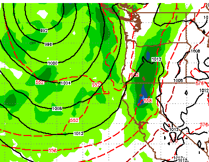
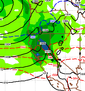
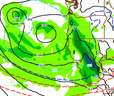
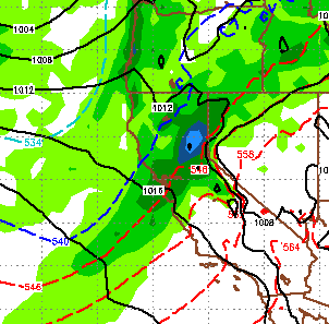
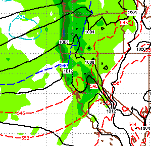
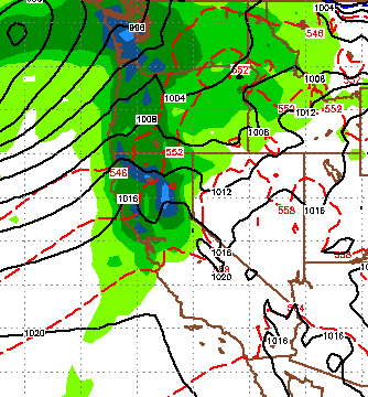
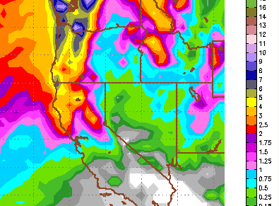
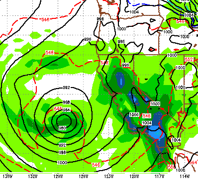
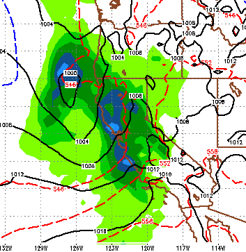
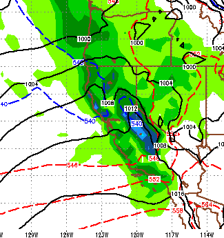
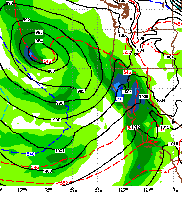
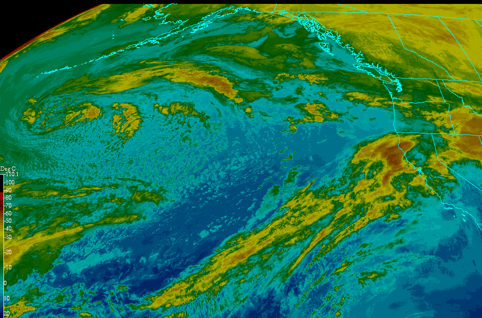
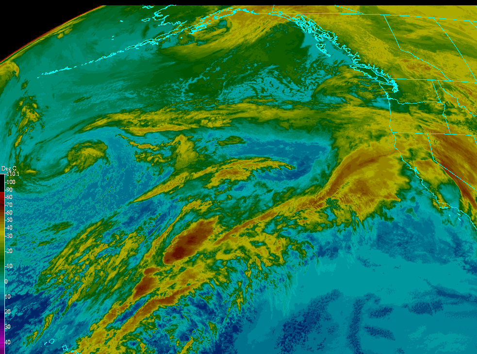
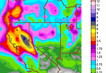
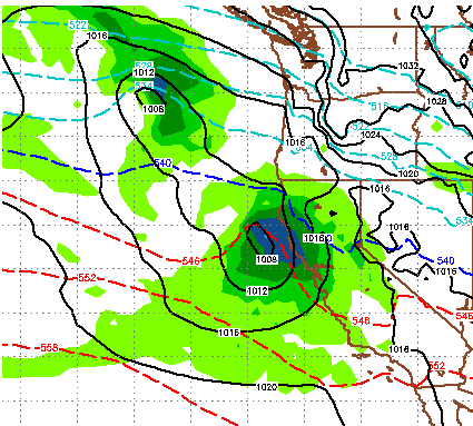
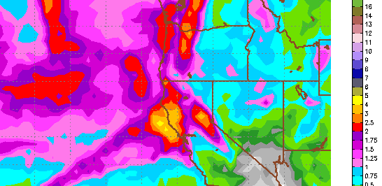
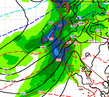
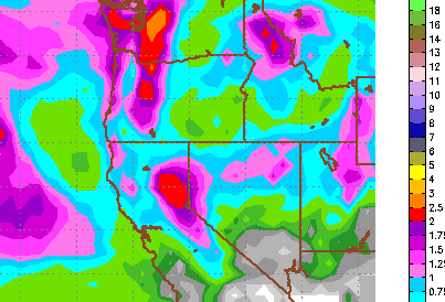
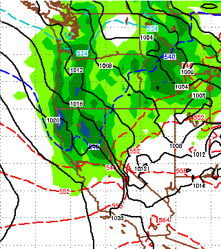
The seasons first Northern Pacific storm comes rolling in this week. Looking at the weather for the next 2-3 weeks, this is our only shot to give the 5,000 fire fighters a chance to dampen, or if we get really lucky, put that thing out. Here is a look at the forecast for late Thursday: This storm is coming surprisingly south for this time of year. It will bring quite a bit of moisture with it, at least for this time of year. That will turn up the humidity and turn down the temps. It is suppose to weaken the further inland it moves, however if we get really lucky, the entire Kings Fire could get a good soaking. Temps will drop around 15-20 degrees and then slowly recover by Sunday. There is a chance for much cooler air to come into the area the following weekend, but let's not get ahead of ourselves. El Nino - 2014 New satellite images are restoring hope for at least a weak to moderate El Nino event that could occur in November/December. Remember last May the forecasters

Winter 2014/2015; Anything but Certain

Back in May I received a preliminary ENSO report from a commodity trader. That report called for an epic El Nino starting in July. By epic I mean stronger than strong. Because of our recent dry conditions, I decided to hold off on telling you all to get ready for the 2014/2015 ski season that is sure to be the greatest. I am glad I held off. Briefly: El Nino is a weather anomaly where waters off the west coast of Central America (Equatorial Pacific) warm. When that happens a number changes are supposed to take place in the atmosphere, starting with a reversal of the trade winds. That reversal of the winds usually brings wetter and warmer storms further south into California. That has yet to materialize. Because of the lack of storms this time of year, you may be saying, what is he talking about? I am not talking about the storms I am talking about the trade winds and the southern jet stream which are still on their traditional course, the westerlies have simply failed to materialize

As Mountain Closes, Storm Door Opens

Image
We have a series of storms heading our way as the storm cycle restarts. With Mt. Rose closed, there are still plenty of other areas to get your fix. We can certainly use the precip. Starting Monday, we will notice a change. By the time Tuesday roles around we are looking at 20 degree cooler high temperatures and stormy weather. The mountains will pick up some snow. An unusually large storm is heading our way for next weekend. It is going to park over our area and effect our weather Friday-Monday. Here is a look at late Saturday night: This storm should be a major precipitation event for the Sierra, especially for this time of year. The storm will take it's time getting here and take it's time leaving. Here is a look at the total precip for the event: The crest of the Sierra will pick up 4-5 inches of liquid precip. Snow levels, however, will be very high. Usually this time of year, storms have trouble making it over the crest. I see 2-3 inches liquid headed for th

Next Storm Should Hit Late Tonight

Image
The 3rd storm in the last week is approaching as I write this and should hit late tonight. This will not be as big as the storm we saw on Saturday and very early Sunday, but will leave more preicip especially west of the crest and south of Lake Tahoe. Here is a look at the forecast for late tonight: This storm is also going to slide down the crest. Like the last storm, the Carson range could get shadowed out. Amazing the difference in precip between the crest of the Sierra and the Carson range. Sugar Bowl reported 5 feet of snow, while Mt. Rose got around a foot. I drove over the Donner Summit yesterday and it was pretty amazing the amount of snow they picked up in 36 hours. By the time we got to Truckee there was just a minor amount. When forecasting the weather, it is really hard to predict the rain shadow anomaly. Suffice it to say, very beneficial rains fell west of the crest in both the northern and central Sierra. I would expect more of the same with this storm to a lesser

Tahoe In Bulls Eye For Next Two Storms; El Nino on the Horizon

Image
Not a lot has changed with our forecast from earlier in the week. The first of the three storms we forecast came through and brought winter back to the region. It also left behind some much needed moisture. As we said, this was the weakest of the storms. The next two storms are going to pack much more moisture. The next storm begins to make its presence felt for the Sierra early Saturday Morning. This storm will develop and pick up moisture from the Pacific. This storm will hang around for about 36-48 hours and should dump 2-4 feet of snow on the Western Crest and about half that in the Carson Range by Sunday night. Here is a look at Saturday night's forecast: Right behind this system is the next system which makes its approach around noon on Monday. Here is a look at the forecast for Monday around noon, I expect similar precip numbers from the Saturday/Sunday storm: Here is a look at total liquid precip for the next 6 or so days: As I look out to next week, an

Stormy Week Starts Late Tuesday

Image
A series of storms are going to break down our ridge of high pressure and bring a major change in our weather pattern starting tomorrow night. Today and Tomorrow will be our last calm days for some time to come. As NOAA has issued an El Nino watch, we can expect a more unstable weather pattern through the spring and possibly into the summer. First let's look at this next week: First, weak storm should have an effect on our weather starting Tuesday Evening. This storm will stick around for about a day or two. Next stronger storm, gathers its strength to the north and comes in late on Saturday. This is a stronger storm but will only stick around for about 12-18 hours. This storm has major precip associated with it so if it slows just a bit, look for a major event. Third and strongest storm (of the week) comes in around 2:00pm on Monday, March 31st. This storm will have an impact on the Central Sierra as well. This storm and the remnants of it, could stick around through Wednesday

Warm, Sloppy Storm Arrives Early Tomorrow Morning

Image
We have been talking about this storm for over a week now. The timing has not changed as this storm will drop into our ares from the north and west. It will tap into the very warm and moist air out int he Pacific and bring some rain to the Sierra below 9,000 feet to start with. As the front moves through those snow levels will drop to around 7,500 feet. This storm is fast moving and should drop around a foot of snow around the upper elevations of the Sierra Crest west of Lake Tahoe. About half that in the Carson Range (as usual). Here is a look at the forecast, notice the approaching storm, this should be late tonight: Snow should last through the morning tomorrow and the afternoon ... however at elevation, which is going to be very high for this storm. Most resorts over on the west side, that are challenged for elevation will receive all rain. We have also been talking about another storm in the series for Sunday and Monday. Here is a look at very late on Sunday night: The

Active Weather Pattern Continues

Image
As our active weather pattern continues, we have a decent shot for snow tonight & tomorrow, Wednesday and Thursday and then the following Sunday and Monday. Our best chance for a good storm and thus a powder day is very late Wednesday into Thursday, with snow most of the day, which means Friday would be the day. Prior to that it is going to warm up ahead of the storm. Snow levels will be around 6,500-7,000 for tonight/tomorrow and around 7,500 feet for the Wednesday/Thursday storm. Here is a look at precip estimates for the week: As usual, north and west of the lake is the big winner looking at 2-4 inches of liquid precip possible with around an inch for the Carson Range. Of course all of this can change ... there is a ton of moisture to tap into. If the dynamics of these storms change even slightly, we could be talking about significantly more precip. Last post we talked a little bit about two weather dynamics that will make for an active Spring; and El Nino has develope

Are Weather Patterns for our Area Really Changing?

Image
I will address what appears to be a long term and possibly violent change in our weather pattern. First here is a storm update. The first wave has pushed through and brought with it some cold air. The most snow fell in the Central Sierra where Mammoth picked up nearly 2 feet. 6-12 inches fell on Rose. The next wave is coming in tomorrow around 4:00pm. It will again have a bigger impact south of here, especially Southern California. Here is a look at 4:00 tomorrow: We are going to get a decent amount of snowfall up here, but much of the moisture will fall south of here, where they really need it! These two storms have been a real blessing for the state. I call it free water for all, but the miracle of desalinating the trillions of trillions of gallons of water and dumping it on California is drought stricken areas is fantastic news and supports the law of averages, they were really due. The storm that I am keeping an eye on has Tahoe in its cross hairs for next Thursday. This

7-10 Days of Storms Begin Thursday

Image
Our pattern has completely changed because of a number of factors. Storms are now moving across the Pacific, raining on Hawaii and coming our way. The Westerlies have finally returned. What does that mean? Rain for all of California. Potentially lots of it! Mammoth Mountain is in for a very stormy 10 day period starting Thursday. So is Tahoe. In fact, when all is said and done, Tahoe looks to be back in the bulls eye. Although some very beneficial precip should fall on all of California. Starting very early on Thursday, the first wave moves in: Then Friday evening the next wave moves in, notice the storm just off the coast: Another wave should affect Northern California, including Tahoe next Monday as the stormy pattern continue until late next week. Finally, as we expected the total liquid precip numbers have gone up for the event: The western crest around Tahoe is looking at 7-8 inches of liquid precip. A big part of California is in the 4-5 inch range. The Car

March Coming in Like a Lion

Image
We will have a general warming trend through about the middle of next week. Look for dry weather with highs around 60. Then things change. We have been talking about the possibility of a pattern change coming at the end of February for the last week now. As we approach that date, the models are in surprising agreement that we could be in for a major and very beneficial pattern change. We also talked about our friends in the Central and Southern Sierra joining in on the fun. It has been dry down there for over a year. Well it looks like our wish may come true. There are a series of storms making a beeline right for Central California, right in the heart of farm country, where they need it most. Remember, this is still a week out, but when the models are seeing this and a number of other factors are suggesting (Late Phase strengthening MJO) this, my confidence is reasonably high. Here is a look at the first wave, set for the February 27th: Heavy moisture this time with the

Storm For Wednesday Fizzles Out, High Pressure Take Control for Next Week

Image
The storm I was trying to will into our area appears to have fizzled out and will not make it down with any favorable precipitation. That is unfortunate, as the high pressure ridge to our west will move north for at least a week and block anything from coming into our area. It will get windy on Tuesday and a cold front will pass through the area. However, that will only drop temperatures to average for this time of year. However, those temps will quickly move to above average and stay that way for the next 7-10 days. In my last post I hinted that more significant change may be coming for March. It is very difficult to forecast weather more than a few days out. However, checking a number of weather models, a chance exists for a significant change to our current weather pattern. Right now, that change looks to be starting in about 10 days. The EC model, which is the most reliable, has a significant storm affecting the entire state of California. Hopefully this holds true, as the centra

Two Storms, Then High Pressure Takes Control

Image
The wind that we have experienced the last few days is a storm to the north that will eventually push some moisture down toward Tahoe. At this point it is not looking like much. We have two storms coming and both are at the very southern tip of precip. First here is a look at late Saturday night: We are on the warm side of this storm and snow levels again will be very high. Most of the precip will be confined to west of Lake Tahoe. The Carson range may pick up a few inches (6 inches if we are lucky) and as much as a foot for the Western Crest of the Sierra. Late on Tuesday a second storm comes in. That storm will be similar to this storm, but could provide more precip further east. With it will come a cold front that will push temps about 15-20 degrees cooler. Our 60's and 70's will be 40's and 50's after Wednesday. Here is a look at late at Tuesday night: These storms are pretty disappointing. I was hoping to build on the momentum of last weekends super st

Storm Continues to Slam Tahoe - Avalanche Warning, Extreme Back Country Conditions

Image
First the important stuff; BEFORE YOU GO OUT IN THE BACK COUNTRY, CLICK THE FOLLOWING LINK AND EDUCATE YOURSELF, STAY ALIVE: Extreme Avalanche Warning Lake Tahoe is right in the bulls eye of one of the biggest storms we have seen in years. As sub tropical moisture is pulled from the southwest moisture plume and our low pressure system has stalled (actually moved west), copious amounts of rain and snow have fallen around the entire Tahoe area. Some of the snow totals are staggering! Squaw Valley has picked up over 5 feet, while Mt. Rose is closing in on 3 feet. There is still another 18 hours (at least) to go on this storm which could bring some of the heaviest precip we have seen. Here is a look at the current conditions, you can see our Pineapple Express is still very much intact and feeding our low pressure system: By the time this is over, many west Tahoe ski areas, like Sugar Bowl and Squaw Valley, could be in the 7 foot range of total snowfall. Mt. Rose will probably go

Pineapple Express

Image
Here is a beautiful shot from space of the anomaly we affectionately call the Pineapple Express. Remember you can click on the picture to enlarge: Checking this morning's run of the weather models, I see no change to my forecast and timing from yesterday. The difficult to predict variable for this giant storm and the subsequent waves of moisture it will send our way is snow levels. The NWS is saying they believe snow levels will NOT rise above 8,000 feet and should stay around 7,000 feet for most of the weekend. I believe they will be higher. Those guys do this for a living, I do not. So hopefully they are right. See yesterday's post for a complete storm synopsis. Next Weekend The next chance for a significant storm comes in next weekend, probably Sunday. Hopefully this holds together like this weekend's storm. Here is the EC look for President's day weekend: Our ridge of high pressure is starting to get moved around. Ironically, the real pro's basica

66 Hours of Precip Coming to Tahoe Sierra

Image
I just checked the latest model run and here is what I am seeing: Tahoe is in the bulls eye of a very large storm that will tap into a moisture plume known as the Pineapple Express. Starting at 4:00pm tomorrow (Friday) it will start snowing in the Sierra west of Lake Tahoe. Snow levels will start at about 5,000 feet. That moisture will spill over to the Carson range around 8:00pm. Precipitation will continue as snow levels rise. This is going to be a rapid rise. By Saturday around noon, snow levels will be between 7,000 and 8,000 feet. Those levels could reach 10,000 feet as warm moist air is sucked out of the Pacific moisture plume stretching from Hawaii to Northern California. At about 4:00pm on Saturday, a deep rich wave of moisture will enter the Sierra and Carson Range. This is where snow levels could reach as high as 10,000 feet and this storm could bring heavy rain to both the Sierra and Carson Range. Heavy moisture will continue until about 4:00am Monday morning for the

Storms Poised to hit Tahoe Hard

Image
Two storms are coming our way. In the next week (and maybe longer) Tahoe will see some very welcome precipitation. Storm 1 This storm is coming in tonight and tomorrow. It is the smaller of the storms and the cooler of the storms. Here is a look at the forecast for midday tomorrow: You can see we are right on the edge of the cool/warm air. What develops out of this storm is a giant moisture plume that will stretch from Tahoe to Hawaii. Some refer to this as the Pineapple express. Elevations could start as low as the valley floor but will rise through the entire event. We are looking at around 1-2 feet for the snow prone areas west of Lake Tahoe and about half that for the Carson Range. This should be all snow. Storm 2 As our next storm and much more powerful, wet storm approaches, we are looking at what I will call a major weather event for all of Tahoe. We seem to be right in the bulls eye. As this storm taps into a giant moisture plume, it will stall ... and dump. Howev

Dry Cool Weather Until Next Weekend, Then Good Chance for Winter Storm

Image
The cold front is firmly in place and we are going to get a few reinforcing shots of more cold air on Sunday and then again next Friday. We will get some light snow showers Sunday and Monday, however at this time it looks like accumulations will be minimal. Next Thursday is our next chance for some measurable snow in the Sierra as a shortwave will drop down out of the Pacific Northwest. Models in good agreement that will bring us some precip around Thursday with a cold front behind. Then as the PNA goes negative again, a stronger system will drop out of the Gulf of Alaska and should make it in to Tahoe with plenty of moisture. Of course we are still pretty far out, but models are in surprisingly good agreement and it appears that a number of factors will fall into place. This is the forecast for total precipitation next weekend: The possibility exists for some areas to pickup as much as 4 inches of liquid. With the colder air in place, snow levels for this system will be muc

Storm Update and What's Ahead

Image
This very quick moving, storm has brought very beneficial moisture to all of Tahoe and the western Nevada valleys. It is not quite over. I expect another 2-4 inches up at Rose by Tomorrow. Some models are saying more. The snow levels started very high, near 10,000 feet, and took some time to move down. Therefore the resort snow totals are relatively low with Rose being the winner and accumulating 8-12 inches. That number should increase to near 16 inches by Friday with an outside chance of slightly more. However the moisture impact should be significant because of the rain for nearly all resorts. We have been in a very dry spell and 2-3 inches of liquid precip has fallen in the Sierra all around Tahoe. The California coast will pick up more moisture come Sunday as a system moves straight down the coast. There is some chance that we could pick up some of that. I am focusing on a large storm for the following weekend, but that is still way out. Hopefully that holds together. Here i

As Storm Moves In, Will This Change Our Long Term Weather Pattern?

Image
A decent sized storm is poised to hit the Tahoe area and should leave behind 18-30 inches of snow for all areas around Tahoe above 8,000 feet. This storm, which is packing abundant moisture, will come in warm on late Wednesday. Snow levels will start out at about 8,000 feet. As the front moves through the snow levels will plunge to the valley floor by Friday morning. The Sierra Crest is forecast to pick up about 2.5 inches of liquid precip. Slightly lesser amounts can be expected for the Carson range. However, if you are a Mt. Rose skier, the elevation of Rose is such that it will be the big benefactor of this storm with all snow. I would not be surprised to see a couple of feet by Friday afternoon. The following is the EC total precip map for the event: We are very pleased to finally get some moisture in the forecast. Does this suggest a change in the long term outlook? Remember, many forecasters had written off 2014 altogether (See Ken Clark at Accuweather.com). Or, does thi

Dry Weather Continues; Historic 13 Months

Image
As the rest of the country continues to get blasted by a very harsh winter, one of the coldest on record, we have been very well protected by a ridge of high pressure which has moved up the coast and is keeping us in warm weather and sunshine. Hard to complain about the weather. This should continue for at least the next 10 days. I will talk about day 10 shortly. First I want to show some charts on just how dry our weather has been. This first map represents what is our traditional rainy season. Of course we know we were nearly shut out of any rain whatsoever. Notice almost all of Northern California has picked up less than 5% of the average rainfall for the rain season. Pretty Amazing and potentially catastrophic. The major reservoirs in California are in big trouble. When they should be filling up, they are getting no water. In addition they are all very low because of the record dryness of 2013 (See  Previous Post). I have been searching for the better part of two weeks

Suggestions For Changing The Weather Pattern

We like to have fun here at the TWB. If you are looking for hard core scientific data, perhaps you should read no further. I just wanted to let all my faithful readers know that I am doing what I can. In the last 2 days I have done the following: Washed Car, Inside and Out Cleaned Gravel and Salt of Garage Swept Driveway Removed Ski Rack from Car Number 4 could be the clincher! The above list usually brings in some inclement weather. I believe if we all put our collective positive energy together, we can change the pattern ourselves! I did look at both GFS and EC models and they are in agreement for a quick moving weather event on Sunday that could bring up to a foot of snow to the Sierra.

When it Changes it will Really Change. For Now, Looks Like the Status Quo

Image
I just looked at the latest EC run. Unfortunately, the smaller storms for this week appear to have fallen apart. Our blocking ridge is moving south, but also east. That means it will continue to block any storms from coming into our area ... yucksville! There is a glimmer of hope for late Saturday into Sunday for some reasonable precip as the biggest of the systems will shove that ridge south and west, perhaps allowing for a short storm window. EC is still forecasting the following for Sunday morning: Unfortunately, immediately after this storm our blocking ridge appears to be moving well north and east. Remember this; There are no normal weather events. Forecasters rarely use the word normal, when they do it is a mistake. Especially for our area. There are only averages. 3 years ago we were inundated with record breaking snow. Parts of Squaw Valley had a season total of nearly 1,000 inches of the white stuff. The law of averages has caught up with us these past two years. Ho

Enjoy This Weather, It Will Change Early Next Week

Image
A series of small systems could come through our area starting next Tuesday. The stormy weather could last through the following weekend with each system getting progressively larger culminating on the 11th with a major precip event. Again I say "could" because, as you know, weather forecasting has been challenging to say the least these past few months. Here is a look at the forecast larger storm for the weekend of the 11th: My confidence of a major change is due to mounting evidence from a number of fronts. We first talked about the PNA and AO both going negative simultaneously. That should allow some of that Arctic air to slip into our weather pattern instead of the eastern 2/3 of the USA. The biggest change is the shifting of the blocking ridge of high pressure to a more traditional position. This should allow a storm corridor to form: Here is a forecast look for this weekend: As you can see, the blocking ridge of high pressure is in a terrible position. It